
Magway Region is an administrative division in central Myanmar. It is the second largest of Myanmar's seven divisions, with an area of 44,820 km2. Pa Del Dam (ပဒဲဆည်) is one of the dams in Aunglan Township, Magway Division. The capital and second largest city of the Magway Division is Magway. The largest city is Pakokku. The major cities of Magway Division are Magway, Pakokku, Chauk, Aunglan, Yenangyaung, Taungdwingyi, Minbu, Thayet and Gangaw.

The Chindwin River is a river flowing entirely in Myanmar, and the largest tributary of the country's main river, the Ayeyarwady.Its official name is also spelled Chindwinn.

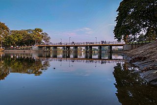
Aunglan is the biggest city in Thayet District of the Magway Region of Myanmar. It is a port on the left (eastern) bank of the Irrawaddy, across and just north of Thayetmyo, between the cities of Pyay (Prome), Taungdwingyi (Prome) and Magway. It is the administrative seat for Aunglan Township. According to the 2014 census, the population was estimated as over 235,000. The rural population is over 182,000 and urban population is 52,865. 47.5% of total population is male and 52.5% is female. Aunglan was a new city formed moving from Myede. After the second Anglo-Burmese war, the south of Myede Township was annexed by the British and the north was ruled by the Myanmar King.
Kyaukpadaung Township is a township of Nyaung-U District in Mandalay Region of Burma (Myanmar). Its administrative seat is the town of Kyaukpadaung. Important towns include Popaywa and Seiktein (Seikhtain).
Taungdwingyi is a town located in Magway Region, Myanmar.
Magway Township is a township of Magway District in the Magway Region of Myanmar. The principal town is Magway.
Yenangyaung Township is a township of Magway District in the Magway Division of Myanmar. Yenangyaung is bordered on the south by Magway, on the east by Natmauk, on the north by Chauk, on the northeast by Kyaukpadaung and on the west by the Ayeyarwady River. The principal town is Yenangyaung.
Taungdwingyi Township(Burmese: တောင်တွင်းကြီး မြို့နယ်) is a township of Magway District in the Magway Division of Myanmar. The principal town is Taungdwingyi. People have inhabited this area for thousands of years, and one of the earliest civilizations of Myanmar, Beikthano, the ancient Pyu city, is located near the town. The territorial area is planes, and rice, beans, grains, sugarcane, and other plants were grown there.
Myothit Township is a township of Magway District in the Magway Division of Myanmar. The principal town is Myothit.
Natmauk Township is a township of Magway District in the Magway Division of Myanmar. The principal town is Natmauk. It is the place where General Aung San who is national hero of Myanmar and father of Aung San Su Kyi, was born.
Minbu District is a district of the Magway Division in central Myanmar. The city of Minbu is the administrative centre.Minbu District has 5 townships.
The Daaquam River is a river primarily flowing in the administrative region of Chaudière-Appalaches, at South of Quebec in Canada and northern Maine, in United States. The river runs from its source, south of Sainte-Justine, northeast across the Canada–United States border to the Northwest Branch of the Saint John River in Maine.
The Southwest Branch Saint John River is a 62.0-mile-long (99.8 km) river in Maine and Quebec. The branch originates in "Little Saint John Lake" on the international boundary between Saint-Zacharie, Quebec and Seboomook Lake Township 5, Range 20, WELS. The branch forms the Canada–United States border as it flows northeasterly to a confluence with the Little Southwest Branch Saint John River in Seboomook Lake Township 9, Range 18, WELS. The Southwest Branch flows briefly into Quebec and then through Maine to its confluence with the Baker Branch Saint John River in Seboomook Lake Township 9, Range 17, WELS. The Southwest Branch finally joins with the Northwest Branch to form the Saint John River.

The University of Community Health, Magway (UCH) is a Community Health University under the Ministry of Health and Sports (Myanmar), and located in Magway city, Myanmar. The university offers a four-year Bachelor of Community Health (B.Comm.H) degree program. Students have to study how to perform Community health. Also, they must take clinical subjects as integration for rural population whom can't get primary health care. Formally, the graduates are allowed to practice as Health Assistants (HA) in Department of Public Health and FDA of Myanmar, many of whom are the main providers of primary health care in rural Myanmar where access to regular physicians is difficult.

Sidoktaya, also Sitoktaya or Setoketaya is a town and seat of Sidoktaya Township in Minbu District of Magway Division, situated in middle west region of Burma. It is bordered with Salin township to the east, with Pwintbyu township to the south-east, with Ngape township to the south, with Minbya township to the west, with Kanpelek township to the north-west and with Saw township to the north. It is a hilly region of Rakhine. Mount Sun Taung, the highest mountain in Rakhine, 6,527 feet (1,989 m) high, is in Sidoktaya township.
The Yin River is a river in Magway Region, in central Burma (Myanmar), a tributary of the Irrawaddy.
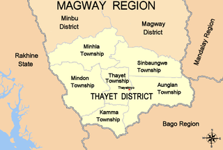
Thayet District is a district of the Magway Division in central Burma (Myanmar). The administrative centre is the town of Thayet.
Sinbaungwe Township or Tantabin Township is a township of Thayet District in the Magway Region of Burma (Myanmar). It is located to the west of the Pegu Range in the foothills and on the plain of the Irrawaddy. Most of the township is east of the Irrawaddy, but about 20% of the township lies on the right (west) bank. The major town and administrative center is Sinbaungwe (Tantabin).
Minhla is a town in Thayet District, Magway Region, of central Myanmar, on the right (west) bank of the Irrawaddy. It is the administrative seat of Minhla Township.

Beikthano situated in the irrigated Magway Region, near present-day Taungdwingyi. In the era of the Pyu city-states it was a city of considerable significance, possibly a local capital replacing Sri Ksetra. Today the modest village is noted for its hot springs and archaeological sites. Beikthano, Hanlin, and Sri Ksetra, the ancient cities of the Pyu Kingdom were built on the irrigated fields of the dry zone of the Ayeyawady River basin. They were inscribed by UNESCO on its List of World Heritage Sites in Southeast Asia in May 2014 for their archaeological heritage traced back more than 1,000 years to between 200 BC and 900 AD.

