Related Research Articles

Lancashire is a ceremonial county in North West England. It is bordered by Cumbria to the north, North Yorkshire and West Yorkshire to the east, Greater Manchester and Merseyside to the south, and the Irish Sea to the west.

Blackpool is a seaside resort town in Lancashire, England. It is located on the Irish Sea coast of the Fylde peninsula, approximately 27 miles (43 km) north of Liverpool and 14 miles (23 km) west of Preston. It is the main settlement in the borough of the same name. The population of Blackpool at the 2021 census was 141,000, a decrease of 1,100 in ten years.
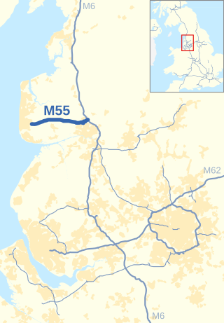
The M55 is a motorway in Lancashire, England, which can also be referred to as the Preston Northern Bypass. It connects the seaside resort of Blackpool to the M6 at Preston. It is 12.2 miles (19.6 km) in length.

The Blackpool Tramway runs from Blackpool to Fleetwood on The Fylde in Lancashire, England. The line dates back to 1885 and is one of the oldest electric tramways in the world. It is operated by Blackpool Transport Services (BTS) and runs for 18 km. It carried 4.9 million passengers in 2022/23.

Blackpool South is a constituency in Lancashire, England, which has been represented by Chris Webb of the Labour Party since a 2024 by-election.

Kirkham and Wesham railway station serves the Lancashire towns of Kirkham and Wesham, in England. It is managed by Northern Trains, who operate most of the passenger services that call there.
A.F.C. Blackpool is a football club based in Blackpool, Lancashire, England. The club currently play in the North West Counties League Division One North. Based at Jepson Way, they are nicknamed The Mechanics or The Mechs, and are full members of the Lancashire County Football Association.

Blackpool North was a borough constituency in Lancashire which returned one Member of Parliament to the House of Commons of the Parliament of the United Kingdom.
The A583 is a primary road from Preston to Blackpool in England, via Kirkham. It runs a distance of 17 miles (27.4 km), and was previously the main route into Blackpool until the construction of the M55 motorway.
The Fylde is a coastal plain in western Lancashire, England. It is roughly a 13-mile-long (21-kilometre) square-shaped peninsula, bounded by Morecambe Bay to the north, the Ribble estuary to the south, the Irish Sea to the west, and the foot of the Bowland hills to the east which approximates to a section of the M6 motorway and West Coast Main Line.

The A588 is a road in western Lancashire, England, which runs for around 20 miles (32 km), from Poulton-le-Fylde northeastwards to Lancaster. It is the main route serving the Over Wyre areas of the Fylde.

The A587 is a road in England that runs from Blackpool to Fleetwood in Lancashire.

Marton Mere is a mere (lake) and Local Nature Reserve in Blackpool, Lancashire, England. It is located near to the Blackpool districts of Marton and Mereside and the village of Staining. It is recognised as a Site of Special Scientific Interest. It supports various habitats such as open water, reed beds, grassland as well as pockets of woodland and scrub.

The City of Preston, or simply Preston, is a local government district with city status in Lancashire, England. It lies on the north bank of the River Ribble and has a population of 151,582 (2022). The neighbouring districts are Ribble Valley, South Ribble, Fylde and Wyre.

Longworth was a township of the civil and ecclesiastical parish of Bolton le Moors in the Salford hundred of Lancashire, England. In 1891 it had a population of 102.

Marton is a historic village on the coastal plain of the Fylde in the Borough of Blackpool in Lancashire, England, most of which is now forms a part of the town of Blackpool. Marton, consists of Great Marton, Little Marton, Marton Fold and The Peel.

Little Marton Mill is a 19th-century English tower windmill in Marton, Blackpool, Lancashire, England. It was built in 1838 by John Hays for grinding corn, and worked until 1928. It has been designated a Grade II listed building by Historic England.

The Borough of Blackpool is a unitary authority area with borough status in the ceremonial county of Lancashire, North West England. It is named after the seaside town of Blackpool but covers a wider area which includes Anchorsholme, Bispham, Layton, Marton and Squires Gate. As well as the suburbs of Grange Park, North Shore, South Shore and Starr Gate. The borough also forms the core of the wider Blackpool conurbation.

Hillylaid Pool is a water channel running through the Fylde and Wyre areas of Lancashire in England. It is 4.55 miles (7.32 km) long, and it is part of the Fleetwood Peninsula Tributary catchment area.
References
- ↑ 53°48′33″N2°59′56″W / 53.8093°N 2.9990°W
- ↑ "Blackpool History". 29 September 2007. Archived from the original on 29 September 2007. Retrieved 9 July 2024.
- ↑ 53°51′43″N2°58′36″W / 53.8620°N 2.9767°W
- ↑ "Lancashire County Council". 24 July 2023. Archived from the original on 24 July 2023. Retrieved 9 July 2024.
Geography of the Borough of Fylde | ||
|---|---|---|
| Towns |  | |
| Villages | ||
| Parishes | ||
| Topography |
| |
| | This Lancashire location article is a stub. You can help Wikipedia by expanding it. |