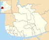
The Borough of Fylde is a local government district with borough status in Lancashire, England. It covers part of the Fylde plain, after which it is named. The council's headquarters are in St Annes. The borough also contains the towns of Kirkham, Lytham and Wesham and surrounding villages and rural areas.

Wyre is a local government district with borough status on the coast of Lancashire, England. The council is based in Poulton-le-Fylde and the borough also contains the towns of Cleveleys, Fleetwood, Garstang, Preesall and Thornton, along with numerous villages and surrounding rural areas. Some of the borough's built-up areas form part of the wider Blackpool urban area. Eastern parts of the borough lie within the Forest of Bowland, a designated Area of Outstanding Natural Beauty.

Poulton-le-Fylde, commonly shortened to Poulton, is a market town in Lancashire, England, situated on the coastal plain called the Fylde. In the 2021 United Kingdom census, it had a population of 18,115.
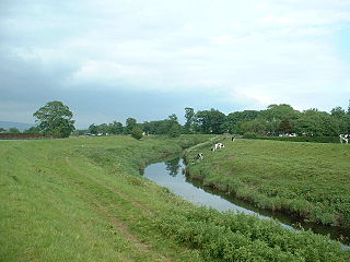
The River Wyre, in Lancashire, England, flows into the Irish Sea at Fleetwood. It is 28 miles (45 km) long and has a sheltered estuary which penetrates deep into the Fylde peninsula.

Bryning-with-Warton is a civil parish in the Borough of Fylde in Lancashire, England.
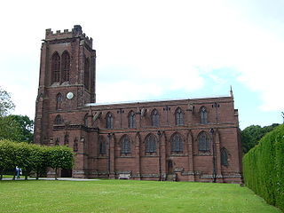
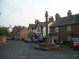
Eccleston is a village and former civil parish, now in the parish of Eaton and Eccleston, in the borough of Cheshire West and Chester, in the ceremonial county of Cheshire, England. The village is approximately 2.7 miles (4.3 km) to the south of the city of Chester, near to the River Dee. The village is situated on the estate of the Duke of Westminster who maintains his ancestral home at nearby Eaton Hall.
Kirkland is a civil parish, located on the banks of the River Wyre, midway between Preston and Lancaster, in the English county of Lancashire. It is also the historic name of what is now the village of Churchtown, within the parish. It is part of the Wyre district. In 2001 the parish had a population of 343, decreasing to 314 at the 2011 census.

Hambleton is a village and civil parish in the English county of Lancashire. It is situated on a coastal plain called the Fylde and in an area east of the River Wyre known locally as Over Wyre. Hambleton lies approximately 3 miles (4.8 km) north-east of its post town, Poulton-le-Fylde, and about 7 miles (11 km) north-east of the seaside resort of Blackpool. In the 2001 United Kingdom census, the parish had a population of 2,678, increasing to 2,744 at the 2011 census.
Out Rawcliffe is a village and civil parish on the north bank of the River Wyre in the Over Wyre area of the Fylde in Lancashire, England. The population of the civil parish taken at the 2011 census was 626.

Elswick is a rural village and civil parish on the Fylde coast of Lancashire, England. At the 2011 Census, it had a population of 1,079.

The A585 is a primary road in England which runs from Kirkham to Fleetwood in Lancashire.

Great Eccleston is a village and civil parish in Lancashire, England, situated on a coastal plain called the Fylde. The village lies to the south of the River Wyre and the A586 road, approximately 10 miles (16 km) upstream from Fleetwood. At the 2001 census, the parish had a population of 1,473, rising slightly to 1,486 at the 2011 census.

Mawdesley is a village and civil parish in Lancashire, England, which had a population of 1,702 as per the 2011 Census.

The A586 is a road in Lancashire, England, which runs from Garstang to Blackpool.

Inskip-with-Sowerby is a civil parish in the Borough of Wyre, in Lancashire, England. A part of the Fylde, the parish includes the village of Inskip and the hamlets Crossmoor to the west and Sowerby to the east. Also Inskip Moss Side lies about a mile north-west of the village at grid reference SD452391. In 2011 it had a population of 840.

Cartford Bridge is a single-track toll bridge in the English county of Lancashire. Built in 1831, it spans the River Wyre, connecting Little Eccleston-with-Larbreck, in the Borough of Fylde, on the southern side of the river, to Out Rawcliffe, in the Borough of Wyre, on its northern side, carrying both automotive and pedestrian traffic of Cartford Lane. The tolls are £1 for vehicles exceeding five tonnes, 70p for vehicles exceeding two tonnes, 60p for motorised vehicles not exceeding two tonnes, and 20p for two-wheeled vehicles. In 1966, it was one of twelve toll bridges on roads in England of level Class III or higher. It is 450 feet (137 m) in length.

Upper Rawcliffe-with-Tarnacre is a civil parish on the Fylde, in the Borough of Wyre, in Lancashire, England. It had a population of 604 in 2001, increasing to 629 at the 2011 Census. The only settlements in the parish are the village of St Michael's on Wyre and the tiny hamlet of Ratten Row. The River Wyre passes through the parish, and the River Brock joins the Wyre on the parish boundary.
Little Eccleston-with-Larbreck is a civil parish in the Borough of Fylde, Lancashire, England. It contains five buildings that are recorded in the National Heritage List for England as designated listed buildings, all of which are listed at Grade II. This grade is the lowest of the three gradings given to listed buildings and is applied to "buildings of national importance and special interest". The parish contains the small settlements of Little Eccleston and Larbreck, and is otherwise rural. The listed buildings consist of farmyards and farm buildings.

The Cartford Inn is a public house and boutique hotel in Little Eccleston-with-Larbreck, Lancashire, England. It stands on the southern banks of the River Wyre, just off the Cartford Bridge, one of the few remaining toll bridges in the United Kingdom, with views to the northeast of the Forest of Bowland.