Elswick, Lancashire

Last updated

Elswick
Elswick Memorial Church - geograph.org.uk - 1528395.jpg
United Reformed Church
Location map United Kingdom Borough of Fylde.svg
Red pog.svg
Elswick
Shown within Fylde Borough
Location map United Kingdom The Fylde.svg
Red pog.svg
Elswick
Shown within the Fylde
Lancashire UK location map.svg
Red pog.svg
Elswick
Location within Lancashire
Population1,079 (2011 Census)
OS grid reference SD421384
Civil parish
  • Elswick
District
Shire county
Region
Country England
Sovereign state United Kingdom
Post town PRESTON
Postcode district PR4
Dialling code 01995
Police Lancashire
Fire Lancashire
Ambulance North West
UK Parliament
List of places
UK
England
Lancashire
53°50′20″N2°52′48″W / 53.839°N 2.880°W / 53.839; -2.880

Elswick is a rural village and civil parish on the Fylde coast of Lancashire, England. At the 2011 Census, it had a population of 1,079. [1]

Contents

At the Norman conquest of England in 1066, Elswick was a small agricultural community in the hundred of Amounderness. The village was originally part of the ecclesiastical parish of St Michael's on Wyre. A Nonconformist chapel was built in Elswick before 1650.

Elswick is part of the local government district of Fylde and the parliamentary constituency of Fylde. It lies approximately 8.5 miles (14 km) east of Blackpool and 12 miles (19 km) north-west of Preston.

History

Elswick was listed in the Domesday Book of 1086 as Edeleswic. In later documents it was recorded variously as Etleswhic, Etheliswyck and Elleswyk. [2] At the time of the Norman conquest of England in 1066, the township of Elswick—as part of the ancient hundred of Amounderness—was in the possession of Earl Tostig, the brother of King Harold II. [3] Tostig died at the Battle of Stamford Bridge and his lands were subsequently taken over by the Normans. Between 1069 and 1086 William the Conqueror gave Amounderness to Anglo-Norman baron Roger the Poitevin. [4] In the Domesday Book, the area of Elswick was estimated at three carucates of land. [2]

In the 13th century, part of the township of Elswick was owned by the lord of Freckleton, and smaller parts by Warine de Whittingham and Alan de Singleton. [2] In the early 16th century, Henry VII's administrator Edmund Dudley held the township and it was later in the possession of Thomas Stanley, 2nd Earl of Derby. [5]

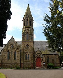
Elswick was part of the Ecclesiastical parish of St Michael's on Wyre and Elswick's villagers would have worshipped at St Michael's Church, approximately 5 miles (8 km) away. [5] [6] By 1650 a chapel had been built in the village which at that point was recorded as containing 50 families. [5] It was intended to be a chapel of ease to St Michael's but was neither endowed nor consecrated, possibly because of the turmoil of the English Civil War. [7] The chapel was licensed in 1671 for use as a Nonconformists' meeting place and used initially by Presbyterian worshippers. [8] When this licence was made illegal, the chapel closed and later reopened as a Congregational chapel. In 1753, it was replaced by a new building, which was enlarged in 1838. This in turn was replaced by a chapel built 1873–74 by H. J. Powell, on land given by a Miss Harrison. [9] [10]

In 1902, a sanatorium for smallpox sufferers was built in the village. It was later a treatment centre for tuberculosis patients and then a probation hostel. [11] It is now a private residence.

Between 1951 and 1956 just off the Roseacre Road between Elswick and Roseacre was the site of a VHF fixer station, part of the RAF Western Sector, and was one of a number similar fixed sites managed by nearby RAF Longley Lane. [12] The site contained an octagonal wooden hut with a hand steerable radio mast with two radio receivers of type R1392D,[5] transmitter and telephone line. This hut was protected by a close surrounding octagonal brick wall to provide some bomb blast protection. The station was used to allow each sector to locate RAF or allied aircraft and to help pilots find airfield runways in low cloud weather conditions. The site had three RAF wireless personnel (two were normally on duty) who were billeted in Elswick village. The site closed in around 1956 as the technology was replaced by improved systems.

Governance

Elswick is governed locally by a parish council, which is made up of seven elected councillors. [13] Elswick, with the parish of Little Eccleston-with-Larbreck, forms the ward of Elswick and Little Eccleston, which elects one councillor. The population of this ward at the 2011 Census was 1,479. [14] In 2011 the ward was represented by Paul Hayhurst, a non-aligned councillor. [15]

The village is represented in the House of Commons of the Parliament of the United Kingdom as part of the constituency of Fylde. It elects one Member of Parliament (MP) by the first past the post system of election. Since the 2010 general election, Fylde has been represented at Parliament by Conservative MP Mark Menzies. The village was part of the North West England constituency of the European Parliament.

Geography

At 53°50′20″N2°52′50″W / 53.83889°N 2.88056°W / 53.83889; -2.88056 (53.839°, −2.880°), and approximately 240 miles (390 km) north-west of London, Elswick lies on a coastal plain called the Fylde. It is approximately 8.5 miles (14 km) east of the seaside resort of Blackpool, approximately 7 miles (11 km) south-east of Poulton-le-Fylde and about 12 miles (19 km) north-west of its post town, Preston. Nearby villages include Great Eccleston, St Michael's on Wyre and Thistleton.

Elswick has a generally temperate maritime climate like much of the British Isles, with cool summers and mild winters. In nearby Blackpool, there is an annual average rainfall of 871.3 millimetres (34.30 in). [16]

Climate data for Blackpool (1971–2000 averages)
MonthJanFebMarAprMayJunJulAugSepOctNovDecYear
Mean daily maximum °C (°F)6.8
(44.2)
7.1
(44.8)
9.1
(48.4)
11.6
(52.9)
15.2
(59.4)
17.3
(63.1)
19.4
(66.9)
19.4
(66.9)
17.0
(62.6)
13.7
(56.7)
9.8
(49.6)
7.6
(45.7)
12.9
(55.2)
Mean daily minimum °C (°F)1.7
(35.1)
1.6
(34.9)
3.1
(37.6)
4.2
(39.6)
6.9
(44.4)
10.0
(50.0)
12.4
(54.3)
12.3
(54.1)
10.2
(50.4)
7.3
(45.1)
4.3
(39.7)
2.5
(36.5)
6.4
(43.5)
Average rainfall mm (inches)81.1
(3.19)
58.7
(2.31)
68.3
(2.69)
48.9
(1.93)
49.0
(1.93)
59.8
(2.35)
59.5
(2.34)
73.4
(2.89)
82.5
(3.25)
97.9
(3.85)
94.0
(3.70)
58.3
(2.30)
871.3
(34.30)
Source: Met Office

Demography

At the 2001 UK census, the civil parish of Elswick had a population of 1,057. [17] The 2001 population density for the ward of Elswick and Little Eccleston was 1.61 per hectare, with a 100 to 96.8 female-to-male ratio. [18] The proportion of residents who classified themselves as White was 99.5%, a figure higher than those for Fylde (98.6%), the North West (94.4%) and England (90.9%). [19]

Elswick and Little Eccleston's 573 households included 21.5% one-person, 52.7% married couples living together (with or without children), 6.5% co-habiting couples, and 4.9% single parents with their children. [20]

Population change

Population growth in Elswick since 1801
Year180118111821183118411851186118711881189119011911192119311941195119611971198119912001
Population2322562903273033072902542422232272303744174574651,057
Sources: [5] [21] [22]

Economy

Elswick and Little Eccleston Ward compared
2001 UK census [23] Elswick and Little EcclestonNorth WestEngland
Population of working age1,0704,839,66935,532,091
Full-time employment38.5%38.8%40.8%
Part-time employment12.7%11.9%11.8%
Self-employed15.4%7.1%8.3%
Unemployed2.1%3.6%3.4%
Retired14.4%14.1%13.5%

Historically, Elswick has largely been a rural agricultural community. [11] In the 11th century it had the largest amount of cultivated land in the parish of St Michael. [24] There was also a cottage weaving industry in the village up to the 19th century with villagers weaving flax and then cotton on hand looms. [11] In the 21st century, Elswick is a dormitory village and many residents commute to Preston, Blackpool and Poulton-le-Fylde. [25] [26] The average distance travelled to work for the ward of Elswick and Little Eccleston is approximately 12.4 miles (20.0 km). [27]

In 2001, compared to the rest of the Fylde borough, Elswick had a low proportion of unemployed people, and a low proportion of people in NRS social grade "E" (those at the lowest levels of subsistence). [28] The percentage of unemployed people in the Elswick and Little Eccleston ward was lower than the averages for North West England and England as a whole, although slightly higher than the average for Fylde. [23] There is a higher percentage of self-employed workers in Elswick and Little Eccleston than in Fylde, North West England and England as a whole. [23]

Landmarks

Old chapel, built 1753 Old Chapel at Elswick - geograph.org.uk - 1528398.jpg
Old chapel, built 1753

The Congregational chapel of 1753 is now used as a church hall. It is a roughcast building on a rectangular plan with a two-storey house attached. The old chapel has been designated a Grade II listed building by English Heritage. [29] The newer chapel, completed in 1874, is in the style of a traditional parish church with a tower. [9] It is now a United Reformed church. [25]

Elswick Manor is an early 19th-century house. [30] It is rendered and has slate roofs. [9] It has also received a Grade II designation. [30] Hartwell and Pevsner (2009) describe the building as "nothing special". [9] Other listed buildings in Elswick include the lodge to the manor house and farm buildings.

The village has two pubs—the Ship Inn and the Boot and Shoe. [25] The village is known locally for its ice cream parlour, Bonds of Elswick. [25]

Transport

The railway came to the Fylde in 1840. [31] There is no route through Elswick; the nearest railway stations to the village are Poulton-le-Fylde and Kirkham and Wesham, both on the line between Blackpool and Preston. Elswick lies west of the M6 motorway and is linked to it by the M55 motorway approximately 4 miles (6.4 km) away at Greenhalgh and by the B5269 road via Broughton.

Elswick's nearest international airport—approximately 6.5 miles (10.5 km) away—was Blackpool International Airport which had an annual capacity of 350,000 passengers. [32] This airport has been closed for commercial use. The North West region is also served by the larger Liverpool John Lennon Airport and Manchester Airport. [33]

See also

Related Research Articles

<span class="mw-page-title-main">Borough of Fylde</span> Borough and non-metropolitan district in England

The Borough of Fylde is a local government district with borough status in Lancashire, England. It covers part of the Fylde plain, after which it is named. The council's headquarters are in St Annes. The borough also contains the towns of Kirkham, Lytham and Wesham and surrounding villages and rural areas.

<span class="mw-page-title-main">Borough of Wyre</span> Borough and non-metropolitan district in England

Wyre is a local government district with borough status on the coast of Lancashire, England. The council is based in Poulton-le-Fylde and the borough also contains the towns of Cleveleys, Fleetwood, Garstang, Preesall and Thornton, along with numerous villages and surrounding rural areas. Some of the borough's built-up areas form part of the wider Blackpool urban area. Eastern parts of the borough lie within the Forest of Bowland, a designated Area of Outstanding Natural Beauty.

<span class="mw-page-title-main">Poulton-le-Fylde</span> Human settlement in England

Poulton-le-Fylde, commonly shortened to Poulton, is a market town in Lancashire, England, situated on the coastal plain called the Fylde. In the 2021 United Kingdom census, it had a population of 18,115.

<span class="mw-page-title-main">Kirkland, Lancashire</span> Human settlement in England

Kirkland is a civil parish, located on the banks of the River Wyre, midway between Preston and Lancaster, in the English county of Lancashire. It is also the historic name of what is now the village of Churchtown, within the parish. It is part of the Wyre district. In 2001 the parish had a population of 343, decreasing to 314 at the 2011 census.

<span class="mw-page-title-main">Staining, Lancashire</span> Human settlement in England

Staining is a village and civil parish in Lancashire, England, on the Fylde coast close to the seaside resorts of Blackpool and Lytham St Annes, and the market town of Poulton-le-Fylde. At the 2011 Census, it had a population of 2,290. Historically, the village was part of the township of Hardhorn-with-Newton. Now the hamlet of Newton is part of the civil parish of Staining; Hardhorn belongs to Poulton-le-Fylde.

<span class="mw-page-title-main">Hambleton, Lancashire</span> Human settlement in England

Hambleton is a village and civil parish in the English county of Lancashire. It is situated on a coastal plain called the Fylde and in an area east of the River Wyre known locally as Over Wyre. Hambleton lies approximately 3 miles (4.8 km) north-east of its post town, Poulton-le-Fylde, and about 7 miles (11 km) north-east of the seaside resort of Blackpool. In the 2001 United Kingdom census, the parish had a population of 2,678, increasing to 2,744 at the 2011 census.

<span class="mw-page-title-main">Inskip, Lancashire</span> Human settlement in England

Inskip is a small village in the Fylde area of Lancashire, England. It is part of the civil parish of Inskip-with-Sowerby. The village is close to the former RNAS Inskip airfield, which still serves the armed forces as a tri-service communication centre.

The Fylde is a coastal plain in western Lancashire, England. It is roughly a 13-mile-long (21-kilometre) square-shaped peninsula, bounded by Morecambe Bay to the north, the Ribble estuary to the south, the Irish Sea to the west, and the foot of the Bowland hills to the east which approximates to a section of the M6 motorway and West Coast Main Line.

<span class="mw-page-title-main">Out Rawcliffe</span> Human settlement in England

Out Rawcliffe is a village and civil parish on the north bank of the River Wyre in the Over Wyre area of the Fylde in Lancashire, England. The population of the civil parish taken at the 2011 census was 626.

<span class="mw-page-title-main">St Michael's on Wyre</span> Human settlement in England

St Michael's on Wyre is a village on the Fylde, in the Borough of Wyre, in Lancashire, England; it lies on the River Wyre. The village is centred on the church of St Michael's, which was founded before 640 AD. It is in the civil parish of Upper Rawcliffe with Tarnacre, which had a population in 2001 of 604.

<span class="mw-page-title-main">Singleton, Lancashire</span> Human settlement in England

Singleton is a village and civil parish in Lancashire, England. It is situated on the coastal plain called the Fylde. It is located south-east of Poulton-le-Fylde, and at the 2001 census had a population of 877, increasing to 889 at the 2011 Census. The parish is sometimes referred to as two parts – Great Singleton is the larger part containing the village, and Little Singleton is a small area north of the village bordering the River Wyre.

<span class="mw-page-title-main">Claughton, Wyre</span> English village and parish also known as Claughton-on-Brock

Claughton is a sparse village and civil parish in the county of Lancashire in the north of England, in the Borough of Wyre. The population of the civil parish at the 2011 census was 633. It is sometimes called Claughton-on-Brock to distinguish it from another Claughton in Lancashire in the Lune valley between Lancaster and Hornby.

<span class="mw-page-title-main">Stalmine-with-Staynall</span> Parish in Wyre Borough, Lancashire, England

Stalmine-with-Staynall is a civil parish within the Wyre borough of Lancashire, England, in a part of the Fylde known as Over Wyre. The parish contains the village of Stalmine and the hamlets of Staynall and Wardley. The civil parish had a population of 1,486 at the 2011 Census, of which 1,087 lived in Stalmine village.

<span class="mw-page-title-main">Great Eccleston</span> Human settlement in England

Great Eccleston is a village and civil parish in Lancashire, England situated on a coastal plain called the Fylde. The village lies to the south of the River Wyre and the A586 road, approximately 10 miles (16 km) upstream from Fleetwood. At the 2001 census, the parish had a population of 1,473, rising slightly to 1,486 at the 2011 census.

<span class="mw-page-title-main">Little Eccleston-with-Larbreck</span> Human settlement in England

Little Eccleston-with-Larbreck is a civil parish on the southern bank of the River Wyre on the Fylde in the English county of Lancashire. The population taken at the 2011 census was 400. The river is crossed by Cartford Bridge at grid reference SD421408 which, unusually for England, is a toll bridge. The Cartford Inn stands at the southern side of the bridge.

<span class="mw-page-title-main">Inskip-with-Sowerby</span> Parish in Wyre Borough, Lancashire, England

Inskip-with-Sowerby is a civil parish in the Borough of Wyre, in Lancashire, England. A part of the Fylde, the parish includes the village of Inskip and the hamlets Crossmoor to the west and Sowerby to the east. Also Inskip Moss Side lies about a mile north-west of the village at grid reference SD452391. In 2011 it had a population of 840.

Marton is a historic village on the coastal plain of the Fylde in the Borough of Blackpool in Lancashire, England, most of which is now forms a part of the town of Blackpool. Marton, consists of Great Marton, Little Marton, Marton Fold and The Peel.

<span class="mw-page-title-main">Carleton, Lancashire</span> Village in Lancashire, England

Carleton is a village on the coastal plain of the Fylde in the Borough of Wyre in Lancashire, England. It consists of Great Carleton, Little Carleton, Norcross and Whiteholme and is situated close to Poulton-le-Fylde. Other nearby settlements include Thornton, Bispham and Blackpool. Historically, Carleton was in the parish of Poulton-le-Fylde. It borders the Borough of Blackpool immediately to the west.

<span class="mw-page-title-main">Nether Wyresdale</span> Human settlement in England

Nether Wyresdale is a civil parish in Lancashire, England. In the 2001 United Kingdom census, it had a population of 613, rising to 655 at the 2011 census.

<span class="mw-page-title-main">Upper Rawcliffe-with-Tarnacre</span> Human settlement in England

Upper Rawcliffe-with-Tarnacre is a civil parish on the Fylde, in the Borough of Wyre, in Lancashire, England. It had a population of 604 in 2001, increasing to 629 at the 2011 Census. The only settlements in the parish are the village of St Michael's on Wyre and the tiny hamlet of Ratten Row. The River Wyre passes through the parish, and the River Brock joins the Wyre on the parish boundary.

References

Footnotes
  1. UK Census (2011). "Local Area Report – Elswick Parish (E04005163)". Nomis. Office for National Statistics . Retrieved 26 March 2021.
  2. 1 2 3 "Townships — Elswick" in Farrer & Brownbill, pp. 282–284
  3. "Amounderness hundred" in Farrer & Brownbill, pp. 68–71
  4. Gooderson, p. 36
  5. 1 2 3 4 Porter, p. 471
  6. "The Parish of St Michael-on-Wyre" in Farrer & Brownbill, pp. 260–267
  7. Fishwick, pp. 127–128
  8. Fishwick, p. 128
  9. 1 2 3 4 Hartwell, p. 286
  10. Fishwick, p. 132
  11. 1 2 3 Lancashire Federation of Women's Institutes, pp, 78–79
  12. "Broughton Raf Longley Lane Comms Block – Subterranea Britannica".
  13. "Who's Who", elswickparishcouncil.gov.uk, Elswick Parish Council, 2008, retrieved 4 July 2011
  14. "Ward population 2011" . Retrieved 3 June 2015.
  15. "Elswick and Little Eccleston", fylde.gov.uk, Fylde Borough Council, retrieved 6 July 2011
  16. "Blackpool 1971–2000 Averages", official website, Met Office, archived from the original on 20 August 2008, retrieved 4 July 2011
  17. "Parish Headcounts", Neighbourhood Statistics, Office for National Statistics, retrieved 7 July 2011
  18. "Area: Elswick and Little Eccleston (Ward) — Key Figures for 2001 Census: Census Area Statistics", Neighbourhood Statistics, Office for National Statistics, retrieved 7 July 2011
  19. "Area: Elswick and Little Eccleston (Ward) — Ethnic Group (UV09)", Neighbourhood Statistics, Office for National Statistics, retrieved 7 July 2011
  20. "Area: Elswick and Little Eccleston (Ward) — Household Composition — Households (UV65)", Neighbourhood Statistics, Office for National Statistics, retrieved 7 July 2011
  21. "Elswick CP/Tn Population", A Vision of Britain through Time , Great Britain Historical GIS , retrieved 16 July 2011
  22. "Elswick Village History", elswickparishcouncil.gov.uk, Elswick Parish Council, 2008, retrieved 16 July 2011
  23. 1 2 3 "Economic Activity — All People (KS09A)", Neighbourhood Statistics, Office for National Statistics, retrieved 7 July 2011
  24. Fishwick, p. 20
  25. 1 2 3 4 "About Elswick", elswickparishcouncil.gov.uk, Elswick Parish Council, 2008, archived from the original on 11 May 2021, retrieved 4 July 2011
  26. "Elswick Parish Council — Welcome", elswickparishcouncil.gov.uk, Elswick Parish Council, 2008, retrieved 17 July 2011
  27. "Travel to Work (KS15)", Neighbourhood Statistics, Office for National Statistics, retrieved 7 July 2011
  28. Spatial Portrait of Fylde, Fylde Borough Council, pp. 8–9, archived from the original (PDF) on 27 September 2011, retrieved 7 July 2011
  29. Historic England, "Old Congregational Chapel (1072053)", National Heritage List for England , retrieved 4 July 2011
  30. 1 2 Historic England, "Elswick Manor (1072055)", National Heritage List for England , retrieved 4 July 2011
  31. Porter, p. 82
  32. "Airports — Blackpool Airport", Wyre Borough Council Online, Wyre Borough Council, archived from the original on 22 July 2011, retrieved 5 August 2011
  33. "Public Transport — Airports", Wyre Borough Council Online, Wyre Borough Council, archived from the original on 22 July 2011, retrieved 5 August 2011
Bibliography