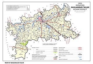
Nanjangud, officially known as Nanjanagudu, is a town in the Mysuru district of Indian state of Karnataka. Nanjangud lies on the banks of the river Kapila, 23 km from the city of Mysore. Nanjangud is famous for the Srikanteshwara Temple located here. Nanjangud is also called Dakshina Kashi. This town is also famous for a type of banana grown in the region called the Nanjanagoodu rasabale. Nanjangud's local administrative unit was designated as a Municipal Committee in 2015 by including Devirammanahalli and Kallahalli village.

Kalyandurg is a town in Anantapur district of the Indian state of Andhra Pradesh. It is the headquarters for Kalyandurg mandal and Kalyandurg revenue division. The discovery of diamond-bearing Kimberlites in Kalyandurg area, is one of the clusters that has been discovered.
Mulabagilu is a town and taluk headquarters of Mulabagilu taluk in the Kolar district in the state of Karnataka, India. It lies just off the National Highway 75 as the easternmost town of the state and a hill landmark.
Vadamalapeta is a mandal headquarters in Tirupati district of the Indian state of Andhra Pradesh. It is located on the outskirts of the famous Tirupati city. It falls in the jurisdictional limit of Tirupati Urban Development Authority. It is part of Vadamalapeta mandal, which is under the jurisdiction of Tirupati revenue division. Vadamalapeta mandal, along with its villages including Vadamalapeta was made part of the newly formed Tirupati district on 4 April 2022.
Pebbair is now a Municipal corporation and a Municipal corporation in Wanaparthy district in the state of Telangana, India. The Pebbair Municipal corporation extends from Pampuram village in the North to Yaparla village in the south..
Kanathur is a village in Turvekere taluk of Tumkur district, in the Indian state of Karnataka.
Yeswanthanagar is a village in the southern state of Karnataka, India. It is located in the Sandur taluk of Bellary district in Karnataka.
Nagathan is a village in the southern state of Karnataka, India. It is located in the Bijapur taluk of Bijapur district in Karnataka.
Sriramapura is a town in the southern state of Karnataka, India. It is located in the Hosadurga taluk of Chitradurga district in Karnataka.
Towdur is a village in the southern state of Karnataka, India. It can also be spelt as Thoudur, Tavadur or Thouduru. It is located in the Harapanahalli taluk of Bellary district in Karnataka. It is a Grama Panchayat, consisting of 11 villages. The village has mostly farmers, a few middle-class families, and very few rich people. The village consists of 7 main historical temples. Udisalambika Devi Temple and Veeranjaneya temples are the famous among them. Basavanna Temple is like an assembly for the villagers. Villagers assemble here for Important discussions in the name of Panchayat meet. Thoudur owns 1 Government Higher Primary School and Government High school named Ayyanahalli Matada Kadamma Veerayya High School land donated by AM Ajjaiah & Kotraiah brothers on remembrance of his Parents.
Marlanahalli is a village in the southern state of Karnataka, India. It is located in the Karatgi taluk of Koppal district in Karnataka.
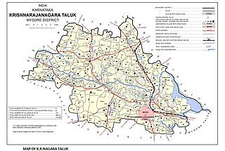
Saligrama [ಸಾಲಿಗ್ರಾಮ] is the fifth biggest Town by area in the sub district and is situated on the north bank of the river Cauvery [Kaveri], this place is esteemed as sacred by the Shri Vaishnavas on account of its having been the residence of Sri Ramanujacharya. It is a hobli and taluk headquarters of the Saligrama Taluk. it was established as a new taluk carving out of K.R.Nagar taluk with effect from 31.12.2020 and become ninth taluk of Mysore district of Karnataka, India.
Utkur or Utkoor is a Mandal in Narayanpet district, Telangana.
Dhanwada or Dhanvada is a mandal in the Narayanpet district of Telangana, India. This mandal is part of the Narayanapet Assembly Constituency and the Mahbubnagar Loksabha Constituency.
Bheema lift irrigation project or Rajiv Bheema Project is a lift irrigation canal project located in Narayanpet district in Telangana, India. Water is lifted at Panchdev Pahad from the back waters of Jurala Dam. Under the same project, another lift canal originates separately from the Ramanpahad balancing reservoir under Jurala left bank to irrigate the uplands.
Makthal Assembly constituency is a constituency of Telangana Legislative Assembly, India. It is one among 14 constituencies in Mahbubnagar district. It is part of Mahbubnagar Lok Sabha constituency.
The Telangana State Tourism Development Corporation is a state government agency which promotes tourism in Telangana, a state in the Southern region of India. The retired Director General of Police Pervaram Ramulu is the appointed First chairman of Telangana State Tourism. Tourist attractions in Telangana include historical places, monuments, forts, water falls, forests and temples.
Mahabubabad district is a district in the Indian state of Telangana. The district was carved out from the erstwhile Warangal district following the re-organisation of districts in the state in October 2016. The district shares boundaries with Suryapet, Khammam, Bhadradri, Warangal, Mulugu and Jangaon districts.

Chandraspalle is a small village in Koilkonda Mandal, Narayanpet constituency, Mahabubnagar district, Telangana in southern India. It is located 26 kilometres towards west from the district headquarters in Mahabubnagar, and is five kilometres from Mandal Koilkonda and 125 kilometres from Hyderabad.
Kalwakurthy is a city and revenue division in Nagarkurnool district of Telangana, India. It is the second largest town in Nagarkurnool district after Nagarkurnool by area.And also it is one of the major cities in combined mahbubunagar district.It is located 80 km from Hyderabad on the Srisailam highway as well as on the Kodada to Jadcherla highway. It is around 31.7 km from the district headquarters of Nagarkurnool.

