
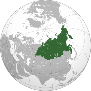
Russia is the largest country in the world, covering over 17,125,192 km2, and encompassing more than one-eighth of Earth's inhabited land area. Russia extends across eleven time zones, and has the most borders of any country in the world, with sixteen sovereign nations.

Siberia is an extensive geographical region, constituting all of North Asia, from the Ural Mountains in the west to the Pacific Ocean in the east. It has been a part of Russia since the latter half of the 16th century, after the Russians conquered lands east of the Ural Mountains. Siberia is vast and sparsely populated, covering an area of over 13.1 million square kilometres (5,100,000 sq mi), but home to merely one-fifth of Russia's population. Novosibirsk, Omsk, and Chelyabinsk are the largest cities in the region.

The Ural Mountains or simply the Urals, are a mountain range in Eurasia that runs north-south mostly through Russia, from the coast of the Arctic Ocean to the river Ural and northwestern Kazakhstan. The mountain range forms part of the conventional boundary between the regions of Europe and Asia. Vaygach Island and the islands of Novaya Zemlya form a further continuation of the chain to the north into the Arctic Ocean. The average altitudes of the Urals are around 1,000–1,300 metres (3,300–4,300 ft), the highest point being Mount Narodnaya, which reaches a height of 1,894 metres (6,214 ft).

Sakha, officially the Republic of Sakha (Yakutia), is the largest republic of Russia, located in the Russian Far East, along the Arctic Ocean, with a population of roughly 1 million. Sakha comprises half of the area of its governing Far Eastern Federal District, and is the world's largest country subdivision, covering over 3,083,523 square kilometers (1,190,555 sq mi). Yakutsk, which is the world's coldest major city, is its capital and largest city. The republic has a reputation for an extreme and severe climate, with the lowest temperatures in the Northern Hemisphere being recorded in Verkhoyansk and Oymyakon, and regular winter averages commonly dipping below −35 °C (−31 °F) in Yakutsk. The hypercontinental tendencies also result in warm summers for much of the republic.

Krasnoyarsk Krai is a federal subject of Russia, with its administrative center in the city of Krasnoyarsk, the third-largest city in Siberia. Comprising half of the Siberian Federal District, Krasnoyarsk Krai is the largest krai in the Russian Federation, the second largest federal subject and the third largest subnational governing body by area in the world, after Sakha and the Australian state of Western Australia. The krai covers an area of 2,339,700 square kilometers (903,400 sq mi), which is nearly one quarter the size of the entire country of Canada, constituting roughly 13% of the Russian Federation's total area and containing a population of 2,828,187, or just under 2% of its population, per the 2010 Census.
North Asia or Northern Asia, also referred to as Siberia, is the northern region of Asia, which is defined in geographical terms and is coextensive with the Asian part of Russia, and consists of three Russian regions east of the Ural Mountains: Ural, Siberia, and the Russian Far East. North Asia is bordered by the Arctic Ocean to its north; by Eastern Europe to its west; by Central and East Asia to its south; and by the Pacific Ocean and North America to its east. It covers an area of 13,100,000 square kilometres (5,100,000 sq mi), or 8.8% of Earth's total land area; and is the largest subregion of Asia by area, but is also the least populated, with a population of around 33 million, accounting for merely 0.74% of Asia's population.

The Lena is the easternmost of the three great Siberian rivers that flow into the Arctic Ocean. Permafrost underlies most of the catchment, 77% of which is continuous. It is 4,294 km (2,668 mi) long, and has a drainage basin of 2,490,000 km2 (960,000 sq mi). The Lena is the eleventh-longest river in the world, and the longest river entirely within Russia.

The East Siberian Sea is a marginal sea in the Arctic Ocean. It is located between the Arctic Cape to the north, the coast of Siberia to the south, the New Siberian Islands to the west and Cape Billings, close to Chukotka, and Wrangel Island to the east. This sea borders on the Laptev Sea to the west and the Chukchi Sea to the east.
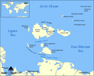
The New Siberian Islands are an archipelago in the Extreme North of Russia, to the north of the East Siberian coast between the Laptev Sea and the East Siberian Sea north of the Sakha (Yakutia) Republic.

New Siberia is the easternmost of the Anzhu Islands, the northern subgroup of the New Siberian Islands lying between the Laptev Sea and East Siberian Sea. Its area of approximately 6,200 square kilometres places it the 102nd largest islands in the world. New Siberia Island is low lying, rising to only 76 metres and covered with tundra vegetation. The island is a part of the territory of Yakutia, Russia.

The Yana is a river in Sakha in Russia, located between the Lena to the west and the Indigirka to the east.

Lake Khövsgöl is the largest freshwater lake in Mongolia by volume and second largest by area. It is located near the northern border of Mongolia, about 200 km west of the southern end of Lake Baikal. It is nicknamed the "Younger sister" of those two "sister lakes".

Eduard Gustav Freiherr von Toll, better known in Russia as Eduard Vasilyevich Toll and often referred to as Baron von Toll, was a Russian geologist and Arctic explorer. He is most notable for leading the Russian polar expedition of 1900–1902 in search of the legendary Sannikov Land, a phantom island purported to lie off Russia's Arctic coast. During the expedition, Toll and a small party of explorers disappeared from Bennett Island, and their fate remains unknown to this day.

The Siberian musk deer is a musk deer found in the mountain forests of Northeast Asia. It is most common in the taiga of southern Siberia, but is also found in parts of Mongolia, Inner Mongolia, Manchuria and the Korean peninsula.

The geology of Russia, the world's largest country, which extends over much of northern Eurasia, consists of several stable cratons and sedimentary platforms bounded by orogenic (mountain) belts.

Pribaikalsky National Park covers the southwest coast of Lake Baikal in southeastern Siberia. The coastal strip includes the lake-facing slopes of the Primorsky Range to the west, as well as offshore islands such as Olkhon Island to the east. It is about 50 km southeast of the city of Irkutsk, Irkutsk Oblast. The park is managed with three other nature reserves, and is a major component of the UNESCO World Heritage Site "Lake Baikal". The Angara River, which is the outflow of Lake Baikal west into the Yenisei River basin, runs through the park. The park has very high levels of biodiversity and endemic species.
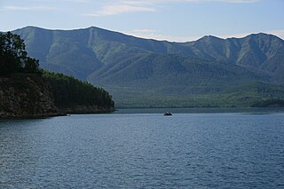
Zaybaykalsky National Park covers the middle section of the eastern shore of Lake Baikal, the west slope of the Barguzin mountains to the east, the Ushkany Islands, and the only large peninsula on the lake, Svyatoy Nos. Of the 2,690 km2 (1,040 sq mi) of the park, 38.8 km2 are protected water areas of the lake itself.
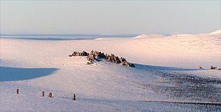
Kigilyakh or kisiliyakh are tall, pillar-like natural rock formations looking like tall monoliths standing more or less isolated. Usually they are composed of granite or sandstone shaped as a result of cryogenic weathering. Most kigilyakhs formed during the Cretaceous period and are about 120 million years old.

The Great Russian Regions are eight geomorphological areas in the Russian Federation displaying characteristic forms of relief. Seven of them are east of the Urals.
