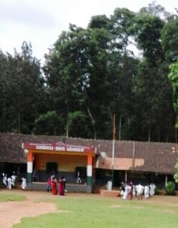
Maldare

Last updated

Maldare
Maldare school, Piriyapatna.jpg
Nickname: 
Maldare school
Coordinates: 12°19′19″N75°56′57″E / 12.32189°N 75.94917°E / 12.32189; 75.94917 Coordinates: 12°19′19″N75°56′57″E / 12.32189°N 75.94917°E / 12.32189; 75.94917
CountryFlag of India.svg  India
State Karnataka
District Kodagu
Time zone UTC+5:25 (IST)
PIN
571253

Maldare is a small village in Kodagu district of Karnataka state, India.

Contents

Location

Maldare is located on the forest road between Piriyapatna and Siddapura. [1]

Distance

Madikeri, 31 km Virajpet, 26 km Mangalore, 175 km Bangalore, 223 km

Post Office

There is a post office at Maldare village. The pincode is 571523. [2]

Suburbs and villages

Demographics

The village of Maldare has a population of 2,027 and there are a total of 525 houses. The people here speak Kannada, Kodava thakk and Malayalam. [3]

Schools

Ekalavya Vasathi School Balugodu St Annes School Minority School

Related Research Articles

<span class="mw-page-title-main">Kodagu district</span> District of Karnataka in India

Kodagu is an administrative district in the Karnataka state of India. Before 1956, it was an administratively separate Coorg State, at which point it was merged into an enlarged Mysore State.

<span class="mw-page-title-main">Tadiandamol</span>

Tadiandamol or Thadiyandamol is the highest mountain of Madikeri taluk Kodagu district, Karnataka, India. It is the third highest peak in Karnataka, after Mullayyanagiri & Kudremukha. It is located Western Ghats range, and reaches an elevation of 1,748 m. The mountain has patches of shola forests in the valleys.

The town of Virajpet also spelled as Virajapete is the second town of the district of Kodagu (Coorg), in Karnataka. It is the main town of the Virajpet taluka, south of the district, in the Kerala-Karnataka border. The name is an abbreviation of Virarajendrapete after the former ruler of Kodagu, Virarajendra.

<span class="mw-page-title-main">Gonikoppal</span> Town in Karnataka, India

Gonikoppal is a census town in the Kodagu district of the Indian state of Karnataka.

<span class="mw-page-title-main">Hunsur</span> Town in Karnataka, India

Hunsur is a city in Mysore district in the Indian state of Karnataka. It is the headquarters of the Hunsur Taluk administrative division.

<span class="mw-page-title-main">Bhagamandala</span> Village in Karnataka, India

Bhagamandala is a pilgrimage place in Kodagu district of the Indian state of Karnataka.

<span class="mw-page-title-main">Irupu Falls</span> Waterfall in Karnataka, India

The Irupu Falls are located in the Brahmagiri Range in the Kodagu district of Karnataka, India, bordering the Wayanad district of Kerala. It is a fresh water cascade and is situated at a distance of 48 km from Virajpet on the highway to Nagarhole. The Falls are also known as the Lakshmana Tirtha Falls, derived from the name of the tributary of Cauvery which starts from these falls, the Lakshmana Tirtha River.

Badagabanangala is a village in the southern state of Karnataka, India. It is located in the Virajpet taluk of Kodagu district in Karnataka.

Channayan Kote is a village in the southern state of Karnataka, India. It is located in the Virajpet taluk of Kodagu district.

Halligattu is a village in the southern state of Karnataka, India. It is located in the Virajpet taluk of Kodagu district.

Kaikeri is a village in the southern state of Karnataka, India. It is located in the Virajpet taluk of Kodagu district.

Rudraguppe is a village in the southern state of Karnataka, India. It is located in the Virajpet taluka of Kodagu district.

<span class="mw-page-title-main">Aimangala, Virajpet</span> Village in Karnataka, India

Aimangala, Virajpet is a village in the southern state of Karnataka, India. It is located in the Virajpet taluk of Kodagu district in Karnataka. It belongs to Mysore Division. It is located 29 KM towards South from District head quarters Madikeri. 10 KM from Virajpet. 247 KM from State capital Bangalore.

<span class="mw-page-title-main">Siddapura, Kodagu</span> Place in Karnataka, India

Siddapur or Siddapura is a village in Kodagu district, Karnataka, in India. It is situated in a coffee growing region near the river Kaveri.

<span class="mw-page-title-main">Appachu Ranjan</span> Indian politician

M. P Appachu Ranjan is an Indian politician who was the former Minister for Youth Services and Sports in Karnataka, a state in Southern India. He is a leader of the BJP in Karnataka and a fifth time Member of the Karnataka Legislative Assembly from Madikeri Constituency in Kodagu district, Karnataka. He belongs to the Kodava Hindu community.

<span class="mw-page-title-main">Nalvathoklu</span> Place in Karnataka, India

Nalvathoklu is a small village in Kodagu district of Karnataka state in India.

<span class="mw-page-title-main">Bittangala</span> Place in Karnataka, India

Bittangala is a small village in Kodagu district of Karnataka state, India.

<span class="mw-page-title-main">Pollibetta</span> Place in Karnataka, India

Pollibetta is a small village in Kodagu district of Karnataka state, India.

<span class="mw-page-title-main">Attur, Virajpet</span> Village in Karnataka, India

Atthur is a small village near Gonikoppa in Virajpet Taluk of Kodagu District, Karnataka State, India. It comes under Guhya Panchayath. It belongs to Mysore Division. It is located 37 km (23 mi) towards South from District headquarters Madikeri and 240 km (150 mi) from State capital Bangalore.

<span class="mw-page-title-main">Attur, Somwarpet</span> Village in Karnataka, India

Attur Nallur is a small village in Somwarpet Taluk in Kodagu District of Karnataka State, India. It comes under Attur Nallur Panchayath. It belongs to Mysore Division. It is located 12 km to the east of District headquarters Madikeri. 28 km from Somvarpet and 234 km from state capital Bangalore.

References

  1. "Google Maps".
  2. "Maldare Pin Code, Maldare , Kodagu Map , Latitude and Longitude , Karnataka".
  3. "Maldare Village Population - Virajpet - Kodagu, Karnataka".