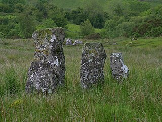
Drumskinny is the site of a stone circle in the townland of Drumskinny, County Fermanagh, Northern Ireland. With the inclusion of an adjacent cairn and alignment, the stone circle is a State Care Historic Monument in Fermanagh and Omagh district, at grid ref: H 2009 7072. The site was excavated in 1962 and is believed to have built around 2000 BC.
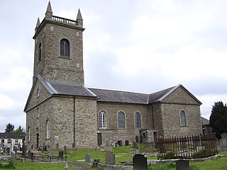
Clogher is a village and civil parish in County Tyrone, Northern Ireland. It lies on the River Blackwater, 18 miles (29 km) south of Omagh. It stands on the townlands of Clogher Demesne and Clogher Tenements. The United Kingdom Census of 2001 recorded a population of 309. The civil parish of Clogher covers areas of County Fermanagh as well as County Tyrone.

Laragh is a townland of 132 acres in County Fermanagh, Northern Ireland. It is situated in the civil parish of Trory and the historic barony of Tirkennedy. It is near Enniskillen Airport.
Trory is a townland, small village and civil parish in County Fermanagh, Northern Ireland, 3 miles (5 km) north of Enniskillen. The townland is situated in the historic barony of Tirkennedy, but the civil parish covers areas of the barony of Tirkennedy, as well as the barony of Lurg. In the 2001 Census it had a population of 315 people. It lies within the Fermanagh and Omagh District Council area.

Kinawley or Kinawly is a small village, townland and civil parish in County Fermanagh, Northern Ireland. The village and townland are both in the civil parish of Kinawley in the historic barony of Clanawley, while other areas of the parish are in the baronies of Knockninny in County Fermanagh and Tullyhaw in County Cavan. In the 2011 Census it had a population of 141 people.

Lack is a small village and townland in County Fermanagh, Northern Ireland, 5.5 km east-north-east of Ederny. It is situated in the civil parish of Magheraculmoney and the historic barony of Lurg. It had a population of 111 people in the 2011 Census..
Tamlaght is a townland and village in County Fermanagh, Northern Ireland, 4.5 km south-east of Enniskillen. It is situated in the civil parish of Derryvullan and the historic barony of Tirkennedy. In the 2001 Census it had a population of 276 people.
Teemore is a townland in County Fermanagh, Northern Ireland, three miles south of Derrylin. In the 2001 Census it had a population of four hundred people. It is situated within the Fermanagh and Omagh District Council area.
Clogherbog is a townland in County Fermanagh, Northern Ireland. It is part of the civil parish of Boho, and contains the sub-townlands of Carrickrory, Lough Nacloyduff, Loughanquin, Loughnamanfin and Tullylaur. It is situated within Fermanagh and Omagh district.

Tomregan is a civil parish in the ancient barony of Tullyhaw. The parish straddles the international border between the Republic of Ireland and Northern Ireland. The largest population centre in the parish is Ballyconnell, County Cavan. The total area of the civil parish is 10,600 statute acres. Most of Tomregan's constituent townlands are situated in County Cavan while the remainder lie in County Fermanagh. In the Catholic Church, the ecclesiastical parish of Tomregan was split in the early 18th century, with the County Fermanagh townlands being assigned to the parish of Knockninny while the County Cavan townlands were united with the parish of Kildallan.
Tattykeeran is a townland of 459 acres in County Fermanagh, Northern Ireland. It is situated in the civil parish of Aghavea and the historic barony of Magherastephana.
Knocks is a townland to the east of Lisnaskea in County Fermanagh, Northern Ireland. It is situated in the historic barony of Magherastephana and the civil parish of Aghalurcher and covers an area of 193 acres.
Ballaghgee Glebe is a townland of 334 acres in County Fermanagh, Northern Ireland. It is situated in the civil parish of Belleek and the historic barony of Lurg.
Derrynacrannog Glebe is a townland of 1,051 acres in County Fermanagh, Northern Ireland. It is situated in the civil parish of Belleek and the historic barony of Lurg.
Eagle island is a townland of one acre in County Fermanagh, Northern Ireland. It is situated in the civil parish of Belleek and the historic barony of Lurg.
Oughterdrum is a townland of 125 acres in County Fermanagh, Northern Ireland. It is situated in the civil parish of Belleek and the historic barony of Lurg.
Tullychurry is a townland of 521 acres in County Fermanagh, Northern Ireland. It is situated in the civil parish of Belleek and the historic barony of Lurg.
Tawnaghgorm is a townland of 162 acres in County Fermanagh, Northern Ireland. It is situated in the civil parish of Belleek and the historic barony of Lurg.