See also
Coordinates: 13°16′32″N144°44′36″E / 13.27556°N 144.74333°E
| | This Guam location article is a stub. You can help Wikipedia by expanding it. |
Malojloj is a census-designated place located within the larger village of Inarajan, in the United States territory of Guam. It is specifically located within the hills north of the central Inarajan.
Coordinates: 13°16′32″N144°44′36″E / 13.27556°N 144.74333°E
| | This Guam location article is a stub. You can help Wikipedia by expanding it. |

Apra Harbor, also called Port Apra, is a deep-water port on the western side of the United States territory of Guam. The harbor is formed by Orote Peninsula in the south and Cabras Island in the north. To the south, the harbor narrows and then widens again to form an inner harbor. The southern end of the harbor is the location of Naval Base Guam. The northern end is the commercial Port of Guam, which more than 90% of civilian cargo imported to Guam. It is considered one of the best natural ports in the Pacific and attracts many tourists.

Agat is a village in the United States territory of Guam. It is located south of Apra Harbor on the island's western shore. The village's population has decreased since the island's 2000 census.

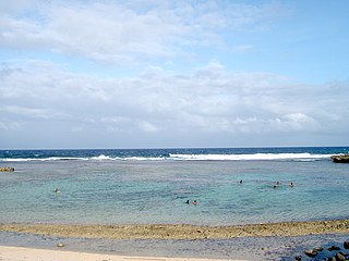
Ipan is a rural beachside community located in the village of Talofofo on the east coast of the United States Territory of Guam. Ipan is a census-designated place in Guam. Ipan contains two beach resorts: Jeff's Pirates Cove and Ipan Beach Resort. Ipan Park is a popular location for family barbecues and parties.

Asan is a village located on the western shore of the United States territory of Guam. The municipality of Asan-Maina combines Asan with Maina, a community in the hills to the east. It was a primary landing site for United States Marines during Guam's liberation from the Japanese during World War II. Asan Beach Park is part of the War in the Pacific National Historic Park. Asan and Maina are located in the Luchan (Western) District.

Santa Rita is a village located on the southwest coast of the United States territory of Guam with hills overlooking Apra Harbor. According to the 2000 census it has a population of 7,500, down from 11,857 in 1990. Santa Rita is the newest village in Guam, having been established after the Second World War.

Piti is a village located on the western shore of the United States territory of Guam. It contains the commercial Port of Guam at Apra Harbor as well as several of the island's largest power plants. NAVFAC Marianas is located there.

Yona is a village in the United States territory of Guam.

Agana Heights is one of the nineteen villages in the United States territory of Guam. It is located in the hills south of Hagåtña, in the central part of the island. United States Naval Hospital Guam is located in this largely residential village.

Umatac, formerly called Umata, is a village on the southwestern coast of the United States territory of Guam. The month of March in the Chamorro language is "Umatalaf," or "to catch guatafi," which is believed to be the root word of Umatac. The village's population has decreased since the island's 2000 census.

Sinajana is the smallest of the nineteen villages in the United States territory of Guam by area. It is located in the hills south of Hagåtña. The village's name may have come from the word "china-jan," cookware used to cook wild yams that once grew in the area.

Mongmong-Toto-Maite is a municipality in the United States territory of Guam composed of three separate villages east of Hagåtña that experienced development after the Second World War.
The area code 671 is the local telephone area code of the United States territory of Guam. It was created with the beginning of permissive dialing on July 1, 1997, replacing Guam's previous International Telecommunication Union country code 671, at the end of permissive dialing on July 1, 1998.
Aga Point is the southernmost point on the main island of Guam. It is located between the villages of Merizo and Inarajan. The only parts of Guam further south are Cocos Island and parts of its surrounding Merizo Barrier Reef.

Talofofo is a village located in the southern part of the United States territory of Guam, on the east coast. The village center is located in the hills above the coast, while the smaller coastal community below the cliff is known as Ipan.

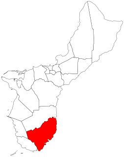
Inarajan is a village located on the southeastern coast of the United States territory of Guam. The village's original Chamoru name, Inalåhan, was altered when transliterated during Spanish control of the island.

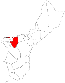
Yigo, Guam is the northernmost village of the United States territory of Guam, and is the location of Andersen Air Force Base. The municipality of Yigo is larger than any other village on the island in terms of area. It contains a number of populated places, including Asatdas and Agafo Gumas.

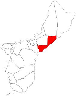
Chalan Pago-Ordot is a municipality in the United States territory of Guam, containing the villages of Chalan-Pago and Ordot. It is located in the eastern-central part of the island and is part of the Kattan (Eastern) District. The village's population has increased slightly following the island's 2000 census.

Barrigada is a village in the United States territory of Guam. A largely residential municipality, its main village is located south of the Antonio B. Won Pat International Airport near the intersections of Routes 8, 10, and 16. The community east of the airport known as Barrigada Heights is considered an affluent neighborhood on the island, where homes have excellent views overlooking much of Guam including the island's airport and hotels along Tumon Bay. Another significant location is Mount Barrigada, nearly 200 meters above sea level. Its location in the center of the island means it houses most of the island's radio masts and towers; the position and height make it easier for radio signals to reach the entire island.

Merizo, is the southernmost village in the United States territory of Guam. Cocos Island is a part of the municipality. The village's population has decreased since the island's 2000 census.

Mangilao is a village on the eastern shore of the United States territory of Guam. The village's population has increased slightly following the island's 2000 census.