Related Research Articles

Guam is an organized, unincorporated territory of the United States in the Micronesia subregion of the western Pacific Ocean. Guam's capital is Hagåtña, and the most populous village is Dededo. It is the westernmost point and territory of the United States, reckoned from the geographic center of the U.S.. In Oceania, Guam is the largest and southernmost of the Mariana Islands and the largest island in Micronesia.
The history of Guam starts with the early arrival around 2000 BC of Austronesian people known today as the Chamorro Peoples. The Chamorus then developed a "pre-contact" society, that was colonized by the Spanish in the 17th century. The present American rule of the island began with the 1898 Spanish–American War. Guam's history of colonialism is the longest among the Pacific islands.

Guam is a U.S. territory in the western Pacific Ocean, at the boundary of the Philippine Sea. It is the southernmost and largest member of the Mariana Islands archipelago, which is itself the northernmost group of islands in Micronesia. The closest political entity is the Commonwealth of the Northern Mariana Islands (CNMI), another U.S. territory. Guam shares maritime boundaries with CNMI to the north and the Federated States of Micronesia to the south. It is located approximately one quarter of the way from the Philippines to Hawaii. Its location and size make it strategically important. It is the only island with both a protected harbor and land for multiple airports between Asia and Hawaii, on an east–west axis, and between Papua New Guinea and Japan, on a north–south axis.

The demographics of Guam details an array of demographic statistics relating to the territory of Guam. This includes statistics on population, including the Indigenous population; religious affiliations; language; and immigration. The Demographics of Guam provides an overview of the history of Guam, as well as a depiction of the villages in the United States territory and its populace. The population of Guam, as of July 2021 was 168,801.

Micronesia is a subregion of Oceania, consisting of about 2,000 small islands in the Northwestern Pacific Ocean. It has a close shared cultural history with three other island regions: Maritime Southeast Asia to the west, Polynesia to the east, and Melanesia to the south—as well as with the wider community of Austronesian peoples.

The Mariana Islands are a crescent-shaped archipelago comprising the summits of fifteen longitudinally oriented, mostly dormant volcanic mountains in the northwestern Pacific Ocean, between the 12th and 21st parallels north and along the 145th meridian east. They lie south-southeast of Japan, west-southwest of Hawaii, north of New Guinea and east of the Philippines, demarcating the Philippine Sea's eastern limit. They are found in the northern part of the western Oceanic sub-region of Micronesia, and are politically divided into two jurisdictions of the United States: the Commonwealth of the Northern Mariana Islands and, at the southern end of the chain, the territory of Guam. The islands were named after the influential Spanish queen Mariana of Austria following their colonization in the 17th century.

Territories of the United States are sub-national administrative divisions overseen by the federal government of the United States. The various American territories differ from the U.S. states and Indian reservations as they are not sovereign entities. In contrast, each state has a sovereignty separate from that of the federal government and each federally recognized Native American tribe possesses limited tribal sovereignty as a "dependent sovereign nation". Territories are classified by incorporation and whether they have an "organized" government through an organic act passed by the Congress. American territories are under American sovereignty and, consequently, may be treated as part of the United States proper in some ways and not others. Unincorporated territories in particular are not considered to be integral parts of the United States, and the Constitution of the United States applies only partially in those territories.

Apra Harbor, also called Port Apra, is a deep-water port on the western side of the United States territory of Guam. It is considered one of the best natural ports in the Pacific Ocean. The harbor is bounded by Cabras Island and the Glass Breakwater to the north and the Orote Peninsula in the south. Naval Base Guam and the Port of Guam are the two major users of the harbor. It is also a popular recreation area for boaters, surfers, scuba divers, and other recreationalists.

Cocos Island is an island 1 mile (1.6 km) off the southern tip of the United States territory of Guam, located within the Merizo Barrier Reef, part of the municipality of Merizo. The island is uninhabited, 1,600 meters (5,200 ft) long in a southwest–northeast direction, between 200 m (660 ft) and 300 m (980 ft) wide, and has an area of 386,303 m2. It sits atop the southwestern coral reef rim of Cocos Lagoon.

Sarigan is an uninhabited volcanic island in the Pacific Ocean. It is part of the Northern Mariana Islands, a U.S. territory. Sarigan is located 37 kilometers (20 nmi) northeast of Anatahan island, 67 km (36 nmi) south of Guguan and 150 km (81 nmi) north of Saipan, the largest island in the Northern Marianas.
Tumon Bay is a bay in the United States territory of Guam, opening to the Philippine Sea. It is bounded to the north by Two Lovers Point and to the south by Ypao Point. The entirety of the bay falls within the Tumon Bay Marine Preserve, also known as the Tumon Bay Marine Preserve Area (MPA) and Tumon Preserve, one of five marine preserves on Guam. The Preserve measures 4.54 square kilometers and is roughly two miles long. The platform of the fringing reef that separates the open ocean from the lagoon is up to 1,450 feet (440 m) wide. and up to one mile from the shore. The bay is located off of the Tumon area, the tourist center of the island, in the village of Tamuning. The bay is extensively utilized for recreation and fishing.
Cocos Lagoon appears as a small incomplete coral atoll attached to the south-western coast of Guam near the area of the village of Merizo. It stretches about 5.5 km (3.4 mi) east-west and 3.5 km (2.2 mi) north-south, covering an area of more than 10 km2 (3.9 sq mi).

Cabras Island was historically a low-lying finger of land off the coast of Piti, Guam that formed part of the northern protective arm of Apra Harbor. Shortly after the 1944 Battle of Guam it was connected by a causeway to the mainland and extended by the Glass Breakwater, and is now typically referred to simply as Cabras. Cabras houses both the Port of Guam and the primary Guam Power Authority generators supplying Guam. It lends its name to both a small vessel Cabras Marina, near the mainland, and the large vessel Cabras Channel, connecting the port to the deeper waters of the middle harbor.

Cycas micronesica is a species of cycad found on the island of Yap in Micronesia, the Marianas islands of Guam and Rota, and The Republic of Palau. It is commonly known as federico nut or fadang in Chamorro. The species, previously lumped with Cycas rumphii and Cycas circinalis, was described in 1994 by Ken Hill. Paleoecological studies have determined that C. micronesica has been present on the island of Guam for about 9,000 years. It is linked with Lytico-Bodig disease, a condition similar to amyotrophic lateral sclerosis (ALS), due to the neurotoxin BMAA found in its seeds, which were a traditional food source on Guam until the 1960s. The neurotoxin is present due to its symbiosis with cyanobacteria.
Raymond Stone was a United States Navy officer and Governor of Guam from January 28, 1904 to May 16, 1904. He served in multiple posts in the Navy, including aboard the battleship USS Kearsarge. He was stationed in Guam in the early 1900s, where he became aide to the governor. When William Elbridge Sewell was transported back to California with an intestinal disease, Stone became acting governor. He issued a series of orders limiting drug sale on the island and forcing vendors to lower prices on food and other essential items. After George Leland Dyer became governor, Stone became a judge on the Supreme Court of Guam before returning to the mainland. He would later serve as a liaison to the United States Army, where he oversaw the transfer of Naval prisoners of war from World War I to Army control.
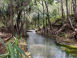
The Ylig River is one of the longest rivers in the United States territory of Guam. Rising close to the west coast some three kilometres north of Apra Heights, it traverses the island, flowing into the sea in the central east coast, south of the town of Yona. The course of this river roughly parallels that of the Pago River, which lies around five kilometres to the north. It runs about 6.83 miles in length, and has a watershed area of 16.08 square miles. The Ylig has two tributaries, the Tarzan and the Manengon rivers.

Rear Admiral Edward Simpson Jr. was a United States Navy officer who briefly served as the acting 20th Naval Governor of Guam from May 8, 1916 to May 30, 1916. Simpson, commandant of the U.S. Naval Base Subic Bay and the U.S. Naval Station Sangley Point, took the position pending the arrival of appointed Governor Captain Roy Campbell Smith. Prior to his command, he served as a naval attaché to London in 1911.
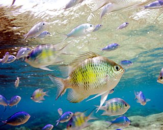
Piti Bomb Holes Marine Preserve is a marine protected area comprising all of Piti Bay on the western coast of Guam, located off of the village of Piti in the Philippine Sea. The defining "bomb hole" features, named because they look like bomb craters in the reef flat, are actually natural percolation pits where fresh water filters into the shallow lagoon at a depth of 25 to 30 feet. The largest pit houses the commercial Fish Eye Marine Park tourist attraction, which includes a wooden pier to a underwater observatory and a Seawalker tour of the lagoon bottom. It is visited by more than 200,000 people annually. The Piti preserve is the most ecologically diverse of Guam's five marine preserves. The pit around Fish Eye is a popular snorkeling and recreational diving site.
An epidemic of smallpox in 1856 on the west Pacific island of Guam, then under the control of Spain, resulted in the death of over half of the population, or about 4,500 people. The population collapse led Spanish authorities to transfer the population of Pago to Hagåtña, ending a settlement dating back before colonization. It also led the Governor of the Spanish Mariana Islands to encourage immigration to Guam.
References
- ↑ Tracey, Joshua. "General Geology of Guam" (PDF). pubs.usgs.gov. USGPO. Retrieved 13 January 2020.
- ↑ Easton, W.H.; Ku, T.L. "Recent Reefs and Shore Lines of Guam 1" (PDF). micronesica.org. Micronesica. Retrieved 13 January 2020.
- ↑ Martin Cox, Leonard (1917). The Island of Guam. Washington: Government Printing Office. p. 66. Retrieved 13 January 2020.
| | This Guam location article is a stub. You can help Wikipedia by expanding it. |