The Upper Peninsulaof Michigan—also known as Upper Michigan or colloquially the U.P. or Yoop—is the northern and more elevated of the two major landmasses that make up the U.S. state of Michigan; it is separated from the Lower Peninsula by the Straits of Mackinac. It is bounded primarily by Lake Superior to the north, separated from the Canadian province of Ontario at the east end by the St. Marys River, and flanked by Lake Huron and Lake Michigan along much of its south. Although the peninsula extends as a geographic feature into the state of Wisconsin, the state boundary follows the Montreal and Menominee rivers and a line connecting them.

Wisconsin is a state in the Great Lakes region of the Upper Midwest of the United States. It borders Minnesota to the west, Iowa to the southwest, Illinois to the south, Lake Michigan to the east, Michigan to the northeast, and Lake Superior to the north. Wisconsin is the 20th-largest state by population and 23rd-largest state by area. It is divided into 72 counties and as of the 2020 census had a population of nearly 5.9 million. Its most populous city is Milwaukee, while its capital and second-most populous city is Madison. Other urban areas include Green Bay, Kenosha, Racine, Eau Claire, and the Fox Cities.
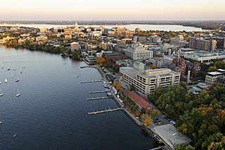
Madison is the capital city of the U.S. state of Wisconsin and the seat of Dane County. The population was 269,840 as of the 2020 census, making it the second-most populous city in Wisconsin, after Milwaukee, and the 77th-most populous in the United States. The Madison metropolitan area had a population of 680,796. The city is located on an isthmus and lands surrounding five lakes—Lake Mendota, Lake Monona, Lake Wingra, Lake Kegonsa and Lake Waubesa. Madison was founded in 1836 and is named after American Founding Father and President James Madison.

Wisconsin has a long history with the Boy Scout and Girl Scout organizations from the 1910s to the present day, both programs have independently served thousands of youth in programs that suit the environment in which they live.

Scouting in Illinois has served youth since 1909. The state was the home of the Boy Scouts of America (BSA) founder, William D. Boyce.

Hurley is a city in and the county seat of Iron County, Wisconsin, United States. The population was 1,558 at the 2020 census. It is located directly across the Montreal River from Ironwood, Michigan.

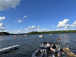
Conover is a town in Vilas County, Wisconsin, United States. The population was 1,235 at the 2010 census. The unincorporated community of Conover is located in the town.

Eagle River is a city in Vilas County, Wisconsin, United States. The population was 1,628 at the 2020 census. It is the county seat of Vilas County. Because of the many lakes in the area, the city is a popular vacation and retirement destination. The area contains many condominiums, seasonal vacation homes, and hunting cabins.

Land o' Lakes is a town in Vilas County, Wisconsin, United States. The population was 861 at the 2010 census. The unincorporated community of Land o' Lakes is located in the town.

The Wisconsin River is a tributary of the Mississippi River in the U.S. state of Wisconsin. At approximately 430 miles long, it is the state's longest river. The river's name was first recorded in 1673 by Jacques Marquette as "Meskousing" from his Indian guides - most likely Miami for "river running through a red place."

Culver Franchising System, LLC, doing business as Culver's, is an American fast-casual restaurant chain. The company was founded in 1984 by George, Ruth, Craig, and Lea Culver. The first location opened in Sauk City, Wisconsin, on July 18, 1984, under the name "Culver's Frozen Custard and ButterBurgers." The privately held company is headquartered in Prairie du Sac, Wisconsin. The chain operates primarily in the Midwestern United States, and has a total of 965 restaurants in 26 states as of October 30, 2024.

The Northern Highland is a geographical region in the north central United States covering much of the northern territory of the state of Wisconsin.

WSAW-TV is a television station in Wausau, Wisconsin, United States, affiliated with CBS and The CW Plus. It is owned by Gray Television alongside low-power Fox affiliate WZAW-LD. The two stations share studios on Grand Avenue/US 51 in Wausau; WSAW-TV's transmitter is located on Rib Mountain.
Lac Vieux Desert is a lake in the United States divided between Gogebic County, Michigan, and Vilas County, Wisconsin. Fed primarily by springs in the surrounding swamps, it is the source of the Wisconsin River, which flows out of its southwest corner. The lake contains a number of small islands, especially in its northeastern lobe, including Draper Island, in Michigan, and Duck Island, in Wisconsin.

Wisconsin, a state in the Midwestern United States, has a vast and diverse geography famous for its landforms created by glaciers during the Wisconsin glaciation 17,000 years ago. The state can be generally divided into five geographic regions—Lake Superior Lowland, Northern Highland, Central Plain, Eastern Ridges & Lowlands, and Western Upland. The southwestern part of the state, which was not covered by glaciers during the most recent ice age, is known as the Driftless Area. The Wisconsin glaciation formed the Wisconsin Dells, Devil's Lake, and the Baraboo Range. A number of areas are protected in the state, including Devil's Lake State Park, the Apostle Islands National Lakeshore, and the Chequamegon–Nicolet National Forest.

Trout Lake is in Vilas County, Wisconsin, near the towns of Boulder Junction and Arbor Vitae, Wisconsin. With a surface area of 6.208 sq mi (16.079 km2) and a volume of 0.058 cu mi (0.240 km3), Trout Lake is one of the largest lakes in Vilas County. It has 16.1 mi (25.9 km) of shoreline, a large portion of which is undeveloped. There are also seven islands within the lake: Miller Island, Zimmerman Island, Haunted Island, Easter Island, Fisk Island, Chocolate Drop Island, and an unnamed island. It is a dimictic oligotrophic lake that supports a large number of sport fish, which has made it a popular angling destination.

The 1918 Illinois Fighting Illini football team was an American football team that represented the University of Illinois during the 1918 Big Ten Conference football season. In their sixth season under head coach Robert Zuppke, the Illini compiled a 5–2 record and tied for the Big Ten Conference championship.

James Frederick Woell, born in Evergreen Park, Illinois in 1934, was an American metalsmith who specialized in found object assemblages in his metal work. He received a degree in economics from the University of Illinois at Urbana-Champaign in 1956, and would later serve in the United States Army for two years. Upon returning to Illinois after his time in the military, Woell went back to Urbana-Champaign to pursue a BFA in art education. It was during this time that Woell was encouraged by his ceramics professor, Don Frith, to take a metals class at the school with metalsmith Robert Von Newman who, at the time, was considered to be one of the best in his field. Woell decided to take the class, and proceeded to enjoy it so much that he would attend the University of Wisconsin-Madison, something Neumann had recommended to him, and received his MFA in metalsmithing in 1962.
The Camille Dreyfus Teacher-Scholar Awards are awards given to early-career researchers in chemistry by The Camille and Henry Dreyfus Foundation, Inc. "to support the research and teaching careers of talented young faculty in the chemical sciences." The Dreyfus Teacher-Scholar program began in 1970. In 1994, the program was divided into two parallel awards: The Camille Dreyfus Teacher-Scholar Awards Program, aimed at research universities, and the Henry Dreyfus Teacher-Scholar Awards Program, directed at primarily undergraduate institutions. This list compiles all the pre-1994 Teacher-Scholars, and the subsequent Camille Dreyfus Teacher-Scholars.
The 1987 Wisconsin–Stevens Point Pointers represented the University of Wisconsin–Stevens Point as a member of the Wisconsin State University Conference (WSUC) during the 1987 NAIA Division II football season. Led by sixth-year head coach D. J. LeRoy, the Pointers finished the season with an overall record of 12–2–1 and a mark of 7–1 in conference play, winning the WSUC title. Wisconsin–Stevens Point advanced to the NAIA Division II Championship playoffs, where the Pointers defeated Westmar in the first round, St. Ambrose in the quarterfinals, and Geneva in the semifinals before tying Pacific Lutheran in the title game.