Plum Lake, Wisconsin

Last updated

Plum Lake, Wisconsin
WIMap-doton-Plum Lake.png
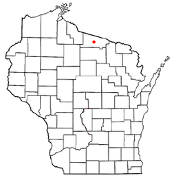
Location of Plum Lake, Wisconsin
Coordinates: 46°1′53″N89°31′13″W / 46.03139°N 89.52028°W / 46.03139; -89.52028
Country Flag of the United States.svg  United States
State Flag of Wisconsin.svg  Wisconsin
County Vilas
Area
  Total100.1 sq mi (259.2 km2)
  Land88.9 sq mi (230.3 km2)
  Water11.1 sq mi (28.8 km2)
Elevation
[1]
1,673 ft (510 m)
Population
 (2000)
  Total486
  Density5.5/sq mi (2.1/km2)
Time zone UTC-6 (Central (CST))
  Summer (DST) UTC-5 (CDT)
Area code(s) 715 & 534
FIPS code 55-63625 [2]
GNIS feature ID1583944 [1]

Plum Lake is a town in Vilas County, Wisconsin, United States. The population was 486 at the 2000 census. The census-designated place of Sayner and the unincorporated community of Star Lake are located in the town.

Contents

Demographics

As of the census [2] of 2000, there were 486 people, 221 households, and 156 families residing in the town. The population density was 5.5 people per square mile (2.1/km2). There were 762 housing units at an average density of 8.6 per square mile (3.3/km2). The racial makeup of the town was 98.35% White, and 1.65% from two or more races.

There were 221 households, out of which 21.7% had children under the age of 18 living with them, 61.1% were married couples living together, 5.4% had a female householder with no husband present, and 29.4% were non-families. 27.6% of all households were made up of individuals, and 12.7% had someone living alone who was 65 years of age or older. The average household size was 2.20 and the average family size was 2.65.

In terms of age the population of the town was spread out, with 19.8% under the age of 18, 2.7% from 18 to 24, 21.4% from 25 to 44, 33.5% from 45 to 64, and 22.6% who were 65 years of age or older. The median age was 48 years. For every 100 females, there were 100.0 males. For every 100 females age 18 and over, there were 98.0 males.

The median income for a household in the town was $33,529, and the median income for a family was $39,519. Males had a median income of $30,795 versus $20,000 for females. The per capita income for the town was $17,824. About 6.8% of families and 7.7% of the population were below the poverty line, including 7.6% of those under age 18 and 11.3% of those age 65 or over.

Geography

The Town of Plum Lake is located in central Vilas County. Much of the town is made up of Vilas County Forest lands or Northern Highland-American Legion State Forest. According to the United States Census Bureau, the town has a total area of 100.1 square miles (259.2 km2), of which, 88.9 square miles (230.3 km2) of it is land and 11.1 square miles (28.8 km2) of it (11.12%) is water.

Transportation

Plum Lake is served by one Wisconsin State Highway and several Vilas County Trunk Highways. Sayner is connected to the rest of the Wisconsin Highway System via STH 155 which runs south to a junction with STH 70 in St. Germain. CTH N runs in two distinct sections through the town. The western section runs west from Sayner serving Northern Highland-American Legion State Forest campgrounds and recreation areas at Crystal Lake, Plum Lake, and Firefly Lake before meeting CTH M and eventually USH 51. This section is often used as a through route for travellers crossing Vilas County as an alternative to STH 70. The eastern section connects Sayner and Star Lake via CTH K, and provides a connection to CTH G and Eagle River. CTH K runs east–west through the town serving the Star Lake area. To the east it runs through mostly Vilas County forest lands to Conover, and to the west CTH K is a Rustic Road between its junction with CTH N and Boulder Junction.

Related Research Articles

<span class="mw-page-title-main">Vilas County, Wisconsin</span> County in Wisconsin, United States

Vilas County is a county in the state of Wisconsin, United States. As of the 2020 census, the population was 23,047. Its county seat is Eagle River. The county partly overlaps the reservation of the Lac du Flambeau Band of Lake Superior Chippewa.

<span class="mw-page-title-main">Taylor County, Wisconsin</span> County in Wisconsin, United States

Taylor County is a county in the U.S. state of Wisconsin. As of the 2020 census, the population was 19,913. Its county seat is Medford. It is mostly rural, lying roughly where corn and dairy farms to the south give way to forest and swamp to the north.

<span class="mw-page-title-main">Oneida County, Wisconsin</span> County in Wisconsin, United States

Oneida County is a county in the state of Wisconsin, United States. At the 2020 census, the population was 37,845. Its county seat is Rhinelander.

<span class="mw-page-title-main">Iron County, Wisconsin</span> County in Wisconsin, United States

Iron County is a county located in the U.S. state of Wisconsin. As of the 2020 census, the population was 6,137, making it the third-least populous county in Wisconsin. Its county seat is Hurley. It was named for the valuable iron ore found within its borders. The county overlaps with small parts of the Bad River and Lac du Flambeau Indian reservations.

<span class="mw-page-title-main">Washington County, Minnesota</span> County in Minnesota, United States

Washington County is a county in the U.S. state of Minnesota. As of the 2020 census, the population was 267,568, making it the fifth-most populous county in Minnesota. Its county seat is Stillwater. The largest city in the county is Woodbury, the eighth-largest city in Minnesota and the fourth-largest Twin Cities suburb.

Angora Township is a township in Saint Louis County, Minnesota, United States. The population was 249 at the 2010 census. Angora Township was named after Angora, in Turkey.

<span class="mw-page-title-main">Caswell, Wisconsin</span> Town in Wisconsin, United States

Caswell is a town in Forest County, Wisconsin, United States. The population was 91 at the 2010 census. The unincorporated communities of Cavour and Laona Junction are located within the town. The ghost town of Bagdad was located in the town.

Arbor Vitae is a town in Vilas County, Wisconsin, United States. The population was 3,153 at the 2000 census. The unincorporated community of Arbor Vitae is located in the town.

Boulder Junction is a town in Vilas County, Wisconsin, United States. The population was 956 at the 2018 census.

<span class="mw-page-title-main">Conover, Wisconsin</span> Town in Wisconsin, United States

Conover is a town in Vilas County, Wisconsin, United States. The population was 1,235 at the 2010 census. The unincorporated community of Conover is located in the town.

<span class="mw-page-title-main">Land o' Lakes, Wisconsin</span> Town in Wisconsin, United States

Land o' Lakes is a town in Vilas County, Wisconsin, United States. The population was 861 at the 2010 census. The unincorporated community of Land o' Lakes is located in the town.

<span class="mw-page-title-main">Phelps, Wisconsin</span> Town in Wisconsin, United States

Phelps is a town in Vilas County, Wisconsin, United States. The population was 1,238 in 2020. The unincorporated community of Phelps is located in the town.

<span class="mw-page-title-main">Presque Isle, Wisconsin</span> Town in Wisconsin, United States

The Town of Presque Isle is located in Vilas County, Wisconsin, United States. The population was reported by the 2020 Census to be 808. The unincorporated communities of Presque Isle and Katinka Village are located in the town.

<span class="mw-page-title-main">Winchester, Vilas County, Wisconsin</span> Town in Wisconsin, United States

Winchester is a town in Vilas County, Wisconsin, United States. The population was 383 at the 2010 census. The unincorporated community of Winchester—locally known as the "Winchester Townsite"—is located in the town.

<span class="mw-page-title-main">Algoma, Winnebago County, Wisconsin</span> Town in Wisconsin, United States

Algoma is a town in Winnebago County, Wisconsin, United States. The population was 6,822 at the 2010 census. The unincorporated communities of Highland Shore, Leonards Point, Melrose Park, and Oakwood are located in the town.

<span class="mw-page-title-main">Stillwater, New York</span> Town in New York, United States

Stillwater is a town in Saratoga County, New York, United States, with a population of 8,287 at the 2010 census. The town contains a village called Stillwater. The town is at the eastern border of the county, southeast of Saratoga Springs and borders both Rensselaer and Washington counties. Saratoga National Historical Park is located within the town's limits. There is a hamlet in Minerva, Essex County, New York, with the same name which has nothing to do with this town.

<span class="mw-page-title-main">Norfolk, New York</span> Town in New York, United States

Norfolk is a town in St. Lawrence County in the U.S. state of New York. The town is in the northern part of the county and is north of Potsdam. The population was 4,453 at the 2020 census.

The Town of Superior is a town in Douglas County, Wisconsin, United States. The population was 2,264 at the 2020 US census, up from 2,058 at the 2000 census. The Village of Superior is located within the town. The City of Superior is located immediately north and adjacent to both the Town of Superior and the Village of Superior.

<span class="mw-page-title-main">Wisconsin Highway 155</span> State highway in Wisconsin, United States

State Trunk Highway 155 is a 6.94-mile (11.17 km) state highway in Vilas County, Wisconsin, United States, that runs north–south from Wisconsin Highway 70 (WIS 70) St. Germain to the northern of two junctions with County Trunk Highway N (CTH‑N) Sayner. The highway is maintained by the Wisconsin Department of Transportation.

Sayner is a census-designated place in the Town of Plum Lake in Vilas County, Wisconsin, United States. It is located at the intersection of Highway 155 and County N, about 15 miles northwest of Eagle River. As of the 2010 census, its population was 207. Sayner has an area of 1.828 square miles (4.73 km2); 1.826 square miles (4.73 km2) of this is land, and 0.002 square miles (0.0052 km2) is water. Sayner got its name from Orrin W. Sayner, who settled the area in 1891, two years before any other settlers took up homes in the town. In 1895, the Milwaukee Road extended its Valley Line north from Woodruff to Star Lake, with a stop in Sayner. The line primarily carried lumber from area forests, later carried tourists and had been abandoned in the middle 20th century.

References

  1. 1 2 "US Board on Geographic Names". United States Geological Survey. October 25, 2007. Retrieved January 31, 2008.
  2. 1 2 "U.S. Census website". United States Census Bureau . Retrieved January 31, 2008.