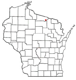
Washington, Vilas County, Wisconsin

Last updated

Washington, Wisconsin
WIMap-doton-Washington h.png
Location of Washington, Vilas County, Wisconsin
Coordinates: 45°56′8″N89°9′12″W / 45.93556°N 89.15333°W / 45.93556; -89.15333
Country Flag of the United States.svg  United States
State Flag of Wisconsin.svg  Wisconsin
County Vilas
Area
  Total47.6 sq mi (123.2 km2)
  Land41.4 sq mi (107.2 km2)
  Water6.1 sq mi (15.9 km2)
Elevation
[1]
1,657 ft (505 m)
Population
 (2000)
  Total1,577
  Density38.1/sq mi (14.7/km2)
Time zone UTC-6 (Central (CST))
  Summer (DST) UTC-5 (CDT)
Area code(s) 715 & 534
FIPS code 55-83750 [2]
GNIS feature ID1584359 [1]

Washington is a town in Vilas County, Wisconsin, United States. The population was 1,577 at the 2000 census.

Contents

Geography

According to the United States Census Bureau, the town has a total area of 47.5 square miles (123.2 km2), of which, 41.4 square miles (107.2 km2) of it is land and 6.2 square miles (15.9 km2) of it (12.93%) is water.

Demographics

As of the census [2] of 2000, there were 1,577 people, 683 households, and 491 families residing in the town. The population density was 38.1 people per square mile (14.7/km2). There were 1,706 housing units at an average density of 41.2 per square mile (15.9/km2). The racial makeup of the town was 98.67% White, 0.19% African American, 0.38% Native American, 0.06% Asian, and 0.70% from two or more races. Hispanic or Latino of any race were 0.32% of the population.

There were 683 households, out of which 24.7% had children under the age of 18 living with them, 63.4% were married couples living together, 5.6% had a female householder with no husband present, and 28.0% were non-families. 23.3% of all households were made up of individuals, and 8.8% had someone living alone who was 65 years of age or older. The average household size was 2.31 and the average family size was 2.71.

In the town, the population was spread out, with 20.4% under the age of 18, 4.8% from 18 to 24, 23.9% from 25 to 44, 31.4% from 45 to 64, and 19.6% who were 65 years of age or older. The median age was 45 years. For every 100 females, there were 101.4 males. For every 100 females age 18 and over, there were 104.6 males.

The median income for a household in the town was $34,961, and the median income for a family was $39,211. Males had a median income of $31,250 versus $22,574 for females. The per capita income for the town was $18,544. About 3.2% of families and 5.7% of the population were below the poverty line, including 4.7% of those under age 18 and 8.1% of those age 65 or over.

Related Research Articles

<span class="mw-page-title-main">Berkley, Iowa</span> City in Iowa, United States

Berkley is a city in Union Township, Boone County, Iowa, United States. The population was 23 at the 2020 census, down 4.2% from 24 in 2000.

<span class="mw-page-title-main">Calumet, Iowa</span> City in Iowa, United States

Calumet is a city in O'Brien County, Iowa, United States. The population was 146 at the 2020 census.

<span class="mw-page-title-main">Baldwin, Maine</span> Town in the state of Maine, United States

Baldwin is a town in Cumberland County, Maine, United States. The population was 1,520 at the 2020 census. It is part of the Portland–South Portland–Biddeford, Maine, metropolitan statistical area.

<span class="mw-page-title-main">Dryden, Michigan</span> Village in Michigan, United States

Dryden is a village in Lapeer County in the U.S. state of Michigan. The population was 951 at the 2010 census. The village is located within Dryden Township.

<span class="mw-page-title-main">Heritage Hills, New York</span> Census-designated place in New York, United States

Heritage Hills is a hamlet (CDP) located in the town of Somers in Westchester County, New York, United States. The population was 3,975 at the 2010 census.

<span class="mw-page-title-main">Dewar, Oklahoma</span> Town in Oklahoma, United States

Dewar is a town in Okmulgee County, Oklahoma, United States. The population was 818 at the 2010 census, a decline of 11.0 percent from the figure of 919 recorded in 2000. Founded in 1909 by workers for the Missouri, Oklahoma and Gulf Railway (MO&G), it was named for William Peter Dewar, a railroad official. It incorporated in 1909.

<span class="mw-page-title-main">Wesleyville, Pennsylvania</span> Borough in Pennsylvania, United States

Wesleyville is a borough in Erie County, Pennsylvania, United States. The population was 3,229 at the 2020 census, down from 3,341 in 2010. It is part of the Erie Metropolitan Statistical Area.

<span class="mw-page-title-main">Spring Brook Township, Lackawanna County, Pennsylvania</span> Place in Pennsylvania, United States

Spring Brook Township is a township in Lackawanna County, Pennsylvania, United States. The population was 2,753 at the 2020 census.

<span class="mw-page-title-main">Great Falls, South Carolina</span> Town in South Carolina, United States

Great Falls is a town in Chester County, South Carolina, United States and is located fourteen miles southwest of Lancaster, South Carolina. The population was 1,951 at the 2020 census.

<span class="mw-page-title-main">Ravinia, South Dakota</span> Town in South Dakota, United States

Ravinia is a town in Charles Mix County, South Dakota, United States. The population was 71 at the 2020 census.

<span class="mw-page-title-main">Payne Springs, Texas</span> Town in Texas, United States

Payne Springs is a town in Henderson County, Texas, United States. The population was 767 at the 2010 census, up from 683 at the 2000 census.

<span class="mw-page-title-main">Matoaka, West Virginia</span> Census-designated place in West Virginia, United States

Matoaka is a census-designated place in Mercer County, West Virginia, United States. The population was 227 at the 2010 census. It is part of the Bluefield, WV-VA micropolitan area which has a population of 107,578. This town is named for Chief Powhatan's daughter Matoaka who was better known by her nickname "Pocahontas". Matoaka became an unincorporated town when it voted to dissolve its charter in May 2018.

<span class="mw-page-title-main">Pine Grove, West Virginia</span> Town in West Virginia, United States

Pine Grove is a town in Wetzel County, West Virginia, United States. The population was 363 at the 2020 census. The community was named for a grove of pine trees near the original town site.

<span class="mw-page-title-main">Jordan, Wisconsin</span> Town in Wisconsin, United States

Jordan is a town in Green County, Wisconsin, United States. The population was 577 at the 2000 census. The unincorporated community of Jordan Center is located in the town.

<span class="mw-page-title-main">Chase, Wisconsin</span> Town in Wisconsin, United States

Chase is a town in Oconto County, Wisconsin The population was 2,082 at the time of the 2000 census. The unincorporated communities of Chase and South Chase are located in the town. The unincorporated community of Krakow is also located partially in the town.

<span class="mw-page-title-main">Coon, Wisconsin</span> Town in Wisconsin, United States

Coon is a town in Vernon County, Wisconsin, United States. The population was 683 at the 2000 census.

<span class="mw-page-title-main">Mazomanie (town), Wisconsin</span>

Mazomanie is a town in Dane County, Wisconsin. The population was 1,185 at the time of the 2000 census. The Village of Mazomanie is located within the town.

<span class="mw-page-title-main">Genoa (town), Wisconsin</span> Human settlement in Vernon County, Wisconsin, United States of America

Genoa is a town in Vernon County, Wisconsin, United States. The population was 705 at the 2000 census. The Village of Genoa is located within the town. The unincorporated community of Romance is located in the town of Genoa.

References

  1. 1 2 "US Board on Geographic Names". United States Geological Survey. October 25, 2007. Retrieved January 31, 2008.
  2. 1 2 "U.S. Census website". United States Census Bureau . Retrieved January 31, 2008.

45°56′46″N89°8′13″W / 45.94611°N 89.13694°W / 45.94611; -89.13694