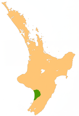
Some of the most fertile land in the southwestern North Island of New Zealand is on the floodplains of the Manawatu and Rangitikei Rivers, in an area known as the Manawatu Plains.
Stretching from the northern Horowhenua around Levin in the south to Marton in the north, this great triangular area of low-lying land extends inland from the South Taranaki Bight almost as far as Ashhurst at the mouth of the Manawatu Gorge, and covers an area of around 1,000 square kilometres (390sqmi).
In the south, around Lake Horowhenua, the plains were once an extensive wetland, which has been largely drained and turned into profitable dairy farming land. There are conservation moves in progress to restore some of these wetlands to their former state.
Further north, the plains provide the basis for the economy which drives the city of Palmerston North and the towns of Foxton, Feilding and Bulls, all of which rely on the agricultural dollar to an extent.
As floodplains, the land is not always entirely dry land, and although the area receives slightly below the national average rainfall, floods can occur, as happened most recently around the township of Tangimoana in early 2004.
With an area of 238,397 km2 (92,046 sq mi), Romania is the twelfth-largest country in Europe. Located in Southeastern Europe, bordering on the Black Sea, the country is halfway between the equator and the North Pole and equidistant from the westernmost part of Europe—the Atlantic Coast—and the most easterly—the Ural Mountains. Romania has 3,195 kilometers of border. Republic of Moldova and Ukraine lie to the east, Bulgaria lies to the south, and Serbia and Hungary to the west. In the southeast, 245 kilometers of sea coastline provide an important outlet to the Black Sea and the Atlantic Ocean.
Manawatū-Whanganui[manawaˈtʉː ˈʔwaŋanʉi]) is a region in the lower half of the North Island of New Zealand, whose main population centres are the cities of Palmerston North and Whanganui. It is administered by the Manawatū-Whanganui Regional Council, which operates under the name Horizons Regional Council.
Horowhenua District is a local government district on the west coast of the North Island of New Zealand. It forms part of the Manawatu-Wanganui Region. Its name roughly means shaking or rippling earth.
The Manawatu District is a local government district in the Manawatu-Wanganui Region in the North Island of New Zealand.
The Taieri Plain is an area of fertile agricultural land to the southwest of Dunedin, in Otago, New Zealand. The plain covers an area of some 300 square kilometres, with a maximum extent of 30 kilometres.
The Hauraki Plains are a geographical feature and non-administrative area located in the northern North Island of New Zealand, at the lower (northern) end of the Thames Valley. They are located 75 kilometres south-east of Auckland, at the foot of the Coromandel Peninsula and occupy the southern portion of a rift valley bounded on the north-west by the Hunua Ranges, to the east by the Coromandel and Kaimai ranges and the west by a series of undulating hills which separate the plains from the much larger plains of the Waikato River. Broadly, the northern and southern parts of the Hauraki Plains are administered by the Hauraki District and the Matamata-Piako District respectively.
The Ruamahanga River runs through the southeastern North Island of New Zealand.
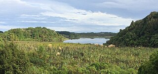
Lake Horowhenua is located in the Horowhenua District, an area of the southern Manawatu-Wanganui region in New Zealand's North Island. It covers an area of 3.9 square kilometres (1.5 sq mi).
Opiki is a small rural settlement in the Horowhenua district of New Zealand's North Island. It is located on the floodplain of the Manawatu River, 15 km (9 mi) southwest of Palmerston North.
Foxton Beach is a small settlement in the Horowhenua District of the Manawatu-Wanganui region of New Zealand's North Island. It is located on the South Taranaki Bight at the mouth of the Manawatu River, 35 kilometres southwest of Palmerston North, and six kilometres west of Foxton. Foxton Beach has a permanent population of around 2000 people. The town is a popular holiday destination due mainly to its beach and the bird sanctuary at the Manawatu Estuary. Most of Foxton Beach is made up of holiday homes.
Te Horo and Te Horo Beach are two localities on the Kapiti Coast of New Zealand's North Island. Te Horo Beach is the larger of the two settlements and, as its name implies, is located on the Tasman Sea coast. Te Horo is located to the east, a short distance inland. They are situated between Peka Peka and Waikanae to the south and Otaki to the north. "Te Horo" in the Māori language means "the landslide".
The Oroua River is a river of the southwestern North Island of New Zealand.
The biomes and ecoregions in the ecology of Zambia are described, listed and mapped here, following the World Wildlife Fund's Global 200 classification scheme for terrestrial ecoregions, and the WWF freshwater bioregion classification for rivers, lakes and wetlands. Zambia is in the Afrotropic biogeographic realm of the scheme. Three terrestrial biomes are well represented in the country . The distribution of the biomes and ecoregions is governed mainly by the physical environment, especially climate.
The Barotse Floodplain also known as the Bulozi Plain, Lyondo or the Zambezi Floodplain is one of Africa's great wetlands, on the Zambezi River in the Western Province of Zambia. It is a designated Ramsar site, regarded as being of high conservation value.
A district in New Zealand is a territorial authority area governed by a district council as a second-tier of local government in New Zealand, below regional councils. They were formed as a result of local government reforms in 1989. There are 53 districts in New Zealand, and they do not include the 13 city councils, and the Chatham Islands Council. District councils serve a combination of rural and urban communities, while city councils administer the larger urban areas. Three districts are unitary authorities also performing the functions of a regional council.
The Edithvale-Seaford Wetlands are a group of two principally freshwater swamps, totalling 261 hectares, lying in the suburbs of Aspendale, Edithvale, Chelsea Heights, and Seaford in south-eastern Melbourne, Victoria, Australia. Together they form the Edithvale-Seaford Wetlands Ramsar Site. With the nearby Eastern Treatment Plant, they form the Carrum Wetlands Important Bird Area.
The Mulga Lands are an interim Australian bioregion of eastern Australia consisting of dry sandy plains with low mulga woodlands and shrublands that are dominated by Acacia aneura (mulga).
Rongotea is a small rural township in the Manawatu District of the Manawatu-Wanganui Region. Located on the western Manawatu Plains, approximately 19 km (12 mi) northwest of the region's main city, Palmerston North.
Lake Papaitonga is located in the Horowhenua, an area of the southern Manawatu-Wanganui region in New Zealand's North Island. Part of the Papaitonga Scenic Reserve, a 135 ha area of forest and wetland, it is the only remaining lake bordered by undisturbed native forest in the Horowhenua region, and contains two populations of endangered native land snails. The traditional home of the Muaūpoko people, the lake was the scene of their massacre and defeat by invading chief Te Rauparaha. The naturalist Walter Buller later managed to purchase Papaitonga and its environs for his country home, which led to its forest being preserved and it eventually becoming a scenic reserve.
Hokio Beach or Hōkio is a village and rural community in the Horowhenua District and Manawatu-Wanganui Region of New Zealand's North Island.
This page is based on this Wikipedia article Text is available under the CC BY-SA 4.0 license; additional terms may apply. Images, videos and audio are available under their respective licenses.