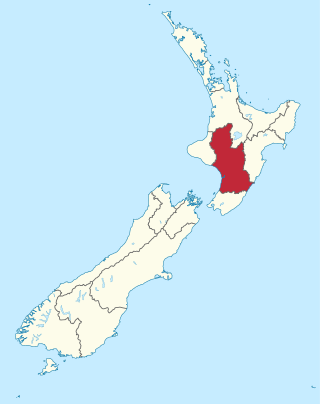
Manawatū-Whanganui is a region in the lower half of the North Island of New Zealand, whose main population centres are the cities of Palmerston North and Whanganui. It is administered by the Manawatū-Whanganui Regional Council, which operates under the name Horizons Regional Council.
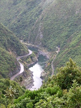
The Manawatū Gorge is a steep-sided gorge formed by the Manawatū River in the North Island of New Zealand. At 6 km (3.7 mi) long, the Manawatū Gorge divides the Ruahine and Tararua Ranges, linking the Manawatū and Tararua Districts. It lies to the northeast of Palmerston North. Its western end is near the small town of Ashhurst and its eastern end is close to the town of Woodville.
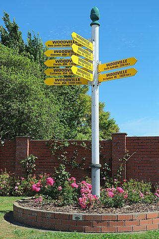
Woodville, previously known as The Junction, is a small town in the southern North Island of New Zealand, 75 km north of Masterton and 25 km east of Palmerston North. The 2013 census showed that 1401 people reside in Woodville.

The Manawatū River is a major river of the lower North Island of New Zealand. The river flows from the Ruahine Ranges, through both the Manawatū Gorge and the city of Palmerston North, and across the Manawatū Plains to the Tasman Sea at Foxton.

Waikanae River is located on the Kāpiti Coast in the North Island of New Zealand.

The Retaruke River is a river in the North Island of New Zealand. It joins with the Whanganui River at Whakahoro just above Wade's Landing and downstream from Taumarunui. The river flows through the farming communities of Upper and then Lower Retaruke Valley. Downstream from this junction is the Mangapurua Landing with its Bridge to Nowhere, servicing the ill-fated Mangapurua Valley farming community.

The Oroua River is a river of the southwestern North Island of New Zealand.

The Mangatainoka River flows in the Tararua District of New Zealand's North Island. Its water was considered so pure a brewery, now the well-known Tui Brewery, was established there.
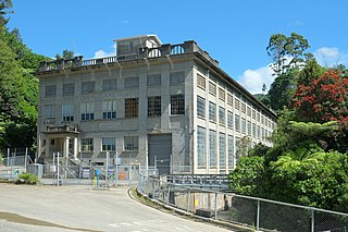
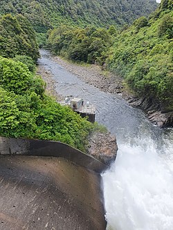
Mangahao Power Station is a hydroelectric power station near the town of Shannon, New Zealand. After being delayed by war, access road construction and foundation testing was started by late 1919 and the station opened in November 1924. It makes use of the Mangahao River, through a series of tunnels and pipelines totalling 4.8 kilometers in the Tararua Ranges. It is jointly owned and operated by Todd Energy and King Country Energy.
The Tokomaru River is a river of the Manawatū-Whanganui Region of the North Island of New Zealand. It rises to the southeast of Shannon and initially flows northeast down a long valley in the Tararua Range before turning northwest to reach the edge of the Manawatū Plain near the town of Tokomaru. From here it turns southwest, reaching the Manawatū River 3 kilometres (2 mi) north of Shannon.
The northern Tiraumea River is a river of the Manawatū-Whanganui region of New Zealand's North Island. The river rises in the rough hill country of the Tararua District, just south of the settlement of Tiraumea. A tributary, Tiraumea Stream, drains the southern end of the Puketoi Range. The river flows west then north to reach the Manawatu River immediately above the highway and Rail bridges, 5 kilometres (3 mi) south of Woodville.
Kakariki railway station was a station on the North Island Main Trunk and in the Manawatū-Whanganui region of New Zealand.
The Mangamaire railway station on the Wairarapa Line was located in the Tararua District of the Manawatū-Whanganui region in New Zealand’s North Island.

The Konini railway station on the Wairarapa Line was located in the Tararua District of the Manawatū-Whanganui region in New Zealand’s North Island.
The Ngawapurua railway station on the Wairarapa Line was located in the Tararua District of the Manawatū-Whanganui region in New Zealand’s North Island.

The Mangatainoka railway station on the Wairarapa Line was located in the Tararua District of the Manawatū-Whanganui region in New Zealand’s North Island.
Papatawa is a rural community in the Tararua District and Manawatū-Whanganui region of New Zealand's North Island. It is located six kilometres north-east of Woodville, on both sides of State Highway 2.
Ballance is a farming community in Tararua District and Manawatū-Whanganui region of New Zealand's North Island. The main settlement is located on the west back of the Mangahao River, south and west of Woodville and 11 km north-west of Pahiatua.
Kumeroa is a farming settlement in Tararua District and Manawatū-Whanganui region of New Zealand's North Island. It is about ten minutes' drive from Woodville, on the opposite side of the Manawatū River.
Makahika is a rural locality in the Horowhenua District of the Manawatū-Whanganui region of New Zealand's North Island. It is located in the Makahika Stream valley. The stream runs southwest from the Tararua Range to join the Ōhau River.