Manawatū-Whanganui is a region in the lower half of the North Island of New Zealand, whose main population centres are the cities of Palmerston North and Whanganui. It is administered by the Manawatū-Whanganui Regional Council, which operates under the name Horizons Regional Council.
Waipukurau is the largest town in the Central Hawke's Bay District on the east coast of the North Island of New Zealand. It is located on the banks of the Tukituki River, 7 kilometres south of Waipawa and 50 kilometres southwest of Hastings.
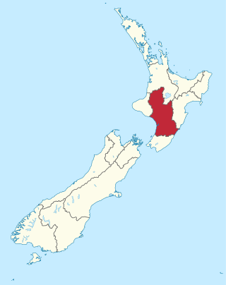
The Tararua District is a district near the south-east corner of New Zealand's North Island that is administered by the Tararua District Council. It has a population of 19,050, and an area of 4,364.65 km². The Tararua District Council was created by the amalgamation of the Dannevirke Borough, Eketahuna County Council, Pahiatua Borough Council, Pahiatua County Council and Woodville District Council in the 1989 local government reforms.

Waipawa is the second-largest town in Central Hawke's Bay in the east of the North Island of New Zealand. It has a population of 2,400.
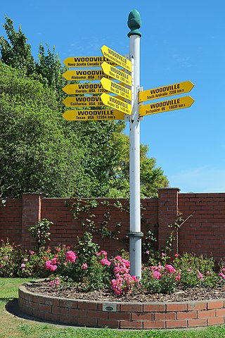
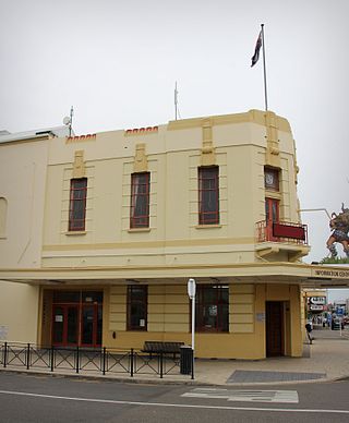
Woodville, previously known as The Junction, is a small town in the southern North Island of New Zealand, 75 km north of Masterton and 25 km east of Palmerston North. The 2013 census showed that 1401 people reside in Woodville.
Bunnythorpe is a village in the Manawatū-Whanganui region of New Zealand's North Island, 10 km (6 mi) north of the region's major city, Palmerston North. Dairy farms predominate the surrounding area but the community facilities include Bunnythorpe School, with a roll of about 80 pupils as of 2010 as well as a Rugby Football Club, Country Club and several manufacturing plants. The population was 687 in the 2018 census.
The Palmerston North–Gisborne Line (PNGL) is a secondary main line railway in the North Island of New Zealand. It branches from the North Island Main Trunk at Palmerston North and runs east through the Manawatū Gorge to Woodville, where it meets the Wairarapa Line, and then proceeds to Hastings and Napier in Hawke's Bay before following the coast north to Gisborne. Construction began in 1872, but the entire line was not completed until 1942. The line crosses the runway of Gisborne Airport, one of the world's only railways to do so since Pakistan's Khyber Pass Railway closed.

The Waitahora Wind Farm was a proposed renewable energy project in New Zealand planned by Contact Energy but which has now been abandoned without construction beginning. This development was proposed to be located on the Puketoi Range which forms one side of the picturesque Waitahora Valley, near Dannevirke in Southern Hawke’s Bay.

William Cowper Smith was a Liberal Party Member of Parliament in New Zealand.

Weber County was one of the counties of New Zealand in the North Island in the former Seventy Mile Bush.

Shannon railway station is a station on the North Island Main Trunk serving Shannon in the Horowhenua District of New Zealand. It is served by the Capital Connection long distance commuter train between Wellington and Palmerston North.
Henry Robert Russell was a notable New Zealand runholder and politician. He was baptised in Dunfermline, Fife, Scotland on 11 February 1817. He was appointed to the New Zealand Legislative Council on 12 July 1862. His membership lapsed on 11 June 1885 after he had been absent for two sessions. He was considered to be the founder of Waipukurau, where he owned the Mount Herbert estate, to the east of the town. His brother, Thomas Purvis Russell, owned the neighbouring Woburn estate and they also owned runs near the Turanganui River in southern Wairarapa. He left an estate of £100,765.

Linton railway station was a flag station at Linton in Palmerston North on the North Island Main Trunk in New Zealand.

Bunnythorpe railway station was a station on the North Island Main Trunk in New Zealand, serving the village of Bunnythorpe.

Mangaonoho railway station was a station on the North Island Main Trunk in New Zealand. For almost a decade, from 1893 to 1902, Mangaonoho was important as the northern terminus of the NIMT's southern section; even a refreshment room was planned. The route north was delayed by construction of major viaducts, the first being Makōhine. To build Makōhine a railway workshop was set up just north of Mangaonoho. Unlike many other NIMT construction camps, Mangaonoho gradually declined after the line was completed. By 1911 the population was down to 167. Decline continued, with removal of the stockyards in 1973 and closure in 1982. There is now only a single line through the former station site.

Silverhope railway station was a station on the North Island Main Trunk in New Zealand, 12 mi 9 ch (19.5 km) from Marton. Goods were first carried to the station on 19 October 1887, though the official opening of the 15 mi 57 ch (25.3 km) Marton to Hunterville section wasn't until Saturday 2 June 1888, when the station was served by two trains a week, reported as losing £15 a week. A Certificate of Inspection for the line was issued on Wednesday, 6 June 1888.

Rata railway station was a station on the North Island Main Trunk in New Zealand, between Marton and Hunterville, 9 mi 46 ch (15.4 km) from Marton. There is now just a single track through the station site, a new crossing loop having replaced those at Rata and Porewa from 14 December 1983, 3.04 km (1.89 mi) to the west of Rata. The realignment of State Highway 1 alongside the railway
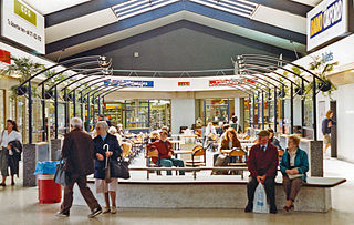
A railway refreshment room is a catering facility attached to a railway station that was formerly common in Britain, Australia, New Zealand, and other countries that were formerly part of the British Empire. They were opened in the 19th century to serve passengers when trains did not convey catering facilities, and thus served passengers en route. Refreshment rooms were similar to tearooms, and generally served a variety of hot drinks, pastries, cakes, and light meals. With the introduction of buffet and restaurant cars, their importance began to decline.
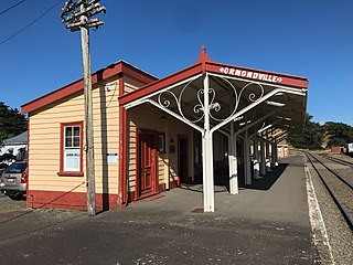
Ormondville is a locality in the Manawatū-Whanganui region of New Zealand's North Island. It is located inland, south of Waipukurau and west of Flemington, Hawke's Bay.
Hatuma is 7 km (4.3 mi) south of Waipukurau, in Central Hawke's Bay in the east of the North Island of New Zealand. Meshblock 7016748, which covers 19.3 km2 (7.5 sq mi) from the edge of Waipukurau to Marakeke, had a population of 153 in 2018.


