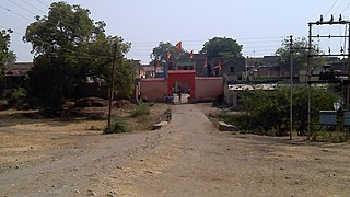
Manegaon is a village and Gram panchayat in Jalgaon Jamod tehsil of Buldhana of Maharashtra. Situated on the right bank of river Purna, it serves as a gateway to Jalgaon Jamodtehsil as one travels from State Highway 196 from Nandura to Jalgaon Jamod. Its location attached to a state highway makes it an important place for other villages in vicinity for transportation to other places. From the British Raj to the recent past, it was popularly known as 8th mile, as it was situated at a distance of eight miles from both Nandura and Jalgaon Jamod.
Manegaon is a small village having a population of 888 individuals with total 211 families as per census 2011.[1] Agriculture is the main occupation of people; however, some brick-making plants on the banks of river Purna and some kiosks on the state highway help the economy a bit.
As of 1976 Gazette, Manegaon has around 2262 Arces of agriculture land and 214 agriculturist in 105 houses. Nandura is nearby railway station and Asalgaon is nearby weekly bazar held on Tuesday. There is a primary School, a temple, a library and Cooperative Society.[2]
Buldhana district is located in the Amravati division of Maharashtra, India . The name of the district is probably derived from Bhil Thana. It is situated at the western border of Vidarbha region and is 500 km away from the state capital, Mumbai. The district has towns and cities like Shegaon, Jalgaon Jamod, Malkapur, Khamgaon, Lonar, Mehkar, and Chikhli. It is surrounded by Madhya Pradesh in the north, Akola, Washim, and Amravati districts on the east, Jalna district on the south, and Jalgaon and Aurangabad districts on the west. Latitudes are 19.51° to 21.17° N and longitudes are 75.57° to 76.59° E. Bounded on the north by Madhya Pradesh state, to the east by Akola and Washim, to the south by Parbhani and Jalna districts, and to the west by Jalna and Jalgaon districts.
Buldhana is the district headquarters and a Municipal Council in the Buldhana District of Amravati division in the Indian State of Maharashtra.
Nandura is a city municipal council in the Buldhana district, Maharashtra, India. It is the headquarters of Nandura taluka and is situated on the National Highway No. 6 and the Mumbai-Howrah railway line. Nandura is an important city in the Buldhana district. The municipality of Nandura was established during the British Raj in 1931. Nandura is famous for 'Khawa'. The place is major supplier of milk products to all nearby area.
Jalgaon Jamod is a town in Buldhana district, in the Indian state of Maharashtra.
Sangrampur is a Nagar Panchayat, a tehsil of Buldhana district, Maharashtra State, India.
Ladnapur is a village in Sangrampur tehsil of Buldhana district, Maharashtra State, India.
Banoda Eklara is a village, in Sangrampur tehsil of Buldhana district, Maharashtra State, India.
Tunki is a town in Sangrampur tehsil of Buldhana district, Maharashtra State, India.
Katel is a village, in Sangrampur tehsil of Buldhana district, Maharashtra State, India.
Warwat Bakal is a Gram Panchayat, in Sangrampur tehsil of Buldhana district, includes in Vidarbha region in the state of Maharashtra, India.
Wadgaon Pr Adgaon is a village, in Sangrampur tehsil of Buldhana district, Maharashtra State, India.
Paturda is a village in Sangrampur tehsil in Buldhana district, Maharashtra state, India.
Kakanwada is a village, in Sangrampur tehsil of Buldhana district of the Indian state of Maharashtra.
Palshi Zashi is a village, in Sangrampur tehsil of Buldhana district, Maharashtra State, India. The day of athavadi bazaar (weekly) of the village is Friday.
Malegaon Bazar is a village, in Telhara tehsil of Akola district, Maharashtra State, India.
Palsoda is a village, in Sangrampur tehsil of Buldhana district, Maharashtra State, India.
Jalamb is a town in Shegaon tehsil of Buldhana district, Maharashtra.
Dhanora, is a village in Jalgaon Jamod tehsil of Buldhana district of Maharashtra, India. It is famous for its fair of Mahasiddha Maharaj. It is also known locally as Dhanora (Mahasiddha) to distinguish it from several other villages named Dhanora.
Khandvi is a village in Jalgaon Jamod tehsil of Buldhana district, Maharashtra.
Maharashtra State Highway 196 is a State Highway running entirely through the Buldhana district of Maharashtra. It connects Motala on State Highway 176 to Khandvi on State Highway 194. It runs through the Motala, Nandura, and Jalgaon Jamod tehsils of the district.
This page is based on this Wikipedia article Text is available under the CC BY-SA 4.0 license; additional terms may apply. Images, videos and audio are available under their respective licenses.