
Mangalore, officially known as Mangaluru, is a major industrial port city in the Indian state of Karnataka and on the west coast of India. It is located between the Laccadive Sea and the Western Ghats about 352 km (219 mi) west of Bangalore, the state capital, 14 km north of Karnataka–Kerala border and 297 km south of Goa. Mangalore is the state's only city to have all four modes of transport—air, road, rail and sea. The population of the urban agglomeration was 619,664 according to the 2011 national census of India. It is known for being one of the locations of the Indian strategic petroleum reserves.
Dakshina Kannada district is located in the state of Karnataka in India, with its headquarters in the coastal city of Mangalore. It is part of the larger Tulu Nadu region. The district covers an area nestled in between the Western Ghats to its east and the Arabian Sea to its west. Dakshina Kannada receives abundant rainfall during the Indian monsoon. It is bordered by Udupi district to the north, Chikmagalur district to the northeast, Hassan district to the east, Kodagu to the southeast and Kasaragod district of Kerala to the south. According to the 2011 census of India, Dakshina Kannada district had a population of 2,083,625. It is the only district in Karnataka state to have all modes of transport like road, rail, water and air due to the presence of a major hub, Mangalore. This financial district is also known as the Cradle of Indian banking.

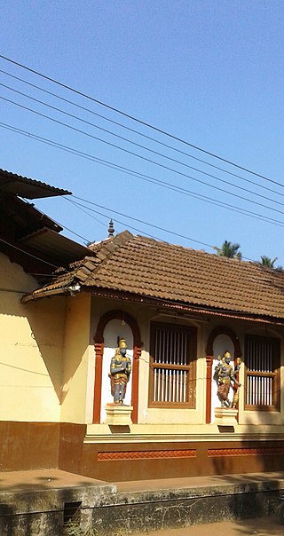
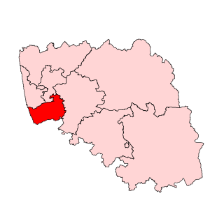
Ullal or Uḷḷāla is a City Municipality at Mangalore, educational, commercial & industrial hub in Dakshina Kannada district. It is located 10 km from the Mangalore City centre. Ullal City Municipality along with the Mangalore City Corporation forms the continuous Mangalore urban agglomeration area which is currently the fourth biggest in Karnataka after Bangalore, Mysore and Hubli-Dharwad. There is also a planning to merge Ullal City Municipality & some gram panchayats along with Mangalore City Corporation to form the Greater Mangalore region. Ullal is one of the oldest towns in India. In the 15th century it came under the rule of the Portuguese. Still the remains of its glorious history can be seen in the beaches and other parts of Ullal.
Bantwal is a suburb of Mangalore in Dakshina Kannada district, Karnataka, India, and the headquarters of Bantwal taluk. It is located 25 km (16 mi) East of Mangalore city center. BC Road-Kaikamba of Bantwal is one of the fastest developing areas in Dakshina Kannada district of Karnataka.

Hassan is a city in the southern part of the Indian state of Karnataka. It is the headquarters of Hassan district. The city is situated midway between Bangalore and Mangalore on National Highway 75.

Udupi district is an administrative subdivision in the Karnataka state of India, with the district headquarters in the city of Udupi. It is situated in the Canara old north malabar coastal region, there are seven taluks, 233 villages and 21 towns in Udupi district. The three northern tehsils of Udupi, Kundapur and Karkala, were partitioned from Dakshina Kannada district to form Udupi district on 25 August 1997. Moodabidri was officially declared as new tehsil (taluk), separated from Karkala with effect from 11 January 2018.
The Government of Karnataka, abbreviated as GoK, or simply Karnataka Government, formerly Government of Mysore, is a democratically elected state body with the governor as the ceremonial head to govern the Southwest Indian state of Karnataka. The governor who is appointed for five years appoints the chief minister and on the advice of the chief minister appoints his council of ministers. Even though the governor remains the ceremonial head of the state, the day-to-day running of the government is taken care of by the chief minister and his council of ministers in whom a great amount of legislative powers are vested.
Talapady is a village near Mangaluru city in Ullal taluk of Dakshina Kannada district of Karnataka state in India. Talapady borders the states of Karnataka and Kerala. National Highway 66 passes through Talapady which is 14 km (9 mi) south of Mangalore city. The Karnataka-Kerala checkpost border is situated at Talapady. Another village Thalapady, Kasargod which is situated near Talapady in Manjeswar crossing Kerala border.
Kokradi (Kokrady) is an agricultural village in Dakshina Kannada of Karnataka State in India. Village population is predominantly engaged in arecanut farming. Administratively, it is under Andinje gram panchayat, Belthangadi Taluk, Dakshina Kannada. Kokradi is also used as a surname among the Billava, Chitrapur, Saraswat, and Brahmins from the village. Billava community constitutes the majority of the village population.
Naravi is a panchayat village in Belthangady taluk, Dakshina Kannada, in the foothills of the Western Ghats of India. There are two villages in the Naravi gram panchayat: Naravi and Kuthluru. It is 58 km from Mangalore and 25 km from Karkala towards Dharmasthala. Naravi is known for Sri Sooryanarayana temple, one of the two well known Sun temples, the other of which is at Konark. The village's name came from "Naa Ravi" in Kannada, which means no visible sunlight because of forest at daytime. It also has Sri Veenugopalakrishna Temple, which has a beautiful idol of Krishna carrying a child in his hands. Those who don't have children come to this statue of Krishna to pray for children.
Kuvettu is a census town in the southern state of Karnataka, India. Administratively it is under Beltangadi taluk of Dakshina Kannada district in Karnataka.
Manjanady is a village in the Indian state of Karnataka, India. It is located in the Mangalore taluk of Dakshina Kannada district in Karnataka.
Tenkayedapadavu is a panchayat village in the southern state of Karnataka, India. Administratively, it is under Mangalore taluk of Dakshina Kannada district in Karnataka. It is located at a distance of 26 km from Mangalore city. There are two villages in the gram panchayat, Tenkayedapadavu and Badagayedapadavu. The village Tenka Yedapadav is the part of Yedapadavu, divided for easier administration of village. The Post name is "Shibrikere" which means "Shabari lake". In Yedapadav there are 2 temples, the Shri Rama Mandira and the Shri Adishakthi Durga Parameshwari Temple. There are also 2 primary and secondary level schools, and one Pre-University college named "Swami Vivekananda Pre-University college, Yedapadavu". Shri Krishna Janmastami & Ramanavami are two festivals that are held in the village, with the people taking to celebrate "Masaru Kuduke ustava" in a grand manner. Yedapadav is the middle village for Ganjimatt and Moodbidiri and also Kuppe Padavu.
Ira is a village in the southern state of Karnataka, India. It is located in the Bantwal taluk of Dakshina Kannada district in Karnataka. Ira is situated at a distance of 30 km from Mangalore city. Ira is a showcase gram panchayat known for its cleanliness, sanitation and development projects. KIADB is planning a 700 acres (2.8 km2) small scale industrial park in Ira. This includes a Textile Park of 300 acres (1.2 km2).
Puttur Taluk is a taluka in Dakshina Kannada district of the Indian state of Karnataka. The headquarters is the town of Puttur. There are thirty-seven Panchayat villages in Puttur Taluka.
Bantwal taluk is a taluk of Dakshina Kannada district. The headquarters is the town of Bantwal, an eastern suburb of Mangalore.
Patrame is a small, rural panchayat village on the left (east) bank of the Netravati River in Karnataka, India. Administratively, it is under Belthangady taluk, Dakshina Kannada district, Karnataka. Patrame is the only village in its gram panchayat. The village of Patrame is 26 km from its taluk headquarters Belthangady, and 8 km by road from Dharmasthala.

Belthangady Assembly constituency is one of the 224 Vidhan Sabha constituencies of Karnataka state in southwestern India.
The Ullal City Municipal is the municipal corporation responsible for looking after the city administration of the city of Ullal in Mangalore, Karnataka, India.
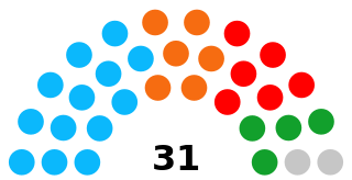
Mangalore Assembly constituency is one of the Karnataka Legislative Assemblies or Vidhan Sabha constituencies in Karnataka, India which belongs to Dakshina Kannada Lok Sabha constituency. Mangalore constituency along with Mangalore City South and Mangalore City North represents the Mangalore City.

