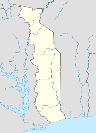
Togo, officially the Togolese Republic, is a country in West Africa. It is bordered by Ghana to the west, Benin to the east and Burkina Faso to the north. It extends south to the Gulf of Guinea, where its capital, Lomé, is located. It covers about 57,000 square kilometres with a population of approximately 8 million, and has a width of less than 115 km (71 mi) between Ghana and its eastern neighbor Benin.

Togo is a small Sub-Saharan state, comprising a long strip of land in West Africa. Togo's geographic coordinates are a latitude of 8° north and a longitude of 1°10′ east. It is bordered by three countries: Benin to the east, with 644 km (400 mi) of border; Burkina Faso to the north, with 126 km (78 mi) of border; and Ghana, with 877 km (545 mi) of border. To the south Togo has 56 km (35 mi) of coastline along the Bight of Benin of the Gulf of Guinea in the North Atlantic Ocean. Togo stretches 579 km (360 mi) north from the Gulf and is only 160 km (99 mi) wide at the broadest point. In total, Togo has an area of 56,785 km2 (21,925 sq mi), of which 54,385 km2 (20,998 sq mi) is land and 2,400 km2 (927 sq mi) is water.

Lomé is the capital and largest city of Togo. It has an urban population of 837,437 while there were 1,477,660 permanent residents in its metropolitan area as of the 2010 census. Located on the Gulf of Guinea at the southwest corner of the country, with its entire western border along the easternmost point of Ghana's Volta Region, Lomé is the country's administrative and industrial center, which includes an oil refinery. It is also the country's chief port, from where it exports coffee, cocoa, copra, and oil palm kernels.

Benin, a narrow, key-shaped, north–south strip of land in West Africa, lies between the Equator and the Tropic of Cancer. Its altitude ranges from 6°30′ N to 12°30′ N and its longitude from 1° E to 3°40′ E. It is bounded by Togo to the west, Burkina Faso and Niger to the north, Nigeria to the east, and the Bight of Benin to the south.

Beaver is a town in Carroll County, Arkansas, United States. As of the 2020 census it had a population of 67. The community is located on the White River at the western limits of Table Rock Lake deep in the Ozark Mountains. Located north of Eureka Springs, the small town has been featured in movies for its picturesque scenery. The town is known for the Beaver Bridge, a two-panel suspension bridge over the White River listed on the National Register of Historic Places.

Mineral is a census-designated place (CDP) in Tehama County, California, United States. The population was 123 at the 2010 census, down from 143 at the 2000 census.

Crosby is a census-designated place in Harris County, Texas, United States. The population was 3,417 at the 2020 census.

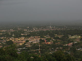
Sokodé is the second largest city in Togo and seat of the Tchaoudjo and Centrale Region in the center of the country, 339 kilometres (211 mi) north of Lomé. With a population of 86,500 (2004), currently at around 189,000, the city is situated between the Mo and Mono rivers, and it is a commercial center for the surrounding agricultural areas. It is a multi-ethnic and multi-religious city, but is dominated by Islam. It is an administrative center where the majority of Kotokolis live along with Muslims whose cloths are reminiscent of North Africa. Men have also been known to wear big boubous and women, the veil above beautifully colored outfits.
Ho is the capital city of the Ho Municipal District and the Volta Region of Ghana. The city lies between Mount Adaklu and Mount Galenukui or Togo Atakora Range, and is home to the Volta Regional Museum, a cathedral, and a prison. It was formerly the administrative capital of British Togoland now part of the Volta Region. The population of Ho Municipality according to the 2010 Population and Housing Census is 177,281 representing 8.4 percent of the region's total population. Females constitute 52.7 percent and males represent 47.3 percent. About 62 percent of the population resides in urban localities. The Municipality shares boundaries with Adaklu and Agotime-Ziope Districts to the South, Ho West District to the North and West and the Republic of Togo to the East. Its total land area is 2,361 square kilometers thus representing 11.5 percent of the region's total land area.

Atakpamé is the fifth largest city in Togo by population, located in the Plateaux Region of Togo. It is an industrial centre and lies on the main north-south highway, 161 km north of the capital Lomé. It is also a regional commercial centre for produce and cloth.

Savanes is the northernmost of the five Regions of Togo. Dapaong is the regional capital. Another major town in the region is Mango.

The Northern Region is one of the sixteen regions of Ghana. It is located in the north of the country and was the largest of the sixteen regions, covering an area of 70,384 square kilometres or 31 percent of Ghana's area until December 2018 when the Savannah Region and North East Region were created from it. The Northern Region is divided into 14 districts. The region's capital is Tamale.

Lodwar is the largest town in north-western Kenya, located west of Lake Turkana on the A1 road. Its main industries are basket weaving and tourism. The Loima Hills lie to its west. Lodwar is the capital of Turkana County. The town has a population of 82,970 in 2019.

Periyakulam is a major town and a municipality in Theni district, in the Madurai Region, South Indian state of Tamil Nadu. As of 2011, the town had a population of 42,976. Periyakulam is the northern gateway of the district.
The Championnat National de Premiere Division is a football league featuring clubs from Togo, and is the primary competition of Togolese football. Founded in 1961, it is administered by the Togolese Football Federation.
Tabligbo is a city and canton in Togo with 22,304 inhabitants (2010). It is the seat of Yoto prefecture in Maritime Region.

Oti is a prefecture located in the Savanes Region of Togo. The prefecture seat is located in Sansanné-Mango.
Akimsola Boussari is a Togolese football footballer who currently plays for Warri Wolves F.C.

The Oti Valley Faunal Reserve is a protected area in northeastern Togo, one of four Important Bird Areas (IBA) in the country. The site is mainly savanna and seasonally inundated floodplains on either side of the Oti River. It has a total area of 147,840 hectares and is located at 10°35'N and 0°40'E.