Maniitsoq Norite Belt

Last updated
Geological map of the Maniitsoq Norite Belt showing location of all samples from Waterton et al. (2020). Norite belt U-Pb zircon ages are shown adjacent to their sample locations. Ages are colour coded by whether the sample was classed as plagioclase-rich norite (red), pyroxene-rich melanorite (blue), or unclassified (grey). Approximate extent of the Maniitsoq Norite Belt is delineated by purple curves. S. B. = Supracrustal Belt. Location of map within Greenland shown in inset. Map of the Maniitsoq Norite Belt.pdf
Geological map of the Maniitsoq Norite Belt showing location of all samples from Waterton et al. (2020). Norite belt U-Pb zircon ages are shown adjacent to their sample locations. Ages are colour coded by whether the sample was classed as plagioclase-rich norite (red), pyroxene-rich melanorite (blue), or unclassified (grey). Approximate extent of the Maniitsoq Norite Belt is delineated by purple curves. S. B. = Supracrustal Belt. Location of map within Greenland shown in inset.

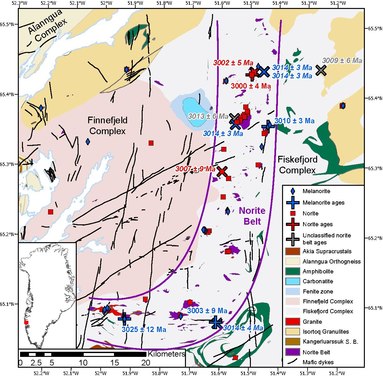
The Maniitsoq Norite Belt is a ~75 km x 15 km J-shaped belt of igneous norite intrusions, located in the Akia Terrane of the North Atlantic Craton, Greenland, near the town of Maniitsoq. [1] [2] [3] [4] The belt is found as enclaves ranging from meter-scale pods to 8 km2 large intrusive bodies within the ~3050 to 2990 Ma TTG and dioritic gneisses of the Akia terrane. [1] [4] and formed contemporaneously with the host gneisses between ~3013 and 3001 Ma [1] The norites underwent high grade granulite facies metamorphism at temperatures of ~800 °C and pressures of ~9 kbar (approximately 30 km depth) from ~3010 to 2980 Ma, soon after they were intruded. [1] [5] The norites were metamorphosed twice more at ~2.7 Ga and ~2.5 Ga. [6] [7]

A wide variety of norite types are found within the belt, which can be broadly divided into two main groups with different mineral proportions and chemical compositions; plagioclase-rich 'norites' and pyroxene-rich 'melanorites'. These are believed to have formed from fractional crystallisation of a single type of magma, with accumulation of dense minerals such as pyroxene in the melanorites, and accumulation of less-dense minerals such plagioclase in the norites. [1] Their geochemical compositions indicate that they crystallised from a mafic magma, derived from partial melting of a depleted mantle source, which subsequently assimilated large amounts of continental crust. The Maniitsoq Norite Belt was interpreted to have formed in an ultra-hot orogeny due to the combination of norite formation from depleted mantle melting and crustal assimilation, TTG formation due to melting in the crust, and high temperature metamorphism that immediately followed magmatism. [1]

The Maniitsoq Norite Belt has long been investigated for its nickel-copper-cobalt-platinum group element mineral potential. The belt was first explored by Kryolitselskabet Øresund A/S from 1959 to 1973, and subsequently investigated by Falconbridge Ltd., Nunaoil A/S, Cominco Ltd., NunaMinerals A/S, and most recently by North American Nickel Inc. [4] Exploration was ongoing as of 2019 and planned until 2021. [8] [9]

Related Research Articles

<span class="mw-page-title-main">Impact event</span> Collision of two astronomical objects

An impact event is a collision between astronomical objects causing measurable effects. Impact events have physical consequences and have been found to regularly occur in planetary systems, though the most frequent involve asteroids, comets or meteoroids and have minimal effect. When large objects impact terrestrial planets such as the Earth, there can be significant physical and biospheric consequences, though atmospheres mitigate many surface impacts through atmospheric entry. Impact craters and structures are dominant landforms on many of the Solar System's solid objects and present the strongest empirical evidence for their frequency and scale.

<span class="mw-page-title-main">Yilgarn Craton</span> Large craton in Western Australia

The Yilgarn Craton is a large craton that constitutes the bulk of the Western Australian land mass. It is bounded by a mixture of sedimentary basins and Proterozoic fold and thrust belts. Zircon grains in the Jack Hills, Narryer Terrane have been dated at ~4.27 Ga, with one detrital zircon dated as old as 4.4 Ga.

<span class="mw-page-title-main">Maniitsoq</span> Town in Greenland, Kingdom of Denmark

Maniitsoq, formerly Sukkertoppen, is a town in Maniitsoq Island, western Greenland located in the Qeqqata municipality. With 2,534 inhabitants as of 2020, it is the sixth-largest town in Greenland.

<span class="mw-page-title-main">Isua Greenstone Belt</span> Archean greenstone belt in southwestern Greenland

The Isua Greenstone Belt is an Archean greenstone belt in southwestern Greenland, aged between 3.7 and 3.8 billion years. The belt contains variably metamorphosed mafic volcanic and sedimentary rocks, and is the largest exposure of Eoarchaean supracrustal rocks on Earth. Due to its age and low metamorphic grade relative to many Eoarchaean rocks, the Isua Greenstone Belt has become a focus for investigations on the emergence of life and the style of tectonics that operated on the early Earth.

<span class="mw-page-title-main">Kaapvaal Craton</span> Archaean craton, possibly part of the Vaalbara supercontinent

The Kaapvaal Craton, along with the Pilbara Craton of Western Australia, are the only remaining areas of pristine 3.6–2.5 Ga crust on Earth. Similarities of rock records from both these cratons, especially of the overlying late Archean sequences, suggest that they were once part of the Vaalbara supercontinent.

<span class="mw-page-title-main">Barberton Greenstone Belt</span> Ancient granite-greenstone terrane in South Africa

The Barberton Greenstone Belt is situated on the eastern edge of the Kaapvaal Craton in South Africa. It is known for its gold mineralisation and for its komatiites, an unusual type of ultramafic volcanic rock named after the Komati River that flows through the belt. Some of the oldest exposed rocks on Earth are located in the Barberton Greenstone Belt of the Eswatini–Barberton areas and these contain some of the oldest traces of life on Earth, second only to the Isua Greenstone Belt of Western Greenland. The Makhonjwa Mountains make up 40% of the Baberton belt. It is named after the town Barberton, Mpumalanga.

<span class="mw-page-title-main">Tectonic evolution of the Barberton greenstone belt</span> Evolutionary history of ancient continental crust remnant located in southeastern Africa

The Barberton greenstone belt (BGB) is located in the Kapvaal craton of southeastern Africa. It characterizes one of the most well-preserved and oldest pieces of continental crust today by containing rocks in the Barberton Granite Greenstone Terrain (3.55–3.22 Ga). The BGB is a small, cusp-shaped succession of volcanic and sedimentary rocks, surrounded on all sides by granitoid plutons which range in age from >3547 to <3225 Ma. It is commonly known as the type locality of the ultramafic, extrusive volcanic rock, the komatiite. Greenstone belts are geologic regions generally composed of mafic to ultramafic volcanic sequences that have undergone metamorphism. These belts are associated with sedimentary rocks that occur within Archean and Proterozoic cratons between granitic bodies. Their name is derived from the green hue that comes from the metamorphic minerals associated with the mafic rocks. These regions are theorized to have formed at ancient oceanic spreading centers and island arcs. In simple terms, greenstone belts are described as metamorphosed volcanic belts. Being one of the few most well-preserved Archean portions of the crust, with Archean felsic volcanic rocks, the BGB is well studied. It provides present geologic evidence of Earth during the Archean (pre-3.0 Ga). Despite the BGB being a well studied area, its tectonic evolution has been the cause of much debate.

<span class="mw-page-title-main">Eastern Pilbara Craton</span> Carton in Western Australia

The Eastern Pilbara Craton is the eastern portion of the Pilbara Craton located in Western Australia. This region contains variably metamorphosed mafic and ultramafic greenstone belt rocks, intrusive granitic dome structures, and volcanic sedimentary rocks. These greenstone belts worldwide are thought to be the remnants of ancient volcanic belts, and are subject to much debate in today's scientific community. Areas such as Isua and Barberton which have similar lithologies and ages as Pilbara have been argued to be subduction accretion arcs, while others suggest that they are the result of vertical tectonics. This debate is crucial to investigating when/how plate tectonics began on Earth. The Pilbara Craton along with the Kaapvaal Craton are the only remaining areas of the Earth with pristine 3.6–2.5 Ga crust. The extremely old and rare nature of this crustal region makes it a valuable resource in the understanding of the evolution of the Archean Earth.

<span class="mw-page-title-main">Sveconorwegian orogeny</span> Orogenic belt in southwestern Sweden and southern Norway

The Sveconorwegian orogeny was an orogenic system active 1140 to 960 million years ago and currently exposed as the Sveconorwegian orogenic belt in southwestern Sweden and southern Norway. In Norway the orogenic belt is exposed southeast of the front of the Caledonian nappe system and in nappe windows. The Sveconorwegian orogen is commonly grouped within the Grenvillian Mesoproterozoic orogens. Contrary to many other known orogenic belts the Sveconorwegian orogens eastern border does not have any known suture zone with ophiolites.

The Maniitsoq structure was a proposed 3 billion-year-old impact structure located in the Akia terrane of the North Atlantic Craton, centred about 55 km (34 mi) south-east of the town of Maniitsoq, Greenland, at 65°15′N51°50′W. However, the Maniitsoq structure has not been widely recognised as an impact structure, and the proposal was criticised for not meeting established criteria for recognising impact craters. Furthermore, subsequent studies in the region have demonstrated that there is no evidence for an impact structure, and in fact a number of observations directly contradict the earlier impact structure proposals. The Maniitsoq structure is not recognised as an impact structure by the Earth Impact Database.

<span class="mw-page-title-main">Uruguayan dyke swarms</span>

The Uruguayan dyke swarms consist of three groups of dykes of Precambrian age that intrude Río de la Plata Craton and Brasiliano Cycle continental crust in Uruguay. The dykes – including the Florida dyke swarm, the Nico Perez dyke swarm, and the Treinta y Tres dyke swarm – are of mafic to intermediate composition and each group lies in a separate tectono-stratigraphic terrane. The rocks of the Florida dyke swarm have been quarried since the 1960s and are used in the construction industry as black dimension stone of very high quality, being marketed as "black granite".

<span class="mw-page-title-main">Huangling Anticline</span>

The Huangling Anticline or Complex represents a group of rock units that appear in the middle of the Yangtze Block in South China, distributed across Yixingshan, Zigui, Huangling, and Yichang counties. The group of rock involves nonconformity that sedimentary rocks overlie the metamorphic basement. It is a 73-km long, asymmetrical dome-shaped anticline with axial plane orientating in the north-south direction. It has a steeper west flank and a gentler east flank. Basically, there are three tectonic units from the anticline core to the rim, including Archean to Paleoproterozoic metamorphic basement, Neoproterozoic to Jurassic sedimentary rocks, and Cretaceous fluvial deposit sedimentary cover. The northern part of the core is mainly tonalite-trondhjemite-gneiss (TTG) and Cretaceous sedimentary rock called the Archean Kongling Complex. The middle of the core is mainly the Neoproterozoic granitoid. The southern part of the core is the Neoproterozoic potassium granite. Two basins are situated on the western and eastern flanks of the core, respectively, including the Zigui basin and Dangyang basin. Both basins are synforms while Zigui basin has a larger extent of folding. Yuanan Graben and Jingmen Graben are found within the Dangyang Basin area. The Huangling Anticline is an important area that helps unravel the tectonic history of the South China Craton because it has well-exposed layers of rock units from Archean basement rock to Cretaceous sedimentary rock cover due to the erosion of the anticline.

<span class="mw-page-title-main">Eoarchean geology</span> Study of the oldest crustal fragments on Earth

Eoarchean geology is the study of the oldest preserved crustal fragments of Earth during the Eoarchean era from 4.031 to 3.6 billion years ago. Major well-preserved rock units dated Eoarchean are known from three localities, the Isua Greenstone Belt in Southwest Greenland, the Acasta Gneiss in the Slave Craton in Canada, and the Nuvvuagittuq Greenstone Belt in the eastern coast of Hudson Bay in Quebec. From the dating of rocks in these three regions scientists suggest that plate tectonics could go back as early as Eoarchean.

<span class="mw-page-title-main">Tonalite–trondhjemite–granodiorite</span> Intrusive rocks with typical granitic composition

Tonalite–trondhjemite–granodiorite (TTG) rocks are intrusive rocks with typical granitic composition but containing only a small portion of potassium feldspar. Tonalite, trondhjemite, and granodiorite often occur together in geological records, indicating similar petrogenetic processes. Post Archean TTG rocks are present in arc-related batholiths, as well as in ophiolites, while Archean TTG rocks are major components of Archean cratons.

<span class="mw-page-title-main">Archean felsic volcanic rocks</span> Felsic volcanic rocks formed in the Archean Eon

Archean felsic volcanic rocks are felsic volcanic rocks that were formed in the Archean Eon. The term "felsic" means that the rocks have silica content of 62–78%. Given that the Earth formed at ~4.5 billion year ago, Archean felsic volcanic rocks provide clues on the Earth's first volcanic activities on the Earth's surface started 500 million years after the Earth's formation.

<span class="mw-page-title-main">Eastern Block of the North China Craton</span>

The Eastern Block of the North China Craton is one of the Earth's oldest pieces of continent. It is separated from the Western Block by the Trans-North China Orogen. It is situated in northeastern China and North Korea. The Block contains rock exposures older than 2.5 billion years. It serves as an ideal place to study how the crust was formed in the past and the related tectonic settings.

<span class="mw-page-title-main">Western Block of the North China Craton</span>

The Western Block of the North China Craton is an ancient micro-continental block mainly composed of Neoarchean and Paleoproterozoic rock basement, with some parts overlain by Cambrian to Cenozoic volcanic and sedimentary rocks. It is one of two sub-blocks within the North China Craton, located in east-central China. The boundaries of the Western Block are slightly different among distinct models, but the shapes and areas are similar. There is a broad consensus that the Western Block covers a large part of the east-central China.

The Akia terrane is a tectonostratigraphic terrane located in the North Atlantic Craton in southern West Greenland. The Akia terrane is bounded to the Southeast by the Eo- to Neo-archaean tectonostratigraphic terranes of the Nuuk region, and to the North by the recently recognised Alanngua Complex, which separates the Akia terrane from the Neoarchaean Tuno terrane. The crust in the Akia terrane formed in two major pulses. The first at ~3.2 Ga, predominantly comprises dioritic gneisses, whereas the second, at ~3.0 Ga comprises a more diverse mix of TTG and dioritic gneisses with enclaves of supracrustal rocks and mafic-ultramafic intrusions. Supracrustal rocks are largely tholeiitic and calc-alkaline amphibolites formed at ~3.07 Ga. The mafic-ultramafic intrusions include peridotite cumulates and a belt of noritic intrusions formed at the same time as the TTG gneisses, the Maniitsoq Norite Belt. Various tectonic settings have been proposed for the 3.0 Ga crust forming event, including subduction related magmatism, stagnant lid tectonic processes, and crust and mantle melting in an ultra-hot orogeny.

<span class="mw-page-title-main">Dharwar Craton</span> Part of the Indian Shield in south India

The Dharwar Craton is an Archean continental crust craton formed between 3.6-2.5 billion years ago (Ga), which is located in southern India and considered as the oldest part of the Indian peninsula.

<span class="mw-page-title-main">Geology of the Kimberley (Western Australia)</span> Overview of geology of the Kimberley

The geology of the Kimberley, a region of Western Australia, is a rock record of the early Proterozoic eon that includes tectonic plate collision, mountain-building (orogeny) and the joining (suturing) of the Kimberley and Northern Australia cratons, followed by sedimentary basin formation.

References

  1. 1 2 3 4 5 6 7 Waterton, Pedro; Hyde, William R.; Tusch, Jonas; Hollis, Julie A.; Kirkland, Christopher L.; Kinney, Carson; Yakymchuk, Chris; Gardiner, Nicholas J.; Zakharov, David; Olierook, Hugo K. H.; Lightfoot, Peter C. (2020-09-22). "Geodynamic Implications of Synchronous Norite and TTG Formation in the 3 Ga Maniitsoq Norite Belt, West Greenland". Frontiers in Earth Science. 8: 562062. Bibcode:2020FrEaS...8..406W. doi: 10.3389/feart.2020.562062 . hdl: 10023/20744 . ISSN   2296-6463.
  2. Secher (1983). "Noritic rocks and associated nickel-copper-sulphide occurrences in Sukkertoppen district, central West Greenland". The Geological Survey of Greenland Reports. 115: 30–34 via GEUS.
  3. Secher (2001). "The Pd + Pt dispersion in noritic and undifferentiated mafic rocks of the Archaean craton east of Maniitsoq, southern West Greenland". Danmarks og Grønlands Geologiske Undersøgelse Rapport. 123: 1–22 via GEUS.
  4. 1 2 3 Ravenelle, J. F., Weiershauser, L., and Cole, G. (2017). Report No.: 3CN024.004. Updated Independent Technical Report for the Maniitsoq Nickel-Copper-Cobalt-PGM Project, Greenland. Available at: https://s1.q4cdn.com/725069486/files/doc_downloads/technical_reports/Technical_Report_2017.pdf
  5. Yakymchuk, C.; Kirkland, C.L.; Hollis, J.A.; Kendrick, J.; Gardiner, N.J.; Szilas, K. (2020). "Mesoarchean partial melting of mafic crust and tonalite production during high-T–low-P stagnant tectonism, Akia Terrane, West Greenland". Precambrian Research. 339: 105615. Bibcode:2020PreR..339j5615Y. doi: 10.1016/j.precamres.2020.105615 . hdl: 10023/19439 .
  6. A. Steenfelt, J. Hollis, C. L. Kirkland, A. Sandrin, N. J. Gardiner, H. K. H. Olierook, K. Szilas, P. Waterton, C. Yakymchuk (2020-10-15). "The Mesoarchaean Akia terrane, West Greenland, revisited: New insights based on spatial integration of geophysics, field observation, geochemistry and geochronology". Precambrian Research. 352: 105958. doi: 10.1016/j.precamres.2020.105958 . hdl: 10023/21175 . ISSN   0301-9268.{{cite journal}}: CS1 maint: multiple names: authors list (link)
  7. Kirkland, C.L.; Yakymchuk, C.; Hollis, J.; Heide-Jørgensen, H.; Danišík, M. (2018-09-01). "Mesoarchean exhumation of the Akia terrane and a common Neoarchean tectonothermal history for West Greenland". Precambrian Research. 314: 129–144. Bibcode:2018PreR..314..129K. doi: 10.1016/j.precamres.2018.06.004 . ISSN   0301-9268.
  8. "Greenland Norite Belt Continues to Deliver with New Nickel Sulphide Discovery: 7.5m @ 1.26% Ni, 0.24% Cu and 0.47 g/t Pt+Pd+Au". www.northamericannickel.com. Retrieved 2020-11-06.
  9. "North American Nickel Reports Update on Maniitsoq Project". www.northamericannickel.com. Retrieved 2020-11-06.