
TIDEL Park is an information technology (IT) park situated in the city of Chennai, India. The name TIDEL is a portmanteau of TIDCO and ELCOT. An ISO 9001/14001 company, In 2000, it was one of the largest IT parks in India. It was set up in 2000 to foster the growth of information technology in the state of Tamil Nadu by the TIDEL Park Ltd, a joint venture of TIDCO and ELCOT.

Thiruvallikeni known as Triplicane, is one of the oldest neighbourhoods of Chennai, India. It is situated on the Bay of Bengal coast and about 0.6 km (0.37 mi) from Fort St George. The average elevation of the neighbourhood is 14 metres above sea level.

Saidapet, also known as Saidai, is a neighbourhood in Chennai, India, situated in the northern banks of the Adyar River and serves as an entry point to Central Chennai. It is surrounded by West Mambalam in the North, C.I.T Nagar in the North-East, Nandanam in the East, Guindy in the South, Jafferkhanpet and Ashok Nagar in the North-West. The Saidapet Court, the only other court of judicature in Chennai city apart from the Madras High Court, and the Saidapet bus depot are located here. Prior to its incorporation in Madras city, Saidapet functioned as the administrative headquarters of Chingleput district. The neighbourhood is served by Saidapet railway station of the Chennai Suburban Railway Network.
Tiruvottriyur is a neighbourhood in North Chennai, administered by the Greater Chennai Corporation. It is part of the Tondiarpet division, located to the north of Chennai. It is one of the fifteen administrative zones in the Greater Chennai Corporation. The zone is called Zone 1 (Tiruvottriyur).
Villivakkam is a neighbourhood of Chennai, Tamil Nadu, India. It is served by the Villivakkam railway station on the Chennai Central–Arakkonam suburban section. Villivakkam is the largest state assembly constituency in Tamil Nadu in terms of number of voters.

The Kālikāmbal Temple is a Hindu temple dedicated to Shri Kāligāmbāl (Kāmākshi) and Lord Kamadeswarar, located in Parry's corner locality of the city of Chennai, Tamil Nadu, India. The temple is located in Thambu Chetty Street, a prominent financial street at Georgetown, running parallel to Rajaji Salai.
Kilpauk is a semi residential area located in Chennai, Tamil Nadu, India. The distance from Chennai's city to Kilpauk is about 6 km. The region is situated off the Poonamallee High Road in the west. Adjacent areas of Kilpauk include Chetpet, Kellys, Egmore, Ayanavaram, Anna Nagar, Choolaimedu and Purasawalkam.

Broadway is one of the historical thoroughfares of the commercial centre of George Town in Chennai, India. The road runs north–south connecting China Bazaar Road in the south with Ibrahim Sahib Street in the north. The road divides George Town into Muthialpet and Peddanaickenpet.

Anna Salai, formerly known as St. Thomas Mount Road or simply Mount Road, is an arterial road in Chennai, India. It starts at the Cooum Creek, south of Fort St George, leading in a south-westerly direction towards St. Thomas Mount, and ends at the Kathipara Junction in Guindy. Beyond the Kathipara Junction, a branch road arises traversing westwards to Poonamallee to form the Mount-Poonamallee Road while the main branch continuing southwards to Chennai Airport, Tambaram and beyond to form Grand Southern Trunk Road. Anna Salai, which is more than 400 years old, is acknowledged as the most important road in Chennai city. The head offices of many commercial enterprises and public buildings are located along Anna Salai. It is the second longest road in Chennai, after EVR Periyar Salai.

George Town is a neighbourhood in Chennai, Tamil Nadu, India. It is near the Fort Saint George, Chennai. It is also known as Muthialpet and Parry's corner. It is an historical area of Chennai city from where its expansion began in the 1640s. It extends from the Bay of Bengal in the east to Park town on the west. The Fort St. George is on the south, to Royapuram in the north. The Fort St. George houses the Tamil Nadu Legislative Assembly and the Secretariat. The High court of Tamil Nadu at Chennai, Dr. Ambedkar Law College, Stanley Medical College and Hospital are located here.
Alwarthirunagar is an urban locality in Chennai, the capital city of Tamil Nadu, India. Alwarthirunagar Pin code is 600087 and postal head office is Valasaravakkam. It falls under Valasaravakkam municipality, in Maduravoyal constituency in Tiruvallur district in the Indian state of Tamil Nadu. The word nagar refers to a settlement in sanskrit. The neighbourhood was developed by the City Lando Corporation in the late 1960s. With the opening of schools and shopping centres, Alwarthirunagar emerged as a service centre in Chennai's west. Twenty acres of forestation in the area acts against pollution. The area is traversed by state road number 113.
Madhavaram Milk Colony is a neighbourhood in northern Chennai, a metropolitan city in Chennai district in the Indian state of Tamil Nadu.

Tiruchirappalli has a well-developed transport infrastructure. Being located almost at the geographic centre of the state Tamil Nadu India, Tiruchirappalli is well connected by Road, Rail and Air with most cities.

Rajaji Hall, previously known as the Banqueting Hall, Madras, is a public hall in the city of Chennai, India used for social functions. The hall was built by John Goldingham to commemorate the British victory over Tipu Sultan in the Fourth Anglo-Mysore War.
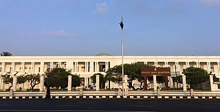
The Police headquarters building is a heritage building in Chennai, Tamil Nadu, India. It is located facing the Marina Beach opposite the Queen Mary's College and the lighthouse on the junction of Dr. Radhakrishnan Salai and Kamaraj Salai. It was built in 1839. It houses the director general (DGP) of the Tamil Nadu Police. The building was renovated in 1993.
Chennai, with historically rich records dating at least from the time of the Pallavas, houses 2,467 heritage buildings within its metropolitan area (CMA), the highest within any metropolitan area limit in India. Most of these buildings are around 200 years old and older. Chennai is home to the second largest collection of heritage buildings in the country, after Kolkata. The official list of heritage buildings was compiled by the Justice E. Padmanabhan committee. The Tamil Nadu Assembly passed the Heritage Commission Act in 2012 to preserve old heritage structures.

Peravallur is a developed residential area, located on the north - western corner of Madras, a metropolitan city in Tamil Nadu state, India. Out of 1018 places to be renamed by the government of Tamil Nadu, Peravallur is the one to be renamed as "Peravalloor". CMDA is the town planning agency for Peravallur. Official language is Tamil; Postal pincode is 600082; Greater Chennai Corporation is the Civic body. A police station viz., K - 5 Peravallur Police Station for this neighborhood is built a year ago with ample space, at the junction of Venkatesan Salai and Siva Elango Salai in Jawahar Nagar near Perambur.

Royapettah is a neighbourhood of Chennai, India.
