Mannathara

Last updated

Mannathara
village
CountryFlag of India.svg  India
State Kerala
District Idukki
Languages
  Official Malayalam, English
Time zone UTC+5:30 (IST)
PIN
685515
Telephone code04868
Vehicle registration KL-
Nearest cityCochin a
Literacy100%%
Lok Sabha constituencyIdukki

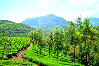
Mannathara is a village in the Idukki District of Kerala on the southwest coast of India, located in the high ranges of the Western Ghats (Sahyadri). Mannathara is part of the Vathikudy Gramapanchayath and Idukki Talku. The word mannathra evolves from the name of a tribal group called Mannan. Mannans were the early inhabitants of in the region. It is believed that Mannans migrated from the dry plains of Tamil Nadu in search of livelihood in the hills. They were engaged in mainly hill cultivation of ragi, millet and rice as well as gathering cardamom, hill pepper, honey and other medicinal plants for exchange from the early period. The word Mannathra refers to a burial ground of the Mannan. The village had evidence of megalithic settlement sites. However, the majority of the material pieces of evidence to learn more about the prehistoric and early historic periods are not surviving. However, the ecological settings of this micro-region call attention from paleo-archaeologists. The continuous human intervention started in the mid-twentieth century destroyed most of the historically rich sites.

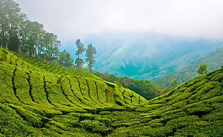
Up to the late nineteenth century, this area was part of the Western Ghats forest controlled by the Travancore State. With the expansion of the Travancore state power to the hills, state sub-contractors engaged in the collection of forest resources such as honey, cardamom and waxes for the commercial agents of Travancore Government and traders from Tamil plains and Kerala. The tribal groups were incorporated into this process of extraction of forest resources. Later, Cardamom cultivation as a commercial enterprise flourished in the early decades of the twentieth century with the expansion of the market for spices. The place called near Mannathara Kanam refers back to the Elakananm (cardamom plantation) existed in the pre-1980s period. Migration of the peasants in the 1950s and 1960s was the major turning point in the history of this forest hilly region into an agrarian village. The economic depression of the 1930s, the Second World War, and a remarkable increase in the population in the agrarian mid-land forced low holding peasants to clear forest land to cultivate food crops and cash crops. The migrant peasants practised both dryland cultivation of rice, cassava (tapioca), Lemon Grass oil, cardamom, ginger, pepper, and other spices. Landless and smallholding farmers from the erstwhile princely state regions; mainly from Palai, Ettumanoor, Kothamangalam, Thodupuzha, and Melukavu migrated to western Ghats. This was largely connected with the larger project to accelerate the production of 'cash crops'. In the later decades, the entire high range, as Father Vadakkan mentioned in his biography Ente Kuthippum Kitaappum became the backbone of the Kerala Economy.

This village is famous for its high quality black pepper. Black pepper and cardamon from this area had been considered as special quality in the Mattancherry spice market in Cochin. But the leaf disease of black pepper (Kurumulku valli) in the late 1980s onwards was a major backlash to the agrarian change of Mannathara. Moreover, the import of black pepper from other parts of the world to Cochin port and mixing of the imported goods with high-quality pepper from idukki affected the demand of high range pepper in the international market.

In the 1990s as elsewhere in India, Neo-liberal policies of the government affected Mannathara's agro-economy as well. The rollback of the Government of Indian and the State government from the welfare policies for peasants and elimination of subsidy for fertilizers increased the risk of investment. The risk of investment was high in the case of ginger, plantain, and areca nut cultivation. The heavy fluctuations in the climate and various crop diseases increased the burden of the peasants. Cultivation of cassava (tapioca) and rice and milk products were the ways to meet their ends. Milma (APCOS) corporation of the Kerala State Government was a helping hand to the peasants. Nursing as a profession with employment chances attracted the lower-middle-class peasant families. The agrarian crisis of compelled young women to prefer nursing as a profession to support the family. Trained nurses, mostly from Syrian Christian and ezhava families migrated to middle eastern countries, Delhi, Bangalore, Chennai. Now there are a few families has its members in America and England. Daughters of Chennamkulam Pappachan and the son of Paulose Eenthumkal are in the USA. Although most of the lower-middle-class family remain unchanged in their economic condition, some of the families enjoy economic mobility.


Geography

Until the beginning of the 21st century, a long strip of rice field was the landmark and the main attraction of Mannathara. The Swampy land between two hills formed wetland paddy field with a two-meter wide and one and a half meter deep stream called the Mannathara thodu. The Mannathra thodu flowing in the middle of the rice field is the lifeline of Mannathara, which eventually joined the Periyar river. Now the decline in rice production due to various reasons affected the Mannathara rice filed as well. Overflowing of this stream in the heavy monsoon months helps to balance the fertility of this rice field. But the first thing we would have noticed in the last century would have been the poor transport infrastructure of this region. The Government had been largely ignoring the transport development of the region for decades. It is only after 1995, a positive reaction is visible from the side of authorities. Now, Rajamudi-Thoprumkudy main state high way and Mannathara-Perumthotty road are the lifelines of the village. These two tarred roads connect Mannathra with other villages and market places including Kattappana, Murickassery, Cheruthony, and Nedumkandam and connects the region with a larger market place such as Thodupuzha, and Kothamangalam.

Education 'Holy Family Upper Primary School:' The school had its early beginning in the 1950s as an informal learning centre alongside the Holy Family Church. Later, a lower primary government school was established at Kiliyar and the upper primary section continued in the church. The school is popularly known as the Mannathara school. This school has produced a list of distinguished alumni from the neighbourhood of the school. This list of former students include Dr. Justin Mathew Olickal (Professor, Delhi University),Siby Mathew Vattappilil (Engineer Canada), Fr. Jimmy Kuzhikandathil (Christian Priest, Idukki), Fr. Binoy Chathanattu (Priest, Idukki), Dr. Sr. Swapna Mathew Olickal (Medical Doctor, Thiruvananthapuram), Fr. Shinto Mangalathu (Christian Priest), Binish Pathippalil (Manager, Federal Bank), Saji Chennamkulam (School Staff, Rajasthan), and many more.

Pilgrim Fathers Mathew Mathai Olickal (Pappachan) Mathai Mathai Olickal (Kunjunju), Zcharia Ulahannan Chennamkulam (pappachan), Mathai Ulahannan Cehnnamkulam, Varkkey Niravathu, Varkky Mukalayil, Varghese Enthumkal, Varky Mathai Oilckal, Zacharias Manthara, and many more

Major roads

Roads suitable for motor vehicle transport was developed from the 1980s onward. Most of the tarred roads are PWD or Panchayath maintained. All these roads were initially one-foot tracks developed by the community cooperation of the local people, mostly farmers.

List of Roads Passing through Mannathara: Cheruthoni- Rajamudi-Thopramkudy highway- pass through Mannathara junction

Mannathara Junction- Church-Manthikkvala- Perumthotty- Road- This is one of the main roads passing through the village.

Manthikkavala-Mantharappadi-Kiliyar Road

Kambanippadi-Anganvadikkavala Road- This was a long-abandoned road after the 1970s. Recently, PT Thomas (Ex MP Idukki) included this road in the Pradan matri Grameen Sadak Yojana scheme (PMGSY) and completed the work in March 2017 and opened for traffic. Now this road has become a busy link between Murikkasserry-Rajamud- Padamugham regions to Kiliyar-Prakash-Chempakappara-Kattappana.

Mannathra Rajya Hall-Pathinezhu Kambani road

Panachinanippadi-Kiliyar Road

Related Research Articles

<span class="mw-page-title-main">Ernakulam district</span> District in Kerala, India

Ernakulam is one of the 14 districts in the Indian state of Kerala, and takes its name from the eponymous city division in Kochi. It is situated in the central part of the state, spans an area of about 2,924 square kilometres (1,129 sq mi), and is home to over 9% of Kerala's population. Its headquarters are located at Kakkanad. The district includes Kochi, also known as the commercial capital of Kerala, which is famous for its ancient Churches, Hindu temples, synagogues and mosques. The district includes the largest metropolitan region of the state: Greater Cochin. Ernakulam is the district that yields the most revenue and the largest number of industries in the state. Ernakulam is the third most populous district in Kerala, after Malappuram and Thiruvananthapuram. The district also hosts the highest number of international and domestic tourists in Kerala state.

<span class="mw-page-title-main">Munnar</span> Town in Kerala, India

Munnar is a town and hill station in the Idukki district of the southwestern Indian state of Kerala. Munnar is situated at around 1,600 metres (5,200 ft) above mean sea level, in the Western Ghats mountain range. Munnar is also called the "Kashmir of South India" and is a popular honeymoon destination.

<span class="mw-page-title-main">Thodupuzha</span> Municipal town in Kerala, India

Thodupuzha is a municipal town located in Idukki district, Kerala, India, that covers an area of 35.43 km2 (13.68 sq mi). It lies on the banks of Thodupuzha river, which merges with the Kaliyar and Kothamangalam rivers at Muvattupuzha to form the Muvattupuzha river. Thodupuzha is 53 km (33 mi) from Kottayam, 75 km (47 mi) from Kattappana and 60 km (37 mi) south east of Kochi. Thodupuzha is 197 km (122 mi) from the state capital, Trivandrum. The geographical classification of the Thodupuzha Region is Malanad or Keezhmalanad.

<span class="mw-page-title-main">Idukki district</span> District in Kerala, India

Idukki is one of the 14 districts in the Indian state of Kerala. It is the largest district in Kerala and lies amid the Cardamom Hills of Western Ghats in Kerala. Idukki district contains two municipal towns - Kattappana and Thodupuzha, and five taluks.

<span class="mw-page-title-main">Muvattupuzha</span> Municipality in Kerala, India

Muvattupuzha is a town, municipality in the midlands directly to the east of Kochi in Ernakulam district, Kerala, India. It is located about 36 km (22 mi) from downtown Kochi, and is a growing urban centre in central Kerala. The town is also the starting point of the Muvattupuzhayar, which is a confluence formed by three rivers: the Thodupuzhayar, Kaliyar, and Kothayar.

<span class="mw-page-title-main">Cardamom Hills</span> Mountain range in Kerala, India

The Cardamom Hills or Yela Mala are mountain range of southern India and part of the southern Western Ghats located in Idukki district, Kerala, India. Their name comes from the cardamom spice grown in much of the hills' cool elevation, which also supports pepper and coffee. The Western Ghats and Periyar Sub-Cluster including the Cardamom Hills are UNESCO World Heritage Sites.

<span class="mw-page-title-main">Peermade</span> Hill station in Kerala, India

Peermade, also spelt Peerumedu is a village, Grama Panchayat and hill station in the state of Kerala, India. It lies 915 metres (3,002 ft) above sea level in the Western Ghats (Sahyadri) about 85 kilometres (53 mi) east of Kottayam on the way to Thekkady through the nearby city of Kanjirappally.

Melechinnar is a small village in Idukki district of Kerala, India and is situated on the banks of a small river named Chinnar. Most of the inhabitants make their living from agriculture.

<span class="mw-page-title-main">Kumily</span> Plantation Town in Kerala, India

Kumily, also spelt as Kumaly is a revenue village and Gram Panchayat in the Idukki district of Kerala. It is a town in Cardamom Hills near Thekkady and Periyar Tiger Reserve. Kumily is a gateway town into Kerala from Tamil Nadu.

<span class="mw-page-title-main">Kattappana</span> Municipality in Kerala, India

Kattappana is a municipal town in the Sahyadri of Kerala state, India. It is the main urban centre in the high ranges of Idukki district, situated about 2,788.71–2,952.76 feet (850.00–900.00 m) from sea level. It is the second city to become a municipality in Idukki District. It is a major commercial town and flourished with the boost in production of agriculture and spices.

Nedumkandam is the headquarters of Udumbanchola taluk which is situated in Idukki district of the Indian state of Kerala. Nedumkandam is among the fastest growing towns in the Idukki district. Nedumkandam is well known for its spices production and is a major contributor to the production of spices like cardamom and pepper. This town situated an average elevation of 900 meter above sea level and maximum elevation respectively 1190 meter 1100 meter and 975 meter and is a destination for economical stay and shopping for tourists in the popular Kumily-Munnar tourist route.

<span class="mw-page-title-main">Ayyappancoil</span> Village in Kerala, India

Ayyappancoil, also spelt Ayyappankovil is a village in newly formed Idukki taluk in Idukki district in the Indian state of Kerala. The place is popular for having a suspension bridge with a length of 200 meters and an old historic Sastha temple on the banks of Periyar river.

Upputhara is a village in Idukki district in the Indian state of Kerala. Upputhara panchayat, belonging to the block panchayat of Kattappana, is situated in the southern part of Idukki district in the Peermade taluk. The panchayat is bordered by the Periyar River in the east, the Meenmutti Lake in the west, the Chinnar River and the Karintharuvi River in the south and the Kakkathode protected forests in the north. Upputhara is located in the Western Ghats region of Kerala that borders on the neighbouring State of Tamil Nadu. Geographically, Upputhara is divided into six types of land forms; mountains, highly steep land, moderately steep land, valleys, marshy lands and rocky lands. Of these six land forms, about 40 percent of the total area is classified under valleys. Next in importance are marshy lands, slightly steep land, mountains, very steep land and rocky lands, in that order. Valleys and marshy lands together accounted for 62 percent of the area. Owing to the presence of large tracts of land with undulating topography, agriculture in Upputhara is faced with several challenges such as soil erosion.

<span class="mw-page-title-main">Adimali</span> Town in Kerala, India

Adimali is a town in the Idukki district of Kerala, India. National Highway 185 is a highway in India running from Adimali to Kumily through Kattappana and ends in Adoor in Kerala. Adimaly is located on the National Highway 49, now NH 85, known as Kochi-Dhanushkodi National Highway, earlier known as the Kochi Madhura Highway (India) connecting Kochi and Madurai, India. From Adimaly, it is only 27 kilometers to Munnar, which is a famous hill station. The waterfalls Cheeyappara, Adimali waterfalls and Valara are located nearby. Pepper and cocoa cultivation is the main agricultural activity of this place. The Ponmudi Dam was constructed in 1963 across the Panniar river, nearly 15 km southeast of Adimali, on the way to Rajakkad.Thopramkudy is the nearest town. Adimali is known for its proximity to Munnar and natural environment. Adimali has almost all the basic facilities like roads, super markets, markets, educational institutions and hospitals.

<span class="mw-page-title-main">Kanchiyar</span> Village in Kerala, India

Kanchiyar is a village located in Idukki taluk of Idukki district, Kerala, India. The place has a vast cardamon and pepper plantations. Anchuruli, one of the famous tourist spots in Idukki district is located in Kanchiyar panchayath. The main settlements in Kanchiyar are Kozhimala, Swaraj, Labbakkada, Thoppipala, Mattappally and Kakkattukada.

Pandippara is a small village in Idukki District in Kerala, India.

<span class="mw-page-title-main">Anakkara (Idukki)</span> Village in Kerala, India

Anakkara is a geographic area of around 50 square kilometres that spans across Vandanmedu, Chakkupallam Panchayats in the Udumbanchola Taluk of Idukki District. Anakkara is the administrative capital of Chakkupallam Grama Panchayat and Anakkara Revenue Village. Situated at about 18 kilometers (11 mi) from Thekkady wildlife sanctuary on the Kumily-Munnar state highway, Anakkara is a fast-growing tourist destination for its unique spice gardens and many picnic spots in and around. It is one of the 36 distinct places identified by Government of India and United Nations Development Programme for exploring and promoting the unique tourism potential of these places.

<span class="mw-page-title-main">Muttom, Thodupuzha</span> Gram Panchayat in Kerala, India

Muttom is a rural area in Idukki district in the Indian state of Kerala. This place is 66 km away from Cochin. Geographically this place is part of Midland or Idanad region of Kerala.

<span class="mw-page-title-main">Rajamudy</span> Village in Kerala, India

Rajamudy is a small village in Idukki district of Kerala state, India. It is in the "High Ranges" which lie in the lap of Western Ghats. .

The High Ranges of Kerala is a hilly tract located across the Kerala state of southern India and is treated as a part of the Western Ghats.

References