Glastonbury Abbey was a monastery in Glastonbury, Somerset, England. Its ruins, a grade I listed building and scheduled ancient monument, are open as a visitor attraction.

Meare is a village and civil parish 3 miles (4.8 km) north west of Glastonbury on the Somerset Levels, in the Mendip district of Somerset, England. The parish includes the village of Westhay.

West Pennard is a village and civil parish east of Glastonbury, situated at the foot of Pennard Hill, in the Mendip district of Somerset, England. The parish includes the hamlets of Coxbridge and Woodlands.

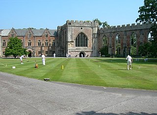
The Bishop's Palace and accompanying Bishops House at Wells in the English county of Somerset, is adjacent to Wells Cathedral and has been the home of the Bishops of the Diocese of Bath and Wells for 800 years. It has been designated by English Heritage as a Grade I listed building.

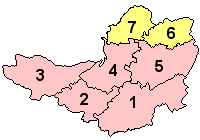
The Grade I listed buildings in Somerset, England, demonstrate the history and diversity of its architecture. The ceremonial county of Somerset consists of a non-metropolitan county, administered by Somerset County Council, which is divided into five districts, and two unitary authorities. The districts of Somerset are West Somerset, South Somerset, Taunton Deane, Mendip and Sedgemoor. The two administratively independent unitary authorities, which were established on 1 April 1996 following the breakup of the county of Avon, are North Somerset and Bath and North East Somerset. These unitary authorities include areas that were once part of Somerset before the creation of Avon in 1974.
Meare Pool was a lake in the Somerset Levels in South West England. Lake villages existed there in prehistoric times. During medieval times it was an important fishery, but following extensive drainage works it had disappeared from maps in the eighteenth century.
Mendip is a local government district in the English county of Somerset. The Mendip district covers a largely rural area of 285 square miles (738 km2) ranging from the Mendip Hills through on to the Somerset Levels. It has a population of approximately 11,000. The administrative centre of the district is Shepton Mallet.
The medieval Glastonbury canal was built in about the middle of the 10th century to link the River Brue at Northover with Glastonbury Abbey, a distance of about 1.75 kilometres (1,900 yd). Its initial purpose is believed to be the transport of building stone for the abbey, but later it was used for delivering produce, including grain, wine and fish, from the abbey's outlying properties. It remained in use until at least the 14th century, but possibly as late as the mid-16th century. English Heritage assess the canal remains, based on a "provisional" interpretation, as a site of "national importance".

The Abbot's Fish House in Meare, Somerset, England, was built in the 14th century and has been designated as a Grade I listed building and Scheduled Ancient Monument. It is the only surviving monastic fishery building in England.

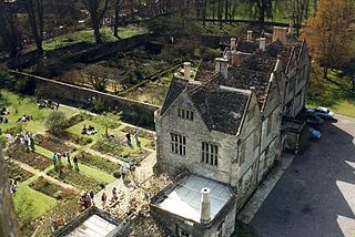
Mells Manor at Mells, Somerset, England, was built in the 16th century for Edward Horner, altered in the 17th century, partially demolished around 1780, and restored by Sir Edwin Lutyens in the 20th century. The house, along with the garden walls, has been designated as a Grade I listed building, and is closely associated with the adjacent Church of St Andrew. The gardens are listed, Grade I, on the Register of Historic Parks and Gardens of special historic interest in England.

Montacute Priory was a Cluniac priory of the Benedictine order in Montacute, Somerset, England.

Mendip is a local government district in the English county of Somerset. The Mendip district covers a largely rural area of 285 square miles (738 km2) ranging from the Mendip Hills through on to the Somerset Levels. It had a population of approximately 110,000 in 2014. The administrative centre of the district is Shepton Mallet.

North Somerset is a unitary authority in the ceremonial county of Somerset, England. As a unitary authority, North Somerset is administered independently of the non-metropolitan county of Somerset. Its administrative headquarters are located in the town hall of Weston-super-Mare.

Mendip is a local government district of Somerset in England. The Mendip district covers a largely rural area of 285 square miles (738 km2) ranging from the Mendip Hills through on to the Somerset Levels. It has a population of approximately 110,000. The administrative centre of the district is Shepton Mallet but the largest town is Frome.

There are over 670 scheduled monuments in the ceremonial county of Somerset in South West England. The county consists of a non-metropolitan county, administered by Somerset County Council, which is divided into five districts, and two unitary authorities. The districts of Somerset are West Somerset, South Somerset, Taunton Deane, Mendip and Sedgemoor. The two administratively independent unitary authorities, which were established on 1 April 1996 following the breakup of the county of Avon, are North Somerset and Bath and North East Somerset. These unitary authorities include areas that were once part of Somerset before the creation of Avon in 1974.

The Anglican Church of St Benedict at Glastonbury within the English county of Somerset was built in the 14th century with the tower being added in the 15th. It is a Grade I listed building.

Shapwick Manor at Shapwick in the English county of Somerset is a medieval manor house which was largely remodelled in the 19th century by Henry Strangways on his return from South Australia in 1871. It is a Grade II* listed building.


