
The Wellesley Islands are a group of islands off the coast of north Queensland, Australia, in the Gulf of Carpentaria. They are a locality within the Shire of Mornington local government area. In the 2016 census, Wellesley Islands had a population of 1,136 people.

The Seal Islands are a group of small islands and rocky islets lying about 7 km north and north-west of Elephant Island, in the South Shetland Islands of Antarctica. They extend east–west for about 5 km, and are separated from Elephant Island by Sealers Passage. The group takes its name from the largest island, which Captain William Smith named Seal Island in 1820 because of the number of seals killed there.

Shirley Island is a rocky island lying 200 m (220 yd) north-west of the western end of the Bailey Peninsula, in the Windmill Islands of the Budd Coast, Wilkes Land, Antarctica. It is mostly ice-free with undulating, rocky terrain. It was first mapped from aerial photos taken by the USN's Operation Highjump in February 1947. It was named by the US-ACAN for Q. Shirley, chief photographer's mate on Operation Highjump photographic flights in coastal areas between 14° and 164° E longitude. Kirkby Shoal is a small shoal area with depths of less than 18 meters (59 ft) extending about 140 meters (459 ft) westwards and south-south-west, about 3.4 km (2.1 mi) from the summit of Shirley Island. Launch Channel is the narrow body of water between Bailey Peninsula and the island; with the relatively shallow soundings in the channel restricting its use to smaller craft and suggesting the name.

The Shanks Islands form a group of five small rocky islets located close to the south-western coast of Tasmania, Australia. Situated near where the mouth of Port Davey meets the Southern Ocean, the islets have a combined area of 2.72 hectares and are part of the Swainson Islands Group. They comprise part of the Southwest National Park and the Tasmanian Wilderness World Heritage Site.

Night Island is a small granite island, with an area of 2.59 ha, is part of the Preservation Island Group, lying in eastern Bass Strait south of Cape Barren Island in the Furneaux Group, Tasmania, Australia.

O'Brien Island is a small rocky island in the South Shetland Islands of Antarctica. It lies 4 kilometres (2 nmi) south-west of Aspland Island and rises to 540 m. The name dates back to the survey of the South Shetlands carried out by Edward Bransfield and William Smith in 1820, when it was applied to O'Brien, Eadie and Aspland Islands as a group. It is now established in international usage.

The Tasman Island, part of the Tasman Island Group, is an oval island with an area of 1.2 square kilometres (0.46 sq mi), lying close to the south-eastern coast of Tasmania, Australia. The island is located in the Tasman Sea, situated off the Tasman Peninsula and is contained within the Tasman National Park.

The Wild Wind Islets comprise a group of five steep rocky unpopulated islets located close to the south-western coast of Tasmania, Australia. Situated some 2 kilometres (1.2 mi) south of where the mouth of Port Davey meets the Southern Ocean, the 3.95-hectare (9.8-acre) islets are one of the eight islands that comprise the Mutton Bird Islands Group. The Wild Wind Islets are part of the Southwest National Park and the Tasmanian Wilderness World Heritage Site.
The East Pyramids comprise a group of three steep, rocky unpopulated islets located close to the south-western coast of Tasmania, Australia. Situated some 2 kilometres (1.2 mi) south of where the mouth of Port Davey meets the Southern Ocean, the 6.69-hectare (16.5-acre) islets are one of the eight islands that comprise the Mutton Bird Islands Group. The East Pyramids are part of the Southwest National Park and the Tasmanian Wilderness World Heritage Site.
The Sugarloaf Rock is a steep, rocky unpopulated islet located close to the south-western coast of Tasmania, Australia. Situated some 2 kilometres (1.2 mi) south of where the mouth of Port Davey meets the Southern Ocean, the 3.56-hectare (8.8-acre) islet is one of the eight islands that comprise the Mutton Bird Islands Group. The Sugarloaf Rock is part of the Southwest National Park and the Tasmanian Wilderness World Heritage Site.
The Mavourneen Rocks is a group of four steep, rocky islets that lie within Port Davey, an oceanic inlet, located in the south west region of Tasmania, Australia. The islets have a combined area of approximately 0.88 hectares and are contained with the Southwest National Park, part of the Tasmanian Wilderness World Heritage Site and the Port Davey/Bathurst Harbour Marine Nature Reserve.

The Mackellar Islands, also MacKellar Islets, are a group of about 30 small islands and rocks lying 3 kilometres (1.5 nmi) north of Cape Denison in the center of Commonwealth Bay, George V Land, Antarctica. They were discovered by the Australasian Antarctic Expedition (1911–14) under Douglas Mawson, who named them for C.D. Mackellar of London, a patron of the expedition. The largest is Greater Mackellar Island.

Higginson Island is a small island in the Arafura Sea lying off the north-eastern coast of Arnhem Land, in the Northern Territory of Australia. It is one of the East Bremer Islets, lying to the north and east of the much larger Bremer Island.

The Port Davey Islands Important Bird Area comprises over 20 small, rocky islands scattered both within, and in the vicinity of, the mouth of Port Davey, an inlet on the south-west coast of Tasmania, Australia. They all lie within the Southwest National Park and are important for breeding seabirds.
Seagull Island is a 58 ha linear sand island, about 2.5 km long, lying 4 km off Cape Van Diemen on the north-west coast of Melville Island, in the Tiwi Island group, in the Northern Territory of Australia. It is an important breeding site for seabirds.

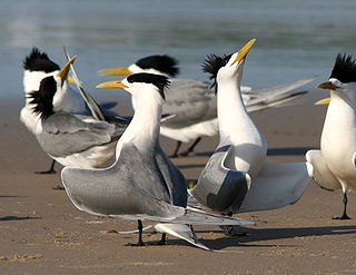
The South Barnard Islands Important Bird Area comprises a group of two small islands and a sand islet, with a combined area of 15 ha, on the inner Great Barrier Reef, Far North Queensland, Australia. The group lies about 6 km off the coast and 26 km south-east of Innisfail and is protected within the Barnard Island Group National Park. It is an important breeding site for terns.

St Helens Important Bird Area comprises four separate sites, with a collective total area of 24 km2, in the vicinity of the town of St Helens on the northern part of the east coast of Tasmania, south-eastern Australia.
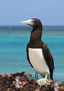
Stapleton Island is a small (4 ha) island on the northern Great Barrier Reef of Far North Queensland, Australia. It lies about 40 km off Cape Melville on the east coast of the Cape York Peninsula. It is important as a nesting site for boobies and terns.

The Three Hummocks Islands are a group of small granite islands, with a collective area of 190 ha, lying off the east coast of Arnhem Land’s Gove Peninsula in the north-western Gulf of Carpentaria, in the Northern Territory of Australia. They are important as a nesting site for terns.
The Three Sisters Island or Three Sisters Islands are three small and rocky granite islands, with a collective land area of 2 hectares, located in the Bass Strait, lying 500 metres (1,600 ft) off the north coast of Tasmania, Australia, between the towns of Penguin and Ulverstone.
