A web application is application software that runs on a web server, unlike computer-based software programs that are run locally on the operating system (OS) of the device. Web applications are accessed by the user through a web browser with an active network connection. These applications are programmed using a client–server modeled structure—the user ("client") is provided services through an off-site server that is hosted by a third-party. Examples of commonly-used web applications include: web-mail, online retail sales, online banking, and online auctions.
In computing, the Open Geospatial Consortium Web Feature Service (WFS) Interface Standard provides an interface allowing requests for geographical features across the web using platform-independent calls. One can think of geographical features as the "source code" behind a map, whereas the WMS interface or online tiled mapping portals like Google Maps return only an image, which end-users cannot edit or spatially analyze. The XML-based GML furnishes the default payload-encoding for transporting geographic features, but other formats like shapefiles can also serve for transport. In early 2006 the OGC members approved the OpenGIS GML Simple Features Profile. This profile is designed both to increase interoperability between WFS servers and to improve the ease of implementation of the WFS standard.
In computing, GeoServer is an open-source server written in Java that allows users to share, process and edit geospatial data. Designed for interoperability, it publishes data from any major spatial data source using open standards. GeoServer has evolved to become an easy method of connecting existing information to virtual globes such as Google Earth and NASA World Wind as well as to web-based maps such as OpenLayers, Leaflet, Google Maps and Bing Maps. GeoServer functions as the reference implementation of the Open Geospatial Consortium Web Feature Service standard, and also implements the Web Map Service, Web Coverage Service and Web Processing Service specifications.
In computing, a solution stack or software stack is a set of software subsystems or components needed to create a complete platform such that no additional software is needed to support applications. Applications are said to "run on" or "run on top of" the resulting platform.

Manifold System is a geographic information system (GIS) software package developed by Manifold Software Limited that runs on Microsoft Windows. Manifold System handles both vector and raster data, includes spatial SQL, a built-in Internet Map Server (IMS), and other general GIS features.
A Web Map Service (WMS) is a standard protocol developed by the Open Geospatial Consortium in 1999 for serving georeferenced map images over the Internet. These images are typically produced by a map server from data provided by a GIS database.

gvSIG is a geographic information system (GIS), that is, a desktop application designed for capturing, storing, handling, analyzing and deploying any kind of referenced geographic information in order to solve complex management and planning problems. gvSIG is known for having a user-friendly interface, being able to access the most common formats, both vector and raster ones. It features a wide range of tools for working with geographic-like information.
Catalogue Service for the Web (CSW), sometimes seen as Catalogue Service - Web, is a standard for exposing a catalogue of geospatial records in XML on the Internet. The catalogue is made up of records that describe geospatial data, geospatial services, and related resources.
The Open Source Geospatial Foundation (OSGeo), is a non-profit non-governmental organization whose mission is to support and promote the collaborative development of open geospatial technologies and data. The foundation was formed in February 2006 to provide financial, organizational and legal support to the broader Free and open-source geospatial community. It also serves as an independent legal entity to which community members can contribute code, funding and other resources.
In cartography, a Styled Layer Descriptor (SLD) is an XML schema specified by the Open Geospatial Consortium (OGC) for describing the appearance of map layers. It is capable of describing the rendering of vector and raster data. A typical use of SLDs is to instruct a Web Map Service (WMS) how to render a specific layer.
ArcGIS Server is the core server geographic information system (GIS) software made by Esri. ArcGIS Server is used for creating and managing GIS Web services, applications, and data. ArcGIS Server is typically deployed on-premises within the organization’s service-oriented architecture (SOA) or off-premises in a cloud computing environment.

A Web mapping or an online mapping is the process of using the maps delivered by geographic information systems (GIS) on the Internet, more specifically in the World Wide Web (WWW). A web map or an online map is both served and consumed, thus web mapping is more than just web cartography, it is a service by which consumers may choose what the map will show. Web GIS emphasizes geodata processing aspects more involved with design aspects such as data acquisition and server software architecture such as data storage and algorithms, than it does the end-user reports themselves.

Silverstripe CMS is a free and open source content management system (CMS) and framework for creating and maintaining websites and web applications. It provides an out of the box web-based administration panel that enables users to make modifications to parts of the website, which includes a WYSIWYG website editor. The core of the software is Silverstripe Framework, a PHP Web application framework.
A spatial data infrastructure (SDI) is a data infrastructure implementing a framework of geographic data, metadata, users and tools that are interactively connected in order to use spatial data in an efficient and flexible way. Another definition is "the technology, policies, standards, human resources, and related activities necessary to acquire, process, distribute, use, maintain, and preserve spatial data".

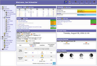
Epesi is an open source, PHP/Ajax framework for rapid development of web based, database driven applications. The framework includes the Epesi CRM multiuser application. It requires PHP 5.x and MySQL or PostgreSQL database server on the server side and can be accessed using any modern browser. Epesi framework and Epesi CRM application are released under MIT license.
The Open Geospatial Consortium Web Coverage Service Interface Standard (WCS) defines Web-based retrieval of coverages – that is, digital geospatial information representing space/time-varying phenomena.

SpatiaLite is a spatial extension to SQLite, providing vector geodatabase functionality. It is similar to PostGIS, Oracle Spatial, and SQL Server with spatial extensions, although SQLite/SpatiaLite aren't based on client-server architecture: they adopt a simpler personal architecture. i.e. the whole SQL engine is directly embedded within the application itself: a complete database simply is an ordinary file which can be freely copied and transferred from one computer/OS to a different one without any special precaution.

The Open Geospatial Consortium (OGC), an international voluntary consensus standards organization, originated in 1994. In the OGC, more than 500 commercial, governmental, nonprofit and research organizations collaborate in a consensus process encouraging development and implementation of open standards for geospatial content and services, sensor web and Internet of Things, GIS data processing and data sharing.
A Web Map Tile Service (WMTS) is a standard protocol for serving pre-rendered or run-time computed georeferenced map tiles over the Internet. The specification was developed and first published by the Open Geospatial Consortium in 2010.


