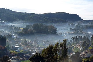
Ooty, officially known as Udhagamandalam, is a city and a municipality in the Nilgiris district of the Indian state of Tamil Nadu. It is located 86 km (53 mi) north west of Coimbatore and 128 km (80 mi) south of Mysore and is the headquarters of the Nilgiris district. It is a popular hill station located in the Nilgiri Hills. It is popularly and lovingly called Queen of Hill Stations and Western Ghats. It was the summer capital of Madras Presidency.

Ernakulam, IPA: [erɐɳɐːguɭɐm]; ISO: Eṟaṇākuḷaṁ, in Malayalam: എറണാകുളം), is one of the 14 districts in the Indian state of Kerala, that takes its name from the eponymous city division in Kochi. It is situated in the central part of the state, spans an area of about 3,000 square kilometres (1,200 sq mi), and is home to over 9% of Kerala's population. Its headquarters are located at Kakkanad. The district includes Kochi, also known as the commercial capital of Kerala, which is famous for its ancient Churches, Hindu temples, synagogues and mosques. The district includes the largest metropolitan region of the state: Greater Cochin. Ernakulam is the district that yields the most revenue and the largest number of industries in the state. Ernakulam is the third most populous district in Kerala, after Malappuram and Thiruvananthapuram. The district also hosts the highest number of international and domestic tourists in Kerala state.

Cuttack district is one of the 30 districts of Odisha state in India. It is located in the coastal part of the state and its administrative headquarters are located in the city of Cuttack. As of 2011 Census, after Ganjam, it is the second most populous district of Odisha, with a population of 2,624,470. The name is an anglicized form of Kataka or Katak meaning Fort – referring to the Barabati Fort. The district is bisected by the river Mahanadi and its numerous distributaries and occupies a large portion of the river's delta. It is bounded by the Angul, Dhenkanal, Nayagarh and Khurda districts to the west while its southern and eastern boundaries touch Puri, Jagatsinghpur, Kendrapara and Jajpur districts.

Kandhamal district is a district in the state of Odisha, India. The district headquarters of the district is Phulbani. Kandhamal is famous for its local turmeric renowned as 'Kandhamal Haldi' which has earned the Geographical indication (GI) tag from Intellectual Property India, an organisation functioning under the auspices of the Ministry of Commerce and Industry (India). It is the district full with natural beauties includes wild animals and birds.

Ranaghat is a city and a municipality in Nadia district in the state of West Bengal, India. It is the headquarters of the Ranaghat subdivision. It is compact but one of the densely populated cities of West Bengal. It is known for its handloom industry, various types of flowers and floriculture and a flower market.

Chengannur is a Municipality in the Alappuzha district of Kerala State, India. It is located in the extreme eastern part of the Alappuzha district, on the banks of Pamba River.
O' Valley or Ouchterlony Valley is a Town Panchayat in the Gudalur Taluk of The Nilgiris district in the Indian state of Tamil Nadu. The name is a contraction of an older name after a James Ouchterlony, who established coffee plantations in the area. This panchayat area is surrounded with beautiful mountains and the waterfalls from the mountains add to the visual treat. One can enjoy by seeing cardamom, clove, pepper, tea and coffee plantations on the way to O' Valley. The place being located between Mudumalai National Park and New Amarambalam Reserved Forest, is famous for its flora and fauna. The place is surrounded by valleys, streams and water falls of which the sound is very soothing and is a mesmeric effect.
Verkilambi is an interior rural area the district of Kanyakumari at the state of Tamil Nadu. This is a grade – I Town panchayat spread in a total area of 15.7 Sq. km and consists of 18 wards, represented by 18 councilors. The Executive officer is the administrative head and the elected Chairman is the political head of this Town Panchayat. This was constituted as Kumarankudy Village, Pathmanapapuram MLA Constituency, Nagercoil MP Constituency. The town is located at a distance of 5 km from Ponmanai Town Panchayat on the East, 5 km from Thiruvattar Town Panchayat on the west. 3 km from Kothanalloor Town Panchayat on the South. This town is located along the Kanyakumari, Thiruvananthapuram, National High way and Colachel – Kulasekaram state high way Road through this TP. This TP Constitutes its village component to talking an area of 3.25 Sq. km up graded as town Panchayat

Chamba is a town in the Chamba district in the Indian state of Himachal Pradesh. According to the 2001 Indian census, Chamba has a population of 20,312 people. Located at an altitude of 1,006 metres (3,301 ft) above mean sea level, the town is situated on the banks of the Ravi River, at its confluence with the Sal River.
Manakkad is a village in Thodupuzha Taluk of Idukki District in Kerala, India, bordering Thodupuzha town on the banks of the Thodupuzha river.
Loutolim or LoutulimLottli pronounced:[lɔːʈlĩː], Portuguese: Loutulim) is a large village of South Goa district in the state of Goa, India. It is an important settlement in the Salcete sub-district.
Marangattupilly is a small village and headquarters of Marangattupally Grama Panchayat in Kottayam district, Kerala. Most of its people are either farmers or engaged in small-scale business. Famous politician K M Mani, was born and brought up in this village. Another famous personality from this village is Santhosh George Kulangara. T K Jose IAS is from this village

Ganderbal district is a district in Indian union territory of Jammu and Kashmir. Ganderbal town is administrative headquarters of district. It was formed in 2007 and has 6 subdistricts (tehsils): Kangan, Ganderbal, Tullamulla, Wakura, Lar, and Gund.

Cherukunnu is a census town in Kannur district in the Indian state of Kerala. Cherukunnu town is located on Valapattanam-Pappinisseri-Pazhayangadi main road, situated to the south of the Pazhayangadi in Kannur District of North Malabar region in Kerala.

Kunhimangalam (കുഞ്ഞിമംഗലം) is a census town situated in the northern coastal part of Kannur District in Kerala state on the outskirt of Payyanur. The population in 2011 was around 19,000 including Hindus, Christians and Muslim residents. The village lies in an agricultural region.

Thirumeni is a village in Kannur district in the Kerala state of India. It is known for its hill station Chathamangalam_Hills. The village has several recently migrated families from various parts of the erstwhile political entity (state) of Travancore who settled here in the famed "Malabar migration period" in the Nineteenth Century. Most of the inhabitants of the village reside in the valley of three major hills by name Chathamangalam Theruvamala alias Alumbumala, Kottathalachimala and Thevarkunnumala. Thirumeni is a small junction with a few government institutions, religious institutions and small shops in int. and is subdivided into smaller villages like Kokkadave, Prapoyil, Chathamangalam (Kannur), Thabore, Muthuvom, Korali, Chattivayal, Thannichal, Paruthikallu etc.

Yana is a village located in forests of the Sirsi and Kumta Uttara Kannada district of Karnataka, India which is known for the unusual karst rock formations. It is located in the Sahyadri mountain range of the Western Ghats, about 60 kilometres (37 mi) from Karwar port, 39 kilometres (24 mi) from Sirsi, and 31 kilometres (19 mi) from Kumta. Yana is one of the wettest villages in the world. It is the cleanest village in Karnataka, and the second cleanest village in India. The two unique rock outcrops near the village are a tourist attraction and easily approachable by a small trek through 0.5 kilometres (0.31 mi) of thick forests from the nearest road head.

Backergunge, Backergunje, Bakarganj, or Bakerganj was a former district of British India. It was the southernmost district of the Dacca Division. The district was located in the swampy lowlands of the vast delta of the Ganges and the Brahmaputra rivers.

Anakkara is a geographic area of around 50 square kilometres that spans across Vandanmedu, Chakkupallam Panchayats in the Udumbanchola Taluk of Idukki District. Anakkara is the administrative capital of Chakkupallam Grama Panchayat and Anakkara Revenue Village. Situated at about 18 Kilometers from Thekkady wildlife sanctuary on the Kumily-Munnar state highway, Anakkara is a fast-growing tourist destination for its unique spice gardens and many picnic spots in and around. It is one of the 36 distinct places identified by Government of India and United Nations Development Programme for exploring and promoting the unique tourism potential of these places.