
Entre Ríos is a central province of Argentina, located in the Mesopotamia region. It borders the provinces of Buenos Aires (south), Corrientes (north) and Santa Fe (west), and Uruguay in the east.

The Province of Santa Fe is a province of Argentina, located in the center-east of the country. Neighboring provinces are from the north clockwise Chaco, Corrientes, Entre Ríos, Buenos Aires, Córdoba, and Santiago del Estero. Together with Córdoba and Entre Ríos, the province is part of the economico-political association known as the Center Region.

Rosario is the largest city in the central Argentine province of Santa Fe. The city is located 300 km (186 mi) northwest of Buenos Aires, on the west bank of the Paraná River. Rosario is the third-most populous city in the country, and is also the most populous city in Argentina that is not a capital. With a growing and important metropolitan area, Greater Rosario has an estimated population of 1,750,000 as of 2020. One of its main attractions includes the neoclassical, Art Nouveau, and Art Deco architecture that has been retained over the centuries in hundreds of residences, houses and public buildings.
Santa Fe de la Vera Cruz is the capital city of the province of Santa Fe, Argentina. It is situated in north-eastern Argentina, near the junction of the Paraná and Salado rivers. It lies 15 kilometres (9.3 mi) from the Hernandarias Subfluvial Tunnel that connects it to the city of Paraná. The city is also connected by canal with the port of Colastiné on the Paraná River. Santa Fe de la Vera Cruz has about 391,164 inhabitants per the 2010 census [INDEC]. The metropolitan area has a population of 653,073, making it the eighth largest in Argentina. The third largest city in Argentina is Rosario, also located in Santa Fe Province.
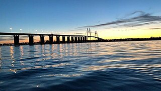
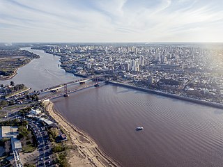
Rosario-Victoria Bridge is the informal name of the physical connection between the Argentine cities of Rosario and Victoria.

Victoria is a city located in the southwestern part of the province of Entre Ríos, Argentina. It is located on the eastern shore of the Paraná River, opposite Rosario, Santa Fe, to which it has been connected since 2003 by the Rosario-Victoria Bridge.

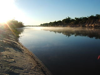
Gualeguay is a city in the province of Entre Ríos, Argentina, on the Gualeguay River, about 226 km from the provincial capital Paraná and 234 km north-west from Buenos Aires. It has a population of about 39,000 inhabitants as per the 2001 census [INDEC]. It should not be confused with Gualeguaychú.

The Ludueña Stream is a small river in the province of Santa Fe, Argentina, which starts near the city of Rosario and flows through it, mostly east-southwards, ending in the Paraná River in the neighbourhood commonly known as Arroyito, near Rosario Central's football stadium.
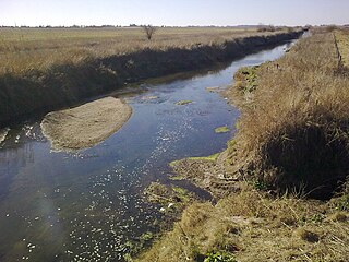
The Saladillo Stream is a small tributary of the Paraná River, that discharges into it between the cities of Rosario and Villa Gobernador Gálvez, in the province of Santa Fe, Argentina. It serves as the political border between these two towns of the Greater Rosario area, and is one of the two important affluents of the Paraná in the area, together with the Ludueña Stream in the north.

The Salado River is a river that crosses several provinces of Argentina, flowing 1,150 kilometres (710 mi) from its source in the Salta Province to end in the Paraná River, in the Santa Fe Province. Because its origin, its flow varies widely within the year, and it can dry out in some parts of its path during the winter. The only important tributary to the river is the Horcones River, which is born in Salta as Cajón River, and joins the Salado in the Santiago del Estero Province.

Rosario lies by the Paraná River, about 300 km upstream from the Argentine capital Buenos Aires; it is a major port and an industrial, commercial and cultural center. It grew from its humble origins to be the third most populated city in Argentina and the largest in the province of Santa Fe. Manuel Belgrano created the flag of Argentina in Rosario.

This article is about the geography and urban structure of Rosario, which is the largest city of the province of Santa Fe, Argentina, and the third most populous in the country, after Córdoba and Buenos Aires. It is located about 300 km (190 mi) north of Buenos Aires, on the Western shore of the Paraná River, and it has about 910,000 inhabitants. It is surrounded by smaller cities and towns that form a metropolitan area with a population of about 1.2 million according to the 2001 census [INDEC].

This article is about the flooding of Santa Fe, capital of the province of Santa Fe, Argentina, in April 2003. Santa Fe is the fifth most populated city in Argentina, and it is surrounded by rivers. The flooding was described as the worst since the city was founded in 1573.
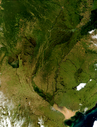
The Río de la Plata basin, more often called the River Plate basin in scholarly writings, sometimes called the Platine basin or Platine region, is the 3,170,000-square-kilometre (1,220,000 sq mi) hydrographical area in South America that drains to the Río de la Plata. It includes areas of southeastern Bolivia, southern and central Brazil, the entire country of Paraguay, most of Uruguay, and northern Argentina. Making up about one fourth of the continent's surface, it is the second largest drainage basin in South America and one of the largest in the world.
The Gualeguay River is one of the major rivers of the Mesopotamic province of Entre Ríos, Argentina. Its source is in the north of the province, in the region between the cities of Federación and San José de Feliciano, and meanders in a general south-southwestward direction across the center of the province for about 350 to 375 kilometres, receiving a large number of tributary streams. It passes by the cities of Villaguay, Rosario del Tala, and Gualeguay, and finally empties into the Río Paraná Ibicuy, a distributary of the Paraná River in the Paraná Delta.

The Rosario Rugby Union is the organisational body that controls the game of rugby union in Rosario, in the province of Santa Fe, Argentina. The rest of Santa Fe province teams are organised under the Unión Santafesina de Rugby.

The Santa Fe Rugby Union is the governing body for rugby union in Santa Fe Province in Argentina. The union runs rugby competitions in the province of Santa Fe with the exception of Rosario clubs, who are part of the Unión de Rugby de Rosario.

The Entre Rios Rugby Union is the organisational body that governs the game of rugby union in Entre Ríos Province, Argentina.