Saladillo Stream

Last updated

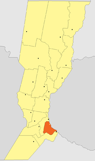
The Saladillo Stream (Spanish, Arroyo Saladillo or Río Saladillo [1] ) is a small tributary of the Paraná River, that discharges into it between the cities of Rosario and Villa Gobernador Gálvez, in the province of Santa Fe , Argentina. It serves as the political border between these two towns of the Greater Rosario area, and is one of the two important affluents of the Paraná in the area, together with the Ludueña Stream in the north.

Spanish language Romance language

Spanish or Castilian, is a Western Romance language that originated in the Castile region of Spain and today has hundreds of millions of native speakers in the Americas and Spain. It is a global language and the world's second-most spoken native language, after Mandarin Chinese.

Tributary stream or river that flows into a main stem river or lake

A tributary or affluent is a stream or river that flows into a larger stream or main stem river or a lake. A tributary does not flow directly into a sea or ocean. Tributaries and the main stem river drain the surrounding drainage basin of its surface water and groundwater, leading the water out into an ocean.

Paraná River river in South America

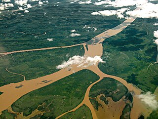
The Paraná River is a river in south Central South America, running through Brazil, Paraguay, and Argentina for some 4,880 kilometres (3,030 mi). It is second in length only to the Amazon River among South American rivers. The name Paraná is an abbreviation of the phrase "para rehe onáva", which comes from the Tupi language and means "like the sea". It merges first with the Paraguay River and then farther downstream with the Uruguay River to form the Río de la Plata and empties into the Atlantic Ocean.

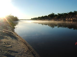
Although in Spanish the Saladillo is called an arroyo, it is not an arroyo in the English sense of a dry or intermittent stream. The Spanish word arroyo means "stream" or "brook", but the Saladillo is a sizable river with a drainage basin encompassing 3,205 square kilometres (1,237 sq mi). Río Saladillo is a variant name in Spanish. [2] Its water services an important area in the southern part of Santa Fe province—both economically for agriculture, and demographically, since its last few kilometres flow through inside a densely populated area (Rosario has over a million residents). The port of Villa Gobernador Gálvez is located on the mouth of the Saladillo.

Arroyo (creek) A dry creek or stream bed with flow after rain

An arroyo, also called a wash, is a dry creek, stream bed or gulch that temporarily or seasonally fills and flows after sufficient rain. Flash floods are common in arroyos following thunderstorms.

River Natural flowing watercourse

A river is a natural flowing watercourse, usually freshwater, flowing towards an ocean, sea, lake or another river. In some cases a river flows into the ground and becomes dry at the end of its course without reaching another body of water. Small rivers can be referred to using names such as stream, creek, brook, rivulet, and rill. There are no official definitions for the generic term river as applied to geographic features, although in some countries or communities a stream is defined by its size. Many names for small rivers are specific to geographic location; examples are "run" in some parts of the United States, "burn" in Scotland and northeast England, and "beck" in northern England. Sometimes a river is defined as being larger than a creek, but not always: the language is vague.

Drainage basin Area of land where precipitation collects and drains off into a common outlet

A drainage basin is any area of land where precipitation collects and drains off into a common outlet, such as into a river, bay, or other body of water. The drainage basin includes all the surface water from rain runoff, snowmelt, and nearby streams that run downslope towards the shared outlet, as well as the groundwater underneath the earth's surface. Drainage basins connect into other drainage basins at lower elevations in a hierarchical pattern, with smaller sub-drainage basins, which in turn drain into another common outlet.

Most of the Saladillo is canalized, and parts are channelized, as are its main tributaries. It requires periodic dredging to support its massive use for agriculture, which in turn degrades the water quality with pollutants such as pesticides and fertilizers, and tends to fill the river with sediments produced by erosion. The Saladillo's riparian zone is subject to flooding. The lower course is an urban stream, and is polluted by industrial and domestic waste.

Dredging excavation of sediment, usually under water

Dredging is the operation of removing material from one part of the water environment and relocating it to another. In all but a few situations the excavation is undertaken by a specialist floating plant, known as a dredger. Dredging is carried out in many different locations and for many different purposes, but the main objectives are usually to recover material that has some value or use, or to create a greater depth of water.

Water quality chemical, physical, biological, and radiological characteristics of water

Water quality refers to the chemical, physical, biological, and radiological characteristics of water. It is a measure of the condition of water relative to the requirements of one or more biotic species and or to any human need or purpose. It is most frequently used by reference to a set of standards against which compliance, generally achieved through treatment of the water, can be assessed. The most common standards used to assess water quality relate to health of ecosystems, safety of human contact, and drinking water.

Pollutant substance or energy source damaging to the environment

A pollutant is a substance or energy introduced into the environment that has undesired effects, or adversely affects the usefulness of a resource. A pollutant may cause long- or short-term damage by changing the growth rate of plant or animal species, or by interfering with human amenities, comfort, health, or property values. Some pollutants are biodegradable and therefore will not persist in the environment in the long term. However, the degradation products of some pollutants are themselves polluting such as the products DDE and DDD produced from degradation of DDT.

See also

Coordinates: 32°59′54″S60°36′42″W / 32.99833°S 60.61167°W / -32.99833; -60.61167 [3]

Geographic coordinate system Coordinate system

A geographic coordinate system is a coordinate system that enables every location on Earth to be specified by a set of numbers, letters or symbols. The coordinates are often chosen such that one of the numbers represents a vertical position and two or three of the numbers represent a horizontal position; alternatively, a geographic position may be expressed in a combined three-dimensional Cartesian vector. A common choice of coordinates is latitude, longitude and elevation. To specify a location on a plane requires a map projection.

Related Research Articles

Entre Ríos Province Province of Argentina

Entre Ríos is a central province of Argentina, located in the Mesopotamia region. It borders the provinces of Buenos Aires (south), Corrientes (north) and Santa Fe (west), and Uruguay in the east.

Villa Constitución City in Santa Fe, Argentina

Villa Constitución is a city in the province of Santa Fe, Argentina, and the head town of the Constitución Department. It is located on the south-western banks of the Paraná River between the courses of the Arroyo Pavón and the Arroyo del Medio, about 214 km south from the provincial capital, the city of Santa Fe, and 50 km from Rosario. It has a population of more than 47,374 inhabitants as per the 2010 census [INDEC].

Greater Rosario Argentine metropolitan area

Greater Rosario is the metropolitan area of the city of Rosario, in the province of Santa Fe, Argentina. This metropolis has a population of about 1.3 million thus being Argentina's third most populated urban settlement, after Buenos Aires and Córdoba.

Rosario Department Department in Santa Fe, Argentina

The Rosario Department is an administrative subdivision (departamento) of the province of Santa Fe, Argentina. It is located on the south of the province, with its eastern border coinciding with the provincial border along the Paraná River. It has an area of 1,890 square kilometres (730 sq mi) and a population of 1.3 million, with a population density of about 700 inhabitants/km². This department is the most populated in the province.

Ludueña Stream river in Argentina

The Ludueña Stream is a small river in the province of Santa Fe, Argentina, which starts near the city of Rosario and flows through it, mostly east-southwards, ending in the Paraná River in the neighbourhood commonly known as Arroyito, near Rosario Central's football stadium.

Villa Gobernador Gálvez City in Santa Fe, Argentina

Villa Gobernador Gálvez is a city in the province of Santa Fe, Argentina, located on the western ravine of the Paraná River, within the metropolitan area of Greater Rosario. It has 74,509 inhabitants per the 2001 census [INDEC]. It is separated from Rosario, to the north, by the Saladillo Stream. It is the fourth most populated city in the province and the second in the metropolitan area.

Salado River (Argentina) river in Argentina

The Salado River is a river that crosses several provinces of Argentina, flowing 1,150 kilometres (710 mi) from its source in the Salta Province to end in the Paraná River, in the Santa Fe Province. Because its origin, its flow varies widely within the year, and it can dry out in some parts of its path during the winter. The only important tributary to the river is the Horcones River, which is born in Salta as Cajón River, and joins the Salado in the Santiago del Estero Province.

History of Rosario

Rosario lies by the Paraná River, about 300 km upstream from the Argentine capital Buenos Aires; it is a major port and an industrial, commercial and cultural center. It grew from its humble origins to be the third most populated city in Argentina and the largest in the province of Santa Fe. Manuel Belgrano created the flag of Argentina in Rosario.

Geography of Rosario Argentine metropolitan area

This article is about the geography and urban structure of Rosario, which is the largest city of the province of Santa Fe, Argentina, and the third most populous in the country, after Córdoba and Buenos Aires. It is located about 300 km (190 mi) north of Buenos Aires, on the Western shore of the Paraná River, and it has about 910,000 inhabitants. It is surrounded by smaller cities and towns that form a metropolitan area with a population of about 1.2 million according to the 2001 census [INDEC].

The Carcarañá River is a river in Argentina. It begins at the confluence of the Río Tercero and the Saladillo River in the south-east of the province of Córdoba and flows eastward into the province of Santa Fe, which it crosses.

Tercero River river in Argentina

The Tercero River, also known as Ctalamochita, is the river of the Córdoba Province in Argentina with the most important water flow, 27.17 cubic metres per second (959 cu ft/s). It starts near the Calamuchita Valley, becomes navigable for boats of small to medium sizes as it flows through the plains, and flows 307 kilometres (191 mi) before reaching the Carcarañá River.

Cuarto River river in Argentina

The Cuarto River is a river of Argentina which crosses the southern part of the Province of Córdoba, and merges with the Tercero River to form the Carcarañá River. The Cuarto River is also known as Cochancharava, the name given to it by the Ranquel Indians.

Constitución Department, Santa Fe Department in Santa Fe, Argentina

The Constitución Department is an administrative subdivision (departamento) of the province of Santa Fe, Argentina. It is located on the south of the province. It has about 83,000 inhabitants as per the 2001 census [INDEC]. Its head town is the city of Villa Constitución.

Paraná Delta river delta in Argentina

The Paraná Delta is the delta of the Paraná River in Argentina and it consists of several islands known as the Islas del Paraná. The Paraná flows north–south and becomes an alluvial basin between the Argentine provinces of Entre Ríos, Santa Fe and Buenos Aires then emptying into the Río de la Plata.

Gualeguay River river in Argentina

The Gualeguay River is one of the major rivers of the Mesopotamic province of Entre Ríos, Argentina. Its source is in the north of the province, in the region between the cities of Federación and San José de Feliciano, and meanders in a general south-southwestward direction across the center of the province for about 350 to 375 kilometres, receiving a large number of tributary streams. It passes by the cities of Villaguay, Rosario del Tala, and Gualeguay, and finally empties into the Río Paraná Ibicuy, a distributary of the Paraná River in the Paraná Delta.

The San Javier River is an anabranch of the Paraná River in the province of Santa Fe, Argentina.

San Martín Street (Rosario) Rosario

San Martín Street is an important street in Rosario, Santa Fe Province, Argentina. It runs north–south through the center of the city, from the coastal avenue by the Paraná River to the southern limit of the urbanized area. It was originally named Calle del Puerto ; the name was changed in 1887 to honour Independence War hero General José de San Martín.

The Litoral region of Argentina underwent heavy rainstorms in the early autumn season of 2007. Starting in late March and ending in mid-April, the rains caused several major rivers to rise and/or overflow their banks, partly or completely flooded many towns and large cities, ruined a significant part of the crops in a wide region, and severely damaged the physical infrastructure. At least 15 people were killed as a result of the flooding.

References