Related Research Articles

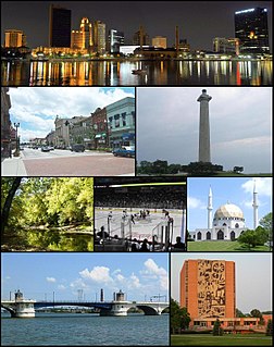
Toledo is a city in and the county seat of Lucas County, Ohio, United States. A major Midwestern United States port city, Toledo is the fourth-most-populous city in the U.S. state of Ohio, after Columbus, Cleveland, and Cincinnati, and according to the 2010 census, the 71st-largest city in the United States. With a population of 274,975, it is the principal city of the Toledo metropolitan area. It also serves as a major trade center for the Midwest; its port is the fifth busiest in the Great Lakes and 54th biggest in the United States. The city was founded in 1833 on the west bank of the Maumee River, and originally incorporated as part of Monroe County, Michigan Territory. It was re-founded in 1837, after the conclusion of the Toledo War, when it was incorporated in Ohio.
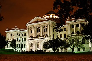
Lucas County is a county located in the northwestern part of the U.S. state of Ohio. It is bordered to the east by Lake Erie, and to the southeast by the Maumee River, which runs to the lake. As of the 2010 census, the population was 441,815. Its county seat is Toledo, located at the mouth of the Maumee River on the lake. The county was named for Robert Lucas, 12th governor of Ohio, in 1835 during his second term. Its establishment provoked the Toledo War conflict with the Michigan Territory, which claimed some of its area.

Maumee is a city in Lucas County, Ohio, United States. Located along the Maumee River, it is about 10 miles southwest of Toledo. The population was 14,286 at the 2010 census. Maumee was declared an All-America City by the National Civic League in June 2006.

Sylvania is a city in Lucas County, Ohio, United States. The population was 18,971 at the 2010 census. Sylvania is a suburb of Toledo, and encompassed by Sylvania Township. Its northern border is the southern border of the state of Michigan.

Waterville is a city in Lucas County, Ohio, United States, along the Maumee River, a suburb of Toledo. The population was 5,523 at the 2010 census.

The Maumee River is a river running in the United States Midwest from northeastern Indiana into northwestern Ohio and Lake Erie. It is formed at the confluence of the St. Joseph and St. Marys rivers, where Fort Wayne, Indiana, has developed, and meanders northeastwardly for 137 miles (220 km) through an agricultural region of glacial moraines before flowing into the Maumee Bay of Lake Erie. The city of Toledo is located at the mouth of the Maumee. The Maumee was designated an Ohio State Scenic River on July 18, 1974. The Maumee watershed is Ohio’s breadbasket; it is two-thirds farmland, mostly corn and soybeans. It is the largest watershed of any of the rivers feeding the Great Lakes, and supplies five percent of Lake Erie’s water.

Maumee Bay on Lake Erie is located in the U.S. state of Ohio, just east of the city of Toledo. The bay and the surrounding wetlands form most of the Maumee River basin, and in 1975 part of the area was incorporated into Maumee Bay State Park. The park is not huge, covering 1,450 acres (5.9 km2), but its wetlands feature some of the best bird watching in the United States. The Maumee Bay area is a popular vacation spot in the Midwest, featuring several resorts and a golf course.

The Ottawa River, also known as Ottawa Creek, is a short river, approximately 20 miles (32 km) long, in northwest Ohio and southeast Michigan in the United States. It drains an area on the Ohio-Michigan border along the eastern and northern fringes of the city of Toledo, goes through Ottawa Hills, and empties directly into Lake Erie. It is one of two rivers in northwestern Ohio that share the same name, along with the Ottawa River that is a tributary of the Auglaize River. The upper 4 miles (6 km) of the river in Michigan north of Sylvania, Ohio is called North Tenmile Creek on federal maps, while another branch rising in Fulton County, Ohio, is called Tenmile Creek.

The Sandusky River is a tributary to Lake Erie in north-central Ohio in the United States. It is about 133 miles (214 km) long and flows into Lake Erie at the southwest side of Sandusky Bay.
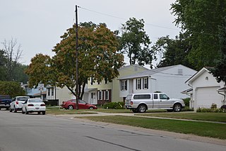
Washington Township is one of the eleven townships of Lucas County, Ohio, United States. The 2010 census found 3,278 people in the township.
The Toledo Metropolitan Area, or Greater Toledo, is a metropolitan area centered on the American city of Toledo, Ohio. As of the 2010 census, the metropolitan statistical area (MSA) had a population of 651,429. It is the sixth-largest metropolitan area in the state of Ohio, behind Cincinnati–Northern Kentucky, Cleveland, Columbus, Dayton, and Akron.

Col. James M. Schoonmaker, formerly Willis B. Boyer, is a lake freighter that served as a commercial vessel on the Great Lakes for much of the 20th Century. Named for Medal of Honor recipient James Martinus Schoonmaker, it is currently a museum ship in Toledo, Ohio.

Harvard Terrace is a historic neighborhood in Toledo, Ohio; it is "bordered by Amherst Drive, Broadway, Glendale Avenue, and the Anthony Wayne Trail. It includes 435 residences, many of them designed by architects and built in the early 1900s."

Farnsworth Metropark is a regional park located in Waterville, Ohio that is part of the Toledo Metroparks. The long narrow parks sits on the western shore of the Maumee River with a view of several islands, including Missionary, Butler and Indian islands, all of which are owned by the State of Ohio.

Toledo Lucas County Public Library is a public library system located in Toledo, Ohio.
Downtown Toledo is the central business district of Toledo, Ohio. The area has seen a huge revival in the last few years with new retail, restaurants, entertainment venues, etc. moving into what had been, for many, considered a somewhat of a forgotten ghost town for years. Both the Warehouse District and the area surrounding the Huntington Center have been areas of recent growth.

The Oliver House is a historic hotel building in Toledo, Ohio designed by architect Isaiah Rogers and opened in 1859. It was converted to industrial use in the 20th Century, and is now home to the Maumee Bay Brewing Company and its brew pub, as well as a patisserie, restaurants, event spaces, a theater company, art gallery, and residential apartments. It is listed on the National Register of Historic Places. as Successful Sales.
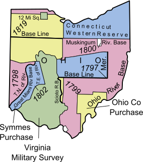
The Twelve Mile Square Reservation, also called the Twelve Mile Square Reserve, was a tract of land in Ohio ceded by Indians to the United States of America in the Treaty of Greenville in 1795. This particular area of land immediately surrounding Fort Miami was considered to be of strategic importance by the United States government representatives. It was subsequently surveyed in a manner different from surrounding land, and lots sold, or granted, to settlers.

Point Place is a neighborhood in North Toledo, Ohio. Point Place was originally part of Washington Township, Lucas County in the 1800s, and was annexed into the city of Toledo, Ohio in 1937. Point Place is surrounded by the Ottawa River, Lake Erie, the Maumee Bay and the Maumee River.

Richfield Center is an unincorporated community in Lucas County, in the U.S. state of Ohio.
References
- ↑ Waggoner, Clark (1888). History of the City of Toledo and Lucas County, Ohio. Munsell & Company. p. 843.
- ↑ Scribner, Harvey (1910). Memoirs of Lucas County and the City of Toledo: From the Earliest Historical Times Down to the Present, Including a Genealogical and Biographical Record of Representative Families. Western Historical Association. p. 83.
Municipalities and communities of Lucas County, Ohio, United States | ||
|---|---|---|
| Cities |  | |
| Villages | ||
| Townships | ||
| CDPs | ||
| Unincorporated communities | ||
| Ghost towns | ||
| Footnotes | ‡This populated place also has portions in an adjacent county or counties | |
Coordinates: 41°35′50″N83°36′10″W / 41.59722°N 83.60278°W
| This Lucas County, Ohio state location article is a stub. You can help Wikipedia by expanding it. |