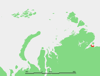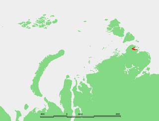
The Laptev Sea is a marginal sea of the Arctic Ocean. It is located between the northern coast of Siberia, the Taimyr Peninsula, Severnaya Zemlya and the New Siberian Islands. Its northern boundary passes from the Arctic Cape to a point with co-ordinates of 79°N and 139°E, and ends at the Anisiy Cape. The Kara Sea lies to the west, the East Siberian Sea to the east.
Nikolay Nikolayevich Urvantsev was a Soviet geologist and explorer. He was born in the town of Lukoyanov in the Lukoyanovsky Uyezd of the Nizhny Novgorod Governorate of the Russian Empire to the family of a merchant. He graduated from the Tomsk Engineering Institute in 1918.

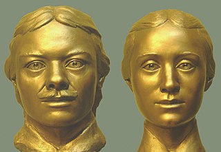
Vasili Vasilyevich Pronchishchev was a Russian explorer.

The Khatanga Gulf or Khatanga Bay is a large tidal estuary in the Laptev Sea. It is relatively narrow, its length being 220 kilometres (140 mi) with a maximum width of 54 kilometres (34 mi).

Vladimir Ivanovich Voronin was a Soviet Navy captain, born in Sumsky Posad, in the present Republic of Karelia, Russia. In 1932 he commanded the expedition of the Soviet icebreaker A. Sibiryakov which made the first successful crossing of the Northern Sea Route in a single navigation without wintering. This voyage was organized by the All-Union Arctic Institute.

The Komsomolskaya Pravda Islands are an archipelago in the far north of the Russian Federation. The islands are uninhabited and are covered with tundra vegetation, shingle and ice.

The icebreaker Fyodor Litke was active in the Soviet era in the Arctic, until the late 1950s. It was built in 1909 in England for the Saint Lawrence River service and initially named CGC Earl Grey after Albert Grey, Governor General of Canada. After four years in Canada it was sold to the Russian government and eventually renamed Fyodor Litke in honour of the Arctic explorer Fyodor Petrovich Litke.

Operation Wonderland was an operation from 16 to 30 August 1942 by the Kriegsmarine in the Barents Sea and the Kara Sea off the Arctic coast of the Soviet Union. The operation was an attack on Soviet shipping using the Northern Sea Route which ran along the Soviet Arctic coast from the Bering Strait, westwards along Siberia to the Kara Sea. The operation was the first part of a campaign to dominate the seas of the western Arctic. Reports from Japanese naval intelligence alerted the Germans to the sailing of a convoy, EON-18.

Icebreaker Vaygach was an icebreaking steamer of moderate size built for the Russian Imperial Navy at Saint Petersburg in 1909. She was named after Vaygach Island in the Russian Arctic.
Steamer Pravda was a Soviet merchant freighter of about 3,100 tonnes displacement, which was active in the Soviet Arctic during the 1930s. This ship had been normally used for carrying timber. It was named after Soviet newspaper Pravda.

The Yenisey Gulf is a large and long estuary through which the lower Yenisey flows into the Kara Sea.

Taymyr Island is a large island in the coast of the Kara Sea. Its length is 33 km (21 mi) and its average width about 10 km (6.2 mi). This island is located west of the Taymyr Gulf in an area of skerries right off the western coast of the Taymyr Peninsula. The narrow strait between Taymyr island and the Siberian coast is called Proliv Taymyrskiy It is about 3 km (1.9 mi) wide on average.

Nansen Island, is a long and narrow island in the coast of the Kara Sea. Its length is 21 km (13 mi) and its average width about 2.5 km (1.6 mi). This island is located in an area of skerries right off the western coast of the Taymyr Peninsula.

Nordvik Bay is a gulf in the Laptev Sea in the north of Russia. Lat 73° 45' and long 112°.

Kozhevnikova Bay is a gulf in the southern shore the Khatanga Gulf, Laptev Sea, located west of the Hara Tumus Peninsula. Its coast is desolate as there is no vegetation except for tundra. Since its shores receive alluvial deposits eroded from the cliffs located north of the Khatanga Gulf, they are quite stable.

The Saint Peter Islands, also known as Saint Petra Islands or Petra Islands are two islands covered with tundra vegetation, shingle and ice. These islands, as well as some other islands nearby were originally named after Christian Apostles. The climate is Arctic and severe with frequent blizzards in the winter. The sea surrounding these Islands is covered with fast ice most of the year and is obstructed by pack ice even in the summer, so that these islands are merged with the mainland and animals can go across the ice.

The Simsa Bay or Bay of Sims is a gulf in the Laptev Sea on the coast of the Taymyr Peninsula.

The Shelonsky Islands is an island group in the Sakha Republic (Yakutia), Russian Federation.
Providence Bay is a fjord in the southern coast of the Chukchi Peninsula of northeastern Siberia. It was a popular rendezvous, wintering spot, and provisioning spot for whalers and traders in the nineteenth and early twentieth centuries. Emma Harbor is a large sheltered bay in the eastern shore of Providence Bay. Provideniya and Ureliki settlements and Provideniya Bay Airport stand on the Komsomolskaya Bay. Plover Bay in English sources sometimes refers specifically to the anchorage behind Napkum Spit within Providence Bay but was commonly used as a synonym for Providence Bay; Russian 19th century sources used the term for an anchorage within Providence Bay.

Maria Pronchishcheva, also known as Tatiana Fyodorovna Pronchishcheva, was a Russian explorer. She is considered the first female polar explorer.


