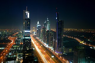
The 21st Century Tower is a 55-story skyscraper along the Sheikh Zayed Road in Dubai. When it was completed in 2003 it took the title of the world's tallest residential building, ultimately being surpassed by the Eureka Tower in Melbourne, Australia and the Q1 tower in Australia's Gold Coast.

Lycée Michel Rodange, abbreviated to LMRL, is a high school in Luxembourg City, in southern Luxembourg. It is located on Campus Geesseknäppchen, along with several other educational institutions, most of which, including Lycée Michel Rodange, is in the quarter of Hollerich, in the south-west of the city.

Shamiram, is a village in the Aragatsotn Province of Armenia. It is mostly populated by Yazidis. The village is named after the Assyrian legendary queen Semiramis.

Wólka Rejowiecka is a village in the administrative district of Gmina Rejowiec, within Chełm County, Lublin Voivodeship, in eastern Poland. It lies approximately 2 kilometres (1 mi) north of Rejowiec, 16 km (10 mi) west of Chełm, and 52 km (32 mi) east of the regional capital Lublin.
Darżkowo is a village in the administrative district of Gmina Kołczygłowy, within Bytów County, Pomeranian Voivodeship, in northern Poland. It lies approximately 6 kilometres (4 mi) north-west of Kołczygłowy, 27 km (17 mi) north-west of Bytów, and 96 km (60 mi) west of the regional capital Gdańsk.
Siedlec-Kolonia is a village in the administrative district of Gmina Łęczyca, within Łęczyca County, Łódź Voivodeship, in central Poland.
Teklin is a village in the administrative district of Gmina Żelechlinek, within Tomaszów Mazowiecki County, Łódź Voivodeship, in central Poland. It lies approximately 6 kilometres (4 mi) east of Żelechlinek, 24 km (15 mi) north of Tomaszów Mazowiecki, and 45 km (28 mi) east of the regional capital Łódź.
Kościejów is a village in the administrative district of Gmina Racławice, within Miechów County, Lesser Poland Voivodeship, in southern Poland. It lies approximately 4 kilometres (2 mi) east of Racławice, 18 km (11 mi) east of Miechów, and 39 km (24 mi) north-east of the regional capital Kraków.
Niedomice is a village in the administrative district of Gmina Żabno, within Tarnów County, Lesser Poland Voivodeship, in southern Poland. It lies approximately 3 kilometres (2 mi) south of Żabno, 12 km (7 mi) north-west of Tarnów, and 69 km (43 mi) east of the regional capital Kraków.
Zygmuntów is a village in the administrative district of Gmina Fałków, within Końskie County, Świętokrzyskie Voivodeship, in south-central Poland.
Legacz is a village in the administrative district of Gmina Stanisławów, within Mińsk County, Masovian Voivodeship, in east-central Poland.

Janczewice is a village in the administrative district of Gmina Lesznowola, within Piaseczno County, Masovian Voivodeship, in east-central Poland. It lies approximately 3 kilometres (2 mi) north of Lesznowola, 8 km (5 mi) north-west of Piaseczno, and 13 km (8 mi) south of Warsaw.
Ostrowce is a village in the administrative district of Gmina Iłów, within Sochaczew County, Masovian Voivodeship, in east-central Poland.
Sarnowa-Kolonia is a village in the administrative district of Gmina Ślesin, within Konin County, Greater Poland Voivodeship, in west-central Poland.
Doły is a settlement in the administrative district of Gmina Sztutowo, within Nowy Dwór Gdański County, Pomeranian Voivodeship, in northern Poland. It lies approximately 7 kilometres (4 mi) south-east of Sztutowo, 11 km (7 mi) north-east of Nowy Dwór Gdański, and 41 km (25 mi) east of the regional capital Gdańsk.
Janów is a village in the administrative district of Gmina Elbląg, within Elbląg County, Warmian-Masurian Voivodeship, in northern Poland. It lies approximately 6 kilometres (4 mi) east of Elbląg and 76 km (47 mi) north-west of the regional capital Olsztyn.
Bogdaniec is a settlement in the administrative district of Gmina Tolkmicko, within Elbląg County, Warmian-Masurian Voivodeship, in northern Poland. It lies approximately 8 kilometres (5 mi) south-west of Tolkmicko, 21 km (13 mi) north of Elbląg, and 88 km (55 mi) north-west of the regional capital Olsztyn.
Frączkowo is a village in the administrative district of Gmina Barciany, within Kętrzyn County, Warmian-Masurian Voivodeship, in northern Poland, close to the border with the Kaliningrad Oblast of Russia. It lies approximately 8 kilometres (5 mi) north-west of Barciany, 23 km (14 mi) north of Kętrzyn, and 76 km (47 mi) north-east of the regional capital Olsztyn.
Golinka is a settlement in the administrative district of Gmina Stargard, within Stargard County, West Pomeranian Voivodeship, in north-western Poland.

Edwand is a hamlet in central Alberta, Canada within Smoky Lake County. It is located 4 kilometres (2.5 mi) north of Highway 28, approximately 104 kilometres (65 mi) northeast of Edmonton.