Marka, Malawi

Last updated
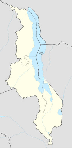
Marka
Malawi adm location map.svg
Red pog.svg
Marka
Location in Malawi
Coordinates: 17°07′11.8″S35°13′36.8″E / 17.119944°S 35.226889°E / -17.119944; 35.226889 Coordinates: 17°07′11.8″S35°13′36.8″E / 17.119944°S 35.226889°E / -17.119944; 35.226889
CountryFlag of Malawi.svg  Malawi
Region Southern Region
Time zone +2
Climate Cwa

Marka is a town [1] located in Nsanje District in Malawi. It is the southernmost location in the country, serving as a border post [2] for road and rail control between Malawi and Mozambique. [3] [4]

The Mozambican town of Vila Nova de Fronteira is conurbed with Marka. In addition, Marka is part of a large conurbation zone that extends northwards, passing through the city of Nsanje to the city of Bangula.[ citation needed ]
Transport

The M1 road is the main source of transportation that connects the district to its neighboring district, Chikwawa. Before 2010, transportation to the lower shire district was difficult especially during rainy season.

The town had a railway station on the Sena railway, part of the Malawi Railways. The railway through Marka that connects Nsanje and Blantyre with Beira was severely disrupted by the Mozambique Civil War and remains closed. In the late 1990's, part of the railway was damaged at Chiromo bridge near Bangula. Due to this damage, the train station at Nsanje was closed. [4]

Related Research Articles

Transport in Malawi

Transportation in Malawi is poorly developed. The country of almost 14 million has 39 airports, 6 with paved runways and 33 with unpaved runways. It has 797 kilometres of railways, all narrow-gauge and about 45 percent of its roads are paved. Though it is landlocked, Malawi also has 700 km (435 mi) of waterways on Lake Malawi and along the Shire River.

Mozambique Country in Southeastern Africa

Mozambique, officially the Republic of Mozambique, is a country located in Southeastern Africa bordered by the Indian Ocean to the east, Tanzania to the north, Malawi and Zambia to the northwest, Zimbabwe to the west, and Eswatini (Swaziland) and South Africa to the southwest. The sovereign state is separated from the Comoros, Mayotte and Madagascar by the Mozambique Channel to the east. The capital and largest city of Mozambique is Maputo.

Transport in Mozambique

Modes of transport in Mozambique include rail, road, water, and air. There are rail links serving principal cities and connecting the country with Malawi, Zimbabwe and South Africa. There are over 30,000km of roads, but much of the network is unpaved.

Portuguese Mozambique 1498–1975 Portuguese possession in East Africa

Portuguese Mozambique or Portuguese East Africa were the common terms by which Mozambique was designated during the period in which it was a Portuguese colony. Portuguese Mozambique originally constituted a string of Portuguese possessions along the south-east African coast, and later became a unified colony, which now forms the Republic of Mozambique.

Nsanje Place in Southern Region, Malawi

Nsanje is the main city in Nsanje District within the Southern Region of Malawi.

Beira, Mozambique Place in Sofala Province, Mozambique

Beira is the capital and largest city of Sofala Province, where the Pungwe River meets the Indian Ocean, in the central region of Mozambique. It is the fourth-largest city by population in Mozambique, after Maputo, Matola and Nampula. Beira had a population of 397,368 in 1997, which grew to 530,604 in 2019. A coastal city, it holds the regionally significant Port of Beira, which acts as a gateway for both the central interior portion of the country as well as the land-locked nations of Zimbabwe, Zambia and Malawi.

Gurúè Place in Zambezia, Mozambique

Gurúè is a town located in the northern part of Mozambique, near the center of the province of Zambezia. It serves as the principal town of Gurué District, and is Mozambique's largest tea estate. According to the 2007 census, the town had a population of 145,466, an increase from the 99,335 inhabitants counted in the 1997 census.

Quelimane Place in Zambezia Province, Mozambique

Quelimane is a seaport in Mozambique. It is the administrative capital of the Zambezia Province and the province's largest city, and stands 25 km (16 mi) from the mouth of the Rio dos Bons Sinais. The river was named when Vasco da Gama, on his way to India, reached it and saw "good signs" that he was on the right path. The town was the end point of David Livingstone's west-to-east crossing of south-central Africa in 1856. Portuguese is the official language of Mozambique, and many residents of the areas surrounding Quelimane speak Portuguese. The most common local language is Chuabo. Quelimane, along with much of Zambezia Province, is extremely prone to floods during Mozambique's rainy season. The most recent bout of severe flooding took place in January 2007.

Nsanje District District of Malawi

Nsanje is a district in the Southern Region of Malawi. The capital is Nsanje. The district covers an area of 1,942 square kilometres (750 sq mi) and has a population of 194,924.

Cuamba Place in Niassa Province, Mozambique

Cuamba is a city and district of Niassa Province in Mozambique, lying north west of Mount Namuli. Before independence the town was known as Nova Freixo.

Malawi Railways

Malawi Railways was a government corporation that ran the national rail network of Malawi, Africa, until privatisation in 1999. With effect from 1 December 1999, the Central East African Railways consortium led by Railroad Development Corporation won the right to operate the network. This was the first rail privatisation in Africa which did not involve a parastatal operator.

Port of Beira Port in Mozambique

The Port of Beira is a Mozambican port located in the city of Beira, capital of the Sofala Province. It is located in Sofala Bay, which forms a huge complex with the mouth of the Pungoe River, known as the Beira estuary, facing the Mozambique Channel. It is the second largest port in Mozambique, built to replace the port of Old Sofala in the 1890s.

Dona Ana Bridge

The Dona Ana Bridge spans the lower Zambezi River between the towns of Vila de Sena and Mutarara in Mozambique, effectively linking the two halves of the country. It was originally constructed as a railway bridge to link Malawi and the Moatize coal fields to the port of Beira.

Mozambique Ports and Railways

Portos e Caminhos de Ferro de Moçambique is a state-owned company that oversees the railway system of Mozambique and its connected ports.

Railway stations in Mozambique include:

Malawi Railways is the national rail network in Malawi, run by a government corporation until privatisation in 1999. As of 1 December 1999 the Central East African Railways, a consortium led by Railroad Development Corporation, won the right to operate the network.

Bangula is a town of about 5000 population in southern Malawi. There is also a commune of the same name. Its elevation is 100m. It is located on the western bank of the Shire River, near the confluence of the Shire and Ruo River. After extensive flooding in Chiromo, the municipalities were moved to Bangula. The name Bangula is roughly translated to 'place where the lions roar' – although few to no lions exist in the area anymore.

Malawi–Mozambique relations Bilateral diplomatic relations

Malawi–Mozambique relations refers to the current and historical relationship between the countries of Malawi and Mozambique. As Malawi shares a large border with Mozambique, much of the substance of their foreign relations pertain to the border separating the two nations. Both of the sovereign states have amicably agreed that lacustrine borders on Lake Malawi remain the largest priority between the two countries, as the exploitation of natural resources within the waters of Lake Malawi remain an issue the two countries continue to resolve. The moment considered an act of generosity and sympathy within the two countries relations is when, during the Mozambique Civil War, Malawi housed over one million Mozambican refugees between 1985 and 1995. After this gesture, Malawian relations with Mozambique crumbled under the tenure of Bingu wa Mutharika, notoriously reaching a nadir when Malawian police launched a raid into Mozambique's territory.

Nacala railway

Nacala railway, also known as Northern Corridor railway and Nacala Corridor railway, is a railway line that operates in northern Mozambique on a 912 kilometres (567 mi) line that runs west from the port city of Nacala, crossing the central region of Malawi, connecting with the coal belt of Moatize, in northwest Mozambique. It is connected to the Dona Ana-Moatize railway branch and the Sena railway (Chipata-Lilongwe-Blantyre-Nhamayabue-Dondo). It also has a 262 kilometres (163 mi) branch line from Cuamba to Lichinga.

Sena railway

Sena railway, also called Shire Highlands railway, Dondo-Malawi railway and North-South Malawi railway, is a railway that connects Dondo, Mozambique, to Chipata, in Zambia. It is c. 1000 km long, in a 1067 mm gauge.

References

  1. Malemia applauds Malawi govt for K11.1bn Nsanje-Marka road construction. Nyasa Times. 27 July 2019.
  2. Physical Addresses. Department of Immigration. Republic of Malawi.
  3. Delays rocks Railway project. The Nation. 19 June 2021.
  4. 1 2 "PR lança 1ª pedra para reconstrução da linha férrea Dona Ana/ Vila Nova da Fronteira que liga Moçambique e o Malawi". Rádio Moçambique. 29 May 2021. Retrieved 31 May 2021.