Related Research Articles

Geophysics is a subject of natural science concerned with the physical processes and physical properties of the Earth and its surrounding space environment, and the use of quantitative methods for their analysis. Geophysicists, who usually study geophysics, physics, or one of the Earth sciences at the graduate level, complete investigations across a wide range of scientific disciplines. The term geophysics classically refers to solid earth applications: Earth's shape; its gravitational, magnetic fields, and electromagnetic fields ; its internal structure and composition; its dynamics and their surface expression in plate tectonics, the generation of magmas, volcanism and rock formation. However, modern geophysics organizations and pure scientists use a broader definition that includes the water cycle including snow and ice; fluid dynamics of the oceans and the atmosphere; electricity and magnetism in the ionosphere and magnetosphere and solar-terrestrial physics; and analogous problems associated with the Moon and other planets.

Earth's magnetic field, also known as the geomagnetic field, is the magnetic field that extends from Earth's interior out into space, where it interacts with the solar wind, a stream of charged particles emanating from the Sun. The magnetic field is generated by electric currents due to the motion of convection currents of a mixture of molten iron and nickel in Earth's outer core: these convection currents are caused by heat escaping from the core, a natural process called a geodynamo.

Harry Hammond Hess was an American geologist and a United States Navy officer in World War II who is considered one of the "founding fathers" of the unifying theory of plate tectonics. He published theories on sea floor spreading, specifically on relationships between island arcs, seafloor gravity anomalies, and serpentinized peridotite, suggesting that the convection in the Earth's mantle is the driving force behind this process.

In geophysics, the free-air gravity anomaly, often simply called the free-air anomaly, is the measured gravity anomaly after a free-air correction is applied to account for the elevation at which a measurement is made. It does so by adjusting these measurements of gravity to what would have been measured at a reference level, which is commonly taken as mean sea level or the geoid.
The gravity anomaly at a location on the Earth's surface is the difference between the observed value of gravity and the value predicted by a theoretical model. If the Earth were an ideal oblate spheroid of uniform density, then the gravity measured at every point on its surface would be given precisely by a simple algebraic expression. However, the Earth has a rugged surface and non-uniform composition, which distorts its gravitational field. The theoretical value of gravity can be corrected for altitude and the effects of nearby terrain, but it usually still differs slightly from the measured value. This gravity anomaly can reveal the presence of subsurface structures of unusual density. For example, a mass of dense ore below the surface will give a positive anomaly due to the increased gravitational attraction of the ore.

Magnetotellurics (MT) is an electromagnetic geophysical method for inferring the earth's subsurface electrical conductivity from measurements of natural geomagnetic and geoelectric field variation at the Earth's surface.

A back-arc basin is a type of geologic basin, found at some convergent plate boundaries. Presently all back-arc basins are submarine features associated with island arcs and subduction zones, with many found in the western Pacific Ocean. Most of them result from tensional forces, caused by a process known as oceanic trench rollback, where a subduction zone moves towards the subducting plate. Back-arc basins were initially an unexpected phenomenon in plate tectonics, as convergent boundaries were expected to universally be zones of compression. However, in 1970, Dan Karig published a model of back-arc basins consistent with plate tectonics.

In geophysics, a magnetic anomaly is a local variation in the Earth's magnetic field resulting from variations in the chemistry or magnetism of the rocks. Mapping of variation over an area is valuable in detecting structures obscured by overlying material. The magnetic variation in successive bands of ocean floor parallel with mid-ocean ridges was important evidence for seafloor spreading, a concept central to the theory of plate tectonics.

The Vine–Matthews–Morley hypothesis, also known as the Morley–Vine–Matthews hypothesis, was the first key scientific test of the seafloor spreading theory of continental drift and plate tectonics. Its key impact was that it allowed the rates of plate motions at mid-ocean ridges to be computed. It states that the Earth's oceanic crust acts as a recorder of reversals in the geomagnetic field direction as seafloor spreading takes place.
Non-volcanic passive margins (NVPM) constitute one end member of the transitional crustal types that lie beneath passive continental margins; the other end member being volcanic passive margins (VPM). Transitional crust welds continental crust to oceanic crust along the lines of continental break-up. Both VPM and NVPM form during rifting, when a continent rifts to form a new ocean basin. NVPM are different from VPM because of a lack of volcanism. Instead of intrusive magmatic structures, the transitional crust is composed of stretched continental crust and exhumed upper mantle. NVPM are typically submerged and buried beneath thick sediments, so they must be studied using geophysical techniques or drilling. NVPM have diagnostic seismic, gravity, and magnetic characteristics that can be used to distinguish them from VPM and for demarcating the transition between continental and oceanic crust.
The evolution of tectonophysics is closely linked to the history of the continental drift and plate tectonics hypotheses. The continental drift/ Airy-Heiskanen isostasy hypothesis had many flaws and scarce data. The fixist/ Pratt-Hayford isostasy, the contracting Earth and the expanding Earth concepts had many flaws as well.

Near-surface geophysics is the use of geophysical methods to investigate small-scale features in the shallow subsurface. It is closely related to applied geophysics or exploration geophysics. Methods used include seismic refraction and reflection, gravity, magnetic, electric, and electromagnetic methods. Many of these methods were developed for oil and mineral exploration but are now used for a great variety of applications, including archaeology, environmental science, forensic science, military intelligence, geotechnical investigation, treasure hunting, and hydrogeology. In addition to the practical applications, near-surface geophysics includes the study of biogeochemical cycles.
The World Digital Magnetic Anomaly Map (WDMAM) was first made available by the Commission for the Geological Map of the World in 2007. Compiled with data from governments and institutes, the project was coordinated by the International Association of Geomagnetism and Aeronomy, and was presented by Mike Purucker of NASA and Colin Reeves of the Netherlands. As of 2007, it was considered to be "the first truly global compilation of lithospheric magnetic field observations." and further improvements dated to 2009 relate to the full spectrum magnetic anomaly grid of the United States and also data of global marine magnetic anomaly.

Anthony Brian Watts FRS is a British marine geologist and geophysicist and Professor of Marine Geology and Geophysics in the Department of Earth Sciences, at the University of Oxford.
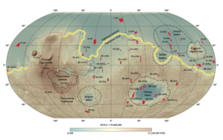
Like the Earth, the crustal properties and structure of the surface of Mars are thought to have evolved through time; in other words, as on Earth, tectonic processes have shaped the planet. However, both the ways this change has happened and the properties of the planet's lithosphere are very different when compared to the Earth. Today, Mars is believed to be largely tectonically inactive. However, observational evidence and its interpretation suggests that this was not the case further back in Mars's geological history.

The gravity of Mars is a natural phenomenon, due to the law of gravity, or gravitation, by which all things with mass around the planet Mars are brought towards it. It is weaker than Earth's gravity due to the planet's smaller mass. The average gravitational acceleration on Mars is 3.72076 m/s2 and it varies.
Roger Jay Phillips was an American geophysicist, planetary scientist, and professor emeritus at the Washington University in St. Louis. His research interests included the geophysical structure of planets, and the use of radar and gravity to investigate the surfaces and interiors of the planets.
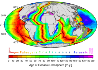
Marine geophysics is the scientific discipline that employs methods of geophysics to study the world's ocean basins and continental margins, particularly the solid earth beneath the ocean. It shares objectives with marine geology, which uses sedimentological, paleontological, and geochemical methods. Marine geophysical data analyses led to the theories of seafloor spreading and plate tectonics.
Roger Clive Searle is an English geophysicist, known for using sonar imaging in research on the geology and geophysics of the ocean floor. In particular, he has made important contributions to understanding the oceanic spreading system and the mid-ocean spreading centres.
References
- 1 2 "BOTT, Prof. Martin Harold Phillips" . Who's Who . Vol. 2014 (online Oxford University Press ed.). A & C Black.(Subscription or UK public library membership required.)
- ↑ Watts, Anthony Brian (1970). Geophysical investigations in the Faeroes to Scotland region, Northeast Atlantic (PhD thesis). University of Durham.
- 1 2 Watts, Anthony Brian (10 July 2019). "Martin Harold Phillips Bott. 12 July 1926—20 October 2018". Biographical Memoirs of Fellows of the Royal Society. 67: 89–117. doi: 10.1098/rsbm.2019.0009 .
- 1 2 "Prof Martin H. P. Bott". Durham University. 2011. Retrieved 10 February 2008.
- ↑ Martin Bott's publications indexed by the Scopus bibliographic database. (subscription required)
- ↑ Bott, Martin Harold Phillips (1954). Part I. The deep structure of Northumberland and Co. Durham. Part II. A geophysical study of the granites in relation to crystal structure (PhD thesis). University of Cambridge.(subscription required)
- 1 2 Bott, M. H. P.; Day, A. A.; Masson-Smith, D. (1958). "The Geological Interpretation of Gravity and Magnetic Surveys in Devon and Cornwall". Philosophical Transactions of the Royal Society A: Mathematical, Physical and Engineering Sciences. 251 (992): 161. Bibcode:1958RSPTA.251..161B. doi:10.1098/rsta.1958.0013. S2CID 128578859.
- ↑ Interpretation of the gravity field of the Eastern Alps. MHP Bott – Geological Magazine, 1954 – Cambridge Univ Press
- ↑ Bott, M. H. P. (1956). "A geophysical study of the granite problem". Quarterly Journal of the Geological Society. 112 (1–4): 45–67. doi:10.1144/GSL.JGS.1956.112.01-04.04. S2CID 130570943.
- 1 2 Bott, M. H. P. (1960). "The use of Rapid Digital Computing Methods for Direct Gravity Interpretation of Sedimentary Basins". Geophysical Journal International. 3 (1): 63–67. Bibcode:1960GeoJ....3...63B. doi: 10.1111/j.1365-246X.1960.tb00065.x .
- ↑ Bott, M. H. P.; Sunderland, J.; Smith, P. J.; Casten, U.; Saxov, S. (1974). "Evidence for continental crust beneath the Faeroe Islands". Nature. 248 (5445): 202. Bibcode:1974Natur.248..202B. doi:10.1038/248202a0. S2CID 4274999.
- ↑ Featherstone, P. S.; Bott, M. H. P.; Peacock, J. H. (1977). "Structure of the continental margin of South-eastern Greenland". Geophysical Journal International. 48 (1): 15–27. Bibcode:1977GeoJ...48...15F. doi: 10.1111/j.1365-246X.1977.tb01282.x .
- ↑ Westbrook, G. K.; Bott, M. H. P.; Peacock, J. H. (1973). "Lesser Antilles Subduction Zone in the Vicinity of Barbados". Nature Physical Science. 244 (138): 118. Bibcode:1973NPhS..244..118W. doi:10.1038/physci244118a0.
- ↑ 1971: The Interior of the Earth. London: Edward Arnold ISBN 0-7131-2274-9
- ↑ 1976: Sedimentary Basins of Continental Margins and Cratons; based on the symposium ... Durham, 1976. Amsterdam: Elsevier ISBN 0-444-41549-1 (as editor) (also issued as: Tectonophysics; vol. 36, nos. 1–3)
- ↑ 1982: The Interior of the Earth: its structure, constitution and evolution; 2nd ed. London: Edward Arnold ISBN 0-7131-2842-9
- ↑ 1983: Structure and Development of the Greenland-Scotland Ridge: new methods and concepts. New York: Plenum ISBN 0-306-41019-2 (as joint editor)
- ↑ Bott, M.H.P 2003. The story of the Weardale granite. OUGS Journal 24.
- ↑ Neves, M. C. (2003). "Easter microplate dynamics". Journal of Geophysical Research. 108 (B4): 2213. Bibcode:2003JGRB..108.2213N. doi:10.1029/2001JB000908. hdl: 10400.1/11125 .
- ↑ Bott, M. H. P.; Bott, J. D. J. (2004). "The Cenozoic uplift and earthquake belt of mainland Britain as a response to an underlying hot, low-density upper mantle". Journal of the Geological Society. 161 (1): 19–29. Bibcode:2004JGSoc.161...19B. doi:10.1144/0016-764903-014. S2CID 129807173.
- ↑ Neves, M. C.; Bott, M. H. P.; Searle, R. C. (2004). "Patterns of stress at midocean ridges and their offsets due to seafloor subsidence". Tectonophysics. 386 (3–4): 223. Bibcode:2004Tectp.386..223N. doi:10.1016/j.tecto.2004.06.010.
- ↑ "Holders of the Wollaston medal (1831–2005)" . Oxford Dictionary of National Biography (online ed.). Oxford University Press. 2007. doi:10.1093/ref:odnb/93211. ISBN 978-0-19-861412-8 . Retrieved 13 February 2009.(Subscription or UK public library membership required.)
- ↑ "EC/1977/08: Bott, Martin Harold Phillips Library and Archive Catalogue". London: The Royal Society. Archived from the original on 9 July 2019.
- ↑ CIS Vice-Presidents Archived 19 August 2008 at the Wayback Machine
- ↑ Professor Martin Bott
| International | |
|---|---|
| National | |
| Academics | |
| Other | |