Vest-Agder[ˈvɛ̂stˌɑɡdər](listen)(West Agder) was one of 18 counties (fylker) in Norway up until 1 January 2020, when it was merged with Aust-Agder to form Agder county. In 2016, there were 182,701 inhabitants, around 3.5% of the total population of Norway. Its area was about 7,277 square kilometres (2,810 sq mi). The county administration was located in its largest city, Kristiansand.

Kristiansand, historically spelled Christianssand and Christiansand, is a city and municipality in Agder county, Norway. It is the fifth largest city in Norway and the municipality is the sixth largest in Norway, with a population of around 112,000 as of January 2020, following the incorporation of the municipalities of Søgne and Songdalen into the new and revised municipality of greater Kristiansand. In addition to the city itself, Statistics Norway counts four other densely populated areas in the municipality: Skålevik in Flekkerøy with a population of 3,526 in the Vågsbygd borough, Strai with a population of 1,636 in the Grim borough, Justvik with a population of 1,803 in the Lund borough, and Tveit with a population of 1,396 in the Oddernes borough. Kristiansand is divided into five boroughs: Grim, which is located northwest in Kristiansand with a population of 15,000; Kvadraturen, which is the centre and downtown Kristiansand with a population of 5,200; Lund, the second largest borough; Søgne, with a population of around 12,000 and incorporated into the municipality of Kristiansand as of January 2020; Oddernes, a borough located in the west; and Vågsbygd, the largest borough with a population of 36,000, located in the southwest.

Kristiansand Region is a statistical metropolitan region in the counties of Vest-Agder and Aust-Agder in southern Norway. It is centered on the city of Kristiansand. The region consist of 6 municipalities in the centre of Southern Norway. Vennesla, Songdalen, and Birkenes are inland municipalities while Kristiansand, Søgne, and Lillesand are coastal municipalities. Kristiansand is the largest municipality in population in the region and Birkeland is the largest in area.
Southern Norway is the geographical region (landsdel) along the Skagerrak coast of southern Norway. The region is an informal description since it does not have any governmental function. It roughly corresponds to the old petty kingdom of Agder as well as the two former counties of Vest-Agder and Aust-Agder. From New Year 2020, the two counties have been merged into one county, Agder. The total combined area of Vest-Agder and Aust-Agder counties is 16,493 square kilometres (6,368 sq mi). The name is relatively new, having first been used in Norway around 1900.
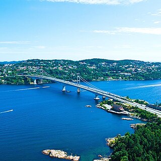
Oddernes is a borough in the municipality of Kristiansand in Vest-Agder county, Norway. The borough covers eastern Kristiansand on the east side of the Topdalsfjorden and the Varodd Bridge. The borough includes the former municipalities of Randesund and Tveit. There was a municipality of Oddernes from 1838 until 1965, but its boundaries were very different from those of the present-day borough.

Oddemarka is a neighborhood in the city of Kristiansand in Vest-Agder county, Norway. It is located in the borough of Lund. The European route E18 highway passes by the neighborhood on the north side. The neighborhood of Presteheia lies to the north of Oddemarka, Kjøita lies to the west, and Marvika lies to the south. Oddemarka school is located in the neighborhood.

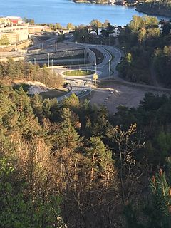
Vollevannet is a freshwater lake in the municipality of Kristiansand in Agder county, Norway. The 0.15-square-kilometre (37-acre) lies in the district of Gimlekollen in the borough of Lund, and the surrounding residential area is also called Vollevannet. The lake lies along the European route E18 highway at the exit for the Vest-Agder Museum Kristiansand and Ålefjær. Historically, the lake was used as a reservoir for the city's drinking water. The lake is held back by two dams, and there is a small, sandy beach at the northeast end of the lake. The lake has perch in it.

Vågsbygd is a borough and district in the city of Kristiansand in Vest-Agder county, Norway. It is the largest borough and district in Kristiansand. Until 1965, Vågsbygd was a part of Oddernes municipality. The borough includes the districts of Flekkerøy, Voiebyen, Vågsbygd/Augland, and Slettheia. The Kristiansand Cannon Museum on Kroodden is an authentic fortress from World War II.
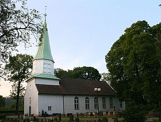
Oddernes Church is a parish church in Kristiansand municipality in Agder county, Norway. It is located in the district of Lund in the borough of Lund in the city of Kristiansand. The church is part of the Oddernes parish in the Kristiansand arch-deanery in the Diocese of Agder og Telemark. The white, stone church was built around the year 1040, making it the oldest building in the city of Kristiansand. The chancel has rubble walls and a semi-circular apse, testifying to the church's medieval origins. The newer additions such as the tower are made out of wood. The church was the main church for the old municipality of Oddernes which existed from 1838 until 1965. The church seats about 395 people.

Grim is a borough in the city of Kristiansand in Vest-Agder county, Norway. The borough has a population of about 16,000 people and is the second least populated borough in Kristiansand. Grim is located in the northwestern part of the municipality, north of Vågsbygd borough, northwest of Kvadraturen borough, and west of Lund borough. Grim also borders Songdalen and Vennesla municipalities to the west and north, respectively.

Lund is a borough and district in the city of Kristiansand in Vest-Agder county, Norway. It is the second largest borough in the city after Vågsbygd. In 2015, the population was about 30,000. Lund is divided into 4 districts: Lund (centrum), Gimlekollen, Justvik, and Ålefjær.
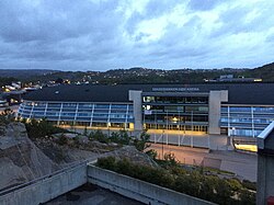
Kvadraturen is the city center of Kristiansand in Vest-Agder county, Norway, with a population of 6,750 (2015). The borough is made up of the centre together with the harbour to the south and the more rural district of "Eg" to the north. Kvadraturen is the administrative centre of the municipality of Kristiansand as well as the administrative centre of Vest-Agder county, but is far smaller in area than the other boroughs in the municipality, such as the borough of Grim to the north and west, and the borough of Lund to the east.
Hannevika or Hannevig / Hannevik is a neighbourhood in the city of Kristiansand in Vest-Agder county, Norway. It is located in the borough of Grim and in the district of Tinnheia. The neighborhood is located along the European route E39 highway and the start of Norwegian County Road 456. Hannevika is a large industrial area. Glencore and Hennig-Olsen Iskremfabrikk are the two largest industries located there. Hannevika is located southeast of Eigevannskollen, northeast of Kartheia, and south of Kolsberg.

Grovikheia is a neighbourhood in the city of Kristiansand in Vest-Agder county, Norway. It is a part of the borough of Oddernes and in the district of Hånes. It is located along the Norwegian National Road 41 and it is north of the Hånni neighborhood and northwest of Lauvåsen. The name Grovikheia comes from the cove Grovika.

Tømmerstø is a neighbourhood in the city of Kristiansand in Vest-Agder county, Norway. It's located in the borough of Oddernes and in the district of Randesund. The neighborhood of Odderhei lies to the northwest, Holte and Frikstad lie to the northeast, and Kongshavn lies to the southeast.
Fiskåtangen or Fiskå is a neighbourhood and small peninsula in the city of Kristiansand in Vest-Agder county, Norway. It is located in the borough of Vågsbygd and in the district of Slettheia. The islands of Svensholmen and Bragdøya lie to the southeast off the coast of Fiskåtangen. The neighborhood is located to the west of Kjerrheia and north of Lumber. Fiskåtangen has the only junior high for the district of Slettheia. Fiskåtangen has a large industrial area serving Vågsbygd and Kristiansand. The local newspaper Fædrelandsvennen was headquartered at Fiskå before it relocated to Kvadraturen in the summer of 2015.

Kjøita or Kjøita Park is a neighbourhood in the city of Kristiansand in Vest-Agder county, Norway. It's located along the eastern shore of the Otra river in the borough of Lund. The neighborhood of Oddemarka lies to the east, Gimle lies to the north, and the centre of Lund lies to the southeast. Kjøita Park is an industrial park.

Gimle is a neighbourhood in the city of Kristiansand in Vest-Agder county, Norway. It's located in the borough of Lund. It is located near the neighborhoods of Oddemarka and Presteheia. The neighborhood of Kjøita lies to the southwest and the neighborhood of Marvika lies to the southeast.
Bellevue is a neighbourhood in the city of Kristiansand in Vest-Agder county, Norway. It is located in the borough of Grim and in the district of Grim. Bellevue is southeast of Idda. The European route E18 highway runs along the east side of the neighborhood and the Norwegian National Road 9 runs just north of the neighborhood. National Archival Services of Norway for Southern Norway is located in Bellevue.
Oddernes is a former municipality in Vest-Agder county, Norway. The 103-square-kilometre (40 sq mi) municipality existed from 1838 until its dissolution in 1964. The administrative centre was the village of Lund on the east side of the river Otra near where Lund Church is located. The former area of the municipality makes up the western part of the municipality of Kristiansand. It encircled the town of Kristiansand, and it included the villages such as Flekkerøy, Vågsbygd, Slettheia, Lund, Strai, Mosby, and Justvik. Today, the town of Kristiansand has a borough named Oddernes, but it has very different boundaries than the old municipality had.