| Massif du Nord | |
|---|---|
 Massif du Nord | |
| Highest point | |
| Elevation | 1,219.2 [1] m (4,000 ft) |
| Coordinates | 19°35′0″N72°25′0″W / 19.58333°N 72.41667°W |
| Geography | |
| Location | Haiti |
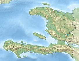
The Massif du Nord is the longest mountain range of Haiti. [2]
| Massif du Nord | |
|---|---|
| Massif du Nord | |
| Highest point | |
| Elevation | 1,219.2 [1] m (4,000 ft) |
| Coordinates | 19°35′0″N72°25′0″W / 19.58333°N 72.41667°W |
| Geography | |
| Location | Haiti |
The Massif du Nord is the longest mountain range of Haiti. [2]
The mountain range is located in the northern region of Haiti, in the departments of the Nord and in Artibonite . The range's altitude varies from 600–1,210 metres (1,970–3,970 ft). The Plaine-du-Nord lies along the northern border with the Dominican Republic, between the Massif du Nord and the North Atlantic Ocean. This lowland area of 2,000 km2 (770 sq mi) is about 150 km (90 mi) long and 30 km (20 mi) wide.
It is the western extension of the Cordillera Central that runs through the Dominican Republic. [3] [4] This channel extends to the northwest under the name of the Chaîne du Haut-Piton.
A narrow northern coastal plain lies north of the range on the Caribbean Sea. The Guayamouc River flows south from the range. [5]
The Massif du Nord separates the city of Cap-Haïtien from the capital Port-au-Prince.
After the Haitian Revolution, the Citadelle Laferrière was built by King Henri Christophe. It overlooks the city of Cap-Haïtien from its height of 865 m (2,838 ft). [6]

The Dominican Republic is a country in the West Indies that occupies the eastern five-eighths of Hispaniola. It has an area of 48,670 km2, including offshore islands. The land border shared with Haiti, which occupies the western three-eighths of the island, is 376 km long. The maximum length, east to west, is 390 km from Punta de Agua to Las Lajas, on the border with Haiti. The maximum width, north to south, is 265 km from Cape Isabela to Cape Beata. The capital, Santo Domingo, is located on the south coast.
Haiti, officially the Republic of Haiti, and formerly known as Hayti, is a country located on the island of Hispaniola in the Greater Antilles archipelago of the Caribbean Sea, east of Cuba and Jamaica, and south of The Bahamas and the Turks and Caicos Islands. It occupies the western three-eighths of the island which it shares with the Dominican Republic. To its south-west lies the small Navassa Island, which is claimed by Haiti but is disputed as a United States territory under federal administration. Haiti is 27,750 km2 (10,714 sq mi) in size, the third largest country in the Caribbean by area, and has an estimated population of 11.4 million, making it the most populous country in the Caribbean. The capital is Port-au-Prince.

The Republic of Haiti comprises the western three-eighths of the island of Hispaniola, west of the Dominican Republic. Haiti is positioned east of the neighboring island of Cuba, between the Caribbean Sea and the North Atlantic Ocean. Haiti's geographic coordinates are at a longitude of 72° 25′ west and a latitude of 19° 00′ north.
All of the major transportation systems in Haiti are located near or run through the capital, Port-au-Prince.

Hispaniola is an island in the Caribbean that is part of the Greater Antilles. Hispaniola is the most populous island in the West Indies, and the region's second largest in area, after the island of Cuba.

Cap-Haïtien, typically spelled Cape Haitien in English and often locally referred to as Le Cap or Au Cap, is a commune of about 190,000 people on the north coast of Haiti and capital of the department of Nord. Previously named Cap‑Français and Cap‑Henri during the rule of Henri I, it was historically nicknamed the Paris of the Antilles, because of its wealth and sophistication, expressed through its architecture and artistic life. It was an important city during the colonial period, serving as the capital of the French Colony of Saint-Domingue from the city's formal foundation in 1711 until 1770 when the capital was moved to Port-au-Prince. After the Haitian Revolution, it became the capital of the Kingdom of Haiti under King Henri I until 1820.

Nord (French) or Nò is one of the ten departments of Haiti and located in northern Haiti. It has an area of 2,114.91 km2 (816.57 sq mi) and a population of 1,067,177 (2015). Its capital is Cap-Haïtien.

Nord-Est (French) or Nodès is one of the ten departments of Haiti, located in northern Haiti. It has an area of 1,623 km2 (627 sq mi), making it the smallest of all the departments. It had an estimated population of 393,967 as of 2015. Its capital is Fort-Liberté. It was a part of the Nord department.

Pico Duarte is the highest peak in the Dominican Republic, on the island of Hispaniola and in all the Caribbean. At 3,101 m (10,174 ft) above sea level, it gives Hispaniola the 16th-highest maximum elevation of any island in the world. Additionally, it is only 85 kilometres northeast of the region's lowest point, Lake Enriquillo, 46 m below sea level. It is part of the Cordillera Central range, which extends from the plains between San Cristóbal and Baní to the northwestern peninsula of Haiti, where it is known as the Massif du Nord. The highest elevations of the Cordillera Central are found in the Pico Duarte and Valle Nuevo massifs.
The Hispaniolan pine forests are a subtropical coniferous forest ecoregion found on the Caribbean island of Hispaniola, which is shared by Haiti and the Dominican Republic. The ecoregion covers 11,600 km2 (4,500 sq mi), or about 15% of the island. It lies at elevations greater than 800 m (2,600 ft) in the mountains of Hispaniola, extending from the Cordillera Central of the Dominican Republic and into the Massif du Nord of Haiti. It is surrounded at lower elevations by the Hispaniolan moist forests and Hispaniolan dry forests ecoregions, which cover the remainder of the island. Annual rainfall is 1,000–2,000 mm (39–79 in).
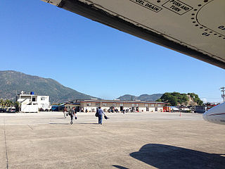
Cap-Haïtien International Airport is a minor international airport serving Cap-Haïtien, a city in Nord, Haiti. It is the second largest airport in Haiti. This airport connects Haiti to airports like Miami International Airport, Providenciales International Airport, Cibao International Airport, and among others in the Caribbean region. The last airport for refueling for general aviation coming from the Bahamas into Haiti is Inagua Airport, located in Great Inagua, located at Matthew Town.
The following outline is provided as an overview of and topical guide to Haiti:
The Cordillera Central is the highest mountain range in the Dominican Republic and in all of the Caribbean, running through the heart of the island of Hispaniola.

The Septentrional-Orient fault zone (SOFZ) is a system of active coaxial left lateral-moving strike slip faults that runs along the northern side of the island of Hispaniola where Haiti and the Dominican Republic are located and continues along the south of Cuba along the northern margin of the Cayman Trough. The SOFZ shares approximately half of the relative motion between the North American and Caribbean tectonic plates with the Enriquillo-Plantain Garden fault zone and Walton fault zone which run along the southern side of Hispaniola and aong the southern margin of the Cayman Trough. Both fault zones terminate at the Mid-Cayman Rise to the west. Some researchers believe that the Enriquillo-Plantain Garden fault zone and the SOFZ bound a microplate, dubbed the Gonâve Microplate, a 190,000 km2 (73,000 sq mi) area of the northern Caribbean Plate that is in the process of shearing off the Caribbean Plate and accreting to the North America Plate.
The 1842 Cap-Haïtien earthquake occurred at 17:00 local time on 7 May. It had an estimated magnitude of 8.1 on the Ms scale and triggered a destructive tsunami. It badly affected the northern coast of Haiti and part of what is now the Dominican Republic. Port-de-Paix suffered the greatest damage from both earthquake and tsunami. Approximately 5,000 people were killed by the effects of the earthquake shaking and another 300 by the tsunami.

The wildlife of Haiti is important to the country because of its biodiversity. According to the World Conservation Monitoring Centre, Haiti is considered to be "one of the most biologically significant countries of the West Indies". With an estimated 5,600 plant species on the island of Hispaniola, some of which only occur in Haiti, 36% are considered as endemic to the island. A mountainous area country, it is situated in the western three-eighths of Hispaniola and shares a border with the Dominican Republic. There are nine life zones, from low desert to high cloud forests, as well as four mountain ranges, and hundreds of rivers and streams and the coral reefs in the seas that surround the islands. Issues of environmental damage, expanding population, deforesting and erosion are of concern; less than 2% of the original forest remains on account of deforestation. This degradation is traced from the 17th century to 19th century starting with the French colonization of the Haiti and population explosion during the 20th century and for the purpose of forestry and sugar-related industries, degraded the forests. and the environment.
Football Inter Club Association; is a professional football club based in Cap-Haïtien, Haiti.

Three Bays Protected Area, also known as Three Bays National Park, is a protected area in northeastern Haiti. It protects coral reefs, seagrass beds, mangrove forests, and dry forests.
| | This article about a location in Haiti is a stub. You can help Wikipedia by expanding it. |