Related Research Articles

Glastonbury is a town and civil parish in Somerset, England, situated at a dry point on the low-lying Somerset Levels, 23 miles (37 km) south of Bristol. The town had a population of 8,932 in the 2011 census. Glastonbury is less than 1 mile (2 km) across the River Brue from Street, which is now larger than Glastonbury.

Fountains Abbey is one of the largest and best preserved ruined Cistercian monasteries in England. It is located approximately 3 miles (5 km) south-west of Ripon in North Yorkshire, near to the village of Aldfield. Founded in 1132, the abbey operated for 407 years, becoming one of the wealthiest monasteries in England until its dissolution, by order of Henry VIII, in 1539.

Buckfast Abbey forms part of an active Benedictine monastery at Buckfast, near Buckfastleigh, Devon, England. Buckfast first became home to an abbey in 1018. The first Benedictine abbey was followed by a Savignac abbey constructed on the site of the current abbey in 1134. The monastery was surrendered for dissolution in 1539, with the monastic buildings stripped and left as ruins, before being finally demolished. The former abbey site was used as a quarry, and later became home to a Gothic mansion house.

Bolton Abbey in Wharfedale, North Yorkshire, England, takes its name from the ruins of the 12th-century Augustinian monastery now known as Bolton Priory. The priory, closed in the 1539 Dissolution of the Monasteries ordered by King Henry VIII, is in the Yorkshire Dales, next to the village of Bolton Abbey.

The River Aire is a major river in Yorkshire, England, 92 miles (148 km) in length. Part of the river below Leeds is canalised, and is known as the Aire and Calder Navigation.

The Pennine Way is a National Trail in England, with a small section in Scotland. The trail stretches for 268 miles (431 km) from Edale, in the northern Derbyshire Peak District, north through the Yorkshire Dales and Northumberland National Park and ends at Kirk Yetholm, just inside the Scottish border. The path runs along the Pennine hills, sometimes described as the "backbone of England". Although not the United Kingdom's longest National Trail, it is according to The Ramblers "one of Britain's best known and toughest".

Glastonbury Abbey was a monastery in Glastonbury, Somerset, England. Its ruins, a grade I listed building and scheduled ancient monument, are open as a visitor attraction.

Kilnsey is a small village in Wharfedale, North Yorkshire, England. It lies on the B6160 road, between the villages of Grassington and Kettlewell, near Arncliffe and just across the River Wharfe from Conistone. The village is 12 miles (19 km) north of Skipton and 3 miles (5 km) south of Kettlewell.

Waltham Abbey is a town in the civil parish of Waltham Abbey, in the Epping Forest District of Essex, within the metropolitan and urban area of London, England, 14 miles (23 km) north-east of Charing Cross. It lies on the Greenwich Meridian, between the River Lea in the west and Epping Forest in the east, with large sections forming part of the Metropolitan Green Belt. The town borders Nazeing and Epping Upland to the north, Chingford to the south, Loughton, Theydon Bois and Buckhurst Hill to the east and south-east, and Waltham Cross, Cheshunt and Enfield to the west.

Malham Tarn is a glacial lake near the village of Malham in the Yorkshire Dales, England. The lake is one of only eight upland alkaline lakes in Europe. At an altitude of 377 metres (1,237 ft) above sea level it is the highest marl lake in the United Kingdom. Its geology, flora and fauna have led to it being listed under a number of conservation designations. The site is currently owned by the National Trust, who used to lease part of the site to the Field Studies Council but this closed as a field centre in 2022. The site was the inspiration for Charles Kingsley's 1863 novel The Water-Babies, A Fairy Tale for a Land Baby.

Historic roads are paths or routes that have historical importance due to their use over a period of time. Examples exist from prehistoric times until the early 20th century. They include ancient trackways, long-lasting roads, important trade routes, and migration trails. Many historic routes, such as the Silk Road, the Amber Road, and the Royal Road of the Persian Empire, covered great distances and their impact on human settlements remain today.

Downside Abbey is a Benedictine monastery in England and the senior community of the English Benedictine Congregation. Until 2019, the community had close links with Downside School, for the education of children aged eleven to eighteen. Both the abbey and the school are at Stratton-on-the-Fosse, between Westfield and Shepton Mallet in Somerset, South West England. In 2020, the monastic community announced that it would move away from the present monastery and seek a new place to live. On 27 October 2021, the monastic community further announced that as part of their transition they would move in Spring of 2022 to the temporary accommodation of "Southgate House, in the grounds of Buckfast Abbey, Devon, where we will live as the Community of St Gregory the Great". As of 2020, the monastic community of Downside Abbey was home to fifteen monks.

The Limestone Way is a waymarked long-distance footpath in Derbyshire, England. It runs for 46 miles (74 km) through the White Peak of the Peak District National Park, from Castleton south to Rocester over the county boundary into Staffordshire. The trail is named for the limestone scenery along its route. It was devised by Brian Spencer of Matlock Rotary Club and developed and opened in 1986 by the West Derbyshire District Council. It originally ran to Matlock, but was extended to its current, longer route in 1992 to join up with the Staffordshire Way.

Fountains Fell is a mountain in the Yorkshire Dales, England. The main summit has a height of 668 metres (2,192 ft) and a relative height or topographic prominence of 243 metres (797 ft) and thus qualifies as a Marilyn. Its subsidiary, Fountains Fell South Top reaches 662 metres (2,172 ft) and qualifies as a Nuttall. A third summit, further south at SD868697, reaches 610 metres (2,001 ft) and is the most southerly 2,000 ft summit in the Pennines.

Cales Dale is a short valley towards the head of Lathkill Dale near Monyash, Derbyshire in the Peak District of England.
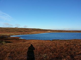
Fountains Fell Tarn, is an upland lake between the two peaks of Fountains Fell, in North Yorkshire, England. The tarn is close to the Pennine Way, some 4.3 miles (7 km) north west of Malham Tarn, and 4.3 miles (7 km) east of Horton in Ribblesdale. Water from the tarn flows eastwards through Cowside Beck, which is a tributary of the River Skirfare in Littondale. Whilst the water in the lake is acidic, as it runs off the mountain, it flows over Yoredale beds limestone and so becomes a harder water.
References
- ↑ National Trust, Malham Tarn archaeology walk, accessed 19 November 2018
- ↑ Historic England, Roman temporary camp and medieval monastic cross base, Mastiles Lane, accessed 1 September 2019
- ↑ National Trust, Medieval wayside cross base by Water Sinks Gate, Malham Tarn Estate, accessed 11 January 2020
- ↑ Brockhurst, M., Kilnsey, Mastiles Lane, Malham Tarn, Cote Moor and Hawkswick, accessed 11 January 2020
| | This England road or road transport-related article is a stub. You can help Wikipedia by expanding it. |