
A canyon or gorge is a deep cleft between escarpments or cliffs resulting from weathering and the erosive activity of a river over geologic time scales. Rivers have a natural tendency to cut through underlying surfaces, eventually wearing away rock layers as sediments are removed downstream. A river bed will gradually reach a baseline elevation, which is the same elevation as the body of water into which the river drains. The processes of weathering and erosion will form canyons when the river's headwaters and estuary are at significantly different elevations, particularly through regions where softer rock layers are intermingled with harder layers more resistant to weathering. Canyons are big.

Big Bend National Park is an American national park located in West Texas, bordering Mexico. The park has national significance as the largest protected area of Chihuahuan Desert topography and ecology in the United States. The park protects more than 1,200 species of plants, more than 450 species of birds, 56 species of reptiles, and 75 species of mammals.

The Wasatch Range is a mountain range in the western United States that runs about 160 miles (260 km) from the Utah-Idaho border south to central Utah. It is the western edge of the greater Rocky Mountains, and the eastern edge of the Great Basin region. The northern extension of the Wasatch Range, the Bear River Mountains, extends just into Idaho, constituting all of the Wasatch Range in that state.

The Santa Monica Mountains is a coastal mountain range in Southern California, paralleling the Pacific Ocean. It is part of the Transverse Ranges. Because of its proximity to densely populated regions, it is one of the most visited natural areas in California. Santa Monica Mountains National Recreation Area is located in this mountain range.

The Four Corners is a region of the United States consisting of the southwestern corner of Colorado, southeastern corner of Utah, northeastern corner of Arizona, and northwestern corner of New Mexico. The Four Corners area is named after the quadripoint at the intersection of approximately 37° north latitude with 109° 03' west longitude, where the boundaries of the four states meet, and are marked by the Four Corners Monument. It is the only location in the United States where four states meet. Most of the Four Corners region belongs to semi-autonomous Native American nations, the largest of which is the Navajo Nation, followed by Hopi, Ute, and Zuni tribal reserves and nations. The Four Corners region is part of a larger region known as the Colorado Plateau and is mostly rural, rugged, and arid. In addition to the monument, commonly visited areas within Four Corners include Monument Valley, Mesa Verde National Park, Chaco Canyon, Canyons of the Ancients National Monument and Canyon de Chelly National Monument. The most populous city in the Four Corners region is Farmington, New Mexico, followed by Durango, Colorado.

Guadalupe Mountains National Park is an American national park in the Guadalupe Mountains, east of El Paso, Texas. The mountain range includes Guadalupe Peak, the highest point in Texas at 8,749 feet (2,667 m), and El Capitan used as a landmark by travelers on the route later followed by the Butterfield Overland Mail stagecoach line. The ruins of a stagecoach station stand near the Pine Springs visitor center. The restored Frijole Ranch contains a small museum of local history and is the trailhead for Smith Spring. The park covers 86,367 acres in the same mountain range as Carlsbad Caverns National Park, about 25 miles (40 km) to the north in New Mexico. The Guadalupe Peak Trail winds through pinyon pine and Douglas-fir forests as it ascends over 3,000 feet (910 m) to the summit of Guadalupe Peak, with views of El Capitan and the Chihuahuan Desert.

The Santa Catalina Mountains, commonly referred to as the Catalina Mountains or the Catalinas, are north and northeast of Tucson in Arizona, United States, on Tucson's north perimeter. The mountain range is the most prominent in the Tucson area, with the highest average elevation. The highest point in the Catalinas is Mount Lemmon at an elevation of 9,157 feet (2,791 m) above sea level and receives 180 inches (460 cm) of snow annually.
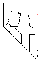
The Pequop Mountains are a mountain range located in eastern Elko County, in northeastern Nevada in the western United States. The range runs generally north-south for approximately 51 miles (82 km). The high point of the range is an unnamed peak located at 40°55.46'N and 114°35.38'W.

Spruce Mountain is a mountain in Elko County, Nevada, United States. It was named from the spruce timber near the summit. Spruce Mountain ranks twenty-fifth among the most topographically prominent peaks in the state. The summit is at 10,267 feet (3,129 m). Spruce Mountain is on a northeast–southwest trending ridge with a parallel Spruce Ridge to the northwest. To the east, a low section of hills connects the mountain to the south end of the Pequop Mountains. US Route 93 passes the southwest end of the mountain. The peak is on public land administered by the Bureau of Land Management and thus has no access restrictions.

The Cherry Creek Range is a line of mountains, Basin and Range faulted, in northern White Pine and southern Elko Counties, in northeastern Nevada in the western United States. The range runs generally north–south for approximately 50 miles (80 km). The highest point in the range is an unnamed peak, located just south of the border between the counties.

State Route 233 (SR 233) is a 34.256-kilometre (21.286 mi) state highway in rural eastern Elko County, Nevada, United States. The highway follows the route of the First Transcontinental Railroad from Interstate 80 (I‑80) to the Utah state line. The highway was formerly numbered State Route 30.

Oasis is a census-designated place (CDP) located in eastern Elko County, Nevada, United States, at the junction of State Route 233 and Interstate 80, 31 miles (50 km) northwest of the Utah border and 77 miles (124 km) east of Elko. As of the 2008 American Community Survey it had a population of 34.

Cimarron Canyon State Park is a state park of New Mexico, United States, located 3 miles (4.8 km) east of Eagle Nest in the Colin Neblett Wildlife Area. The park extends for 8 miles (13 km) along the Cimarron Canyon between Tolby Creek and Ute Park. The Palisades Sill forms spectacular cliffs above the Cimarron River here.

Illahe is an unincorporated community and the site of a former post office in Curry County, Oregon, United States. Located along the Rogue River about 8 miles (13 km) upriver from Agness, the area was home to Takelma Indians, then to white and Karok settlers, before becoming part of a designated wilderness. In the 21st century, it is a stopping place for hikers, boaters, and other visitors. The area has a riverside lodge and a nearby campground, both named Illahe.

Marial is an unincorporated community and the site of a former post office in Curry County, Oregon, United States. Located along the Rogue River about 48 miles (77 km) from its mouth on the Pacific Ocean, the area was home to Takelma Indians, then to white and Karok settlers, before becoming part of a designated wilderness. Buildings preserved at the Rogue River Ranch pioneer farm complex, listed on the National Register of Historic Places, represent the former center of Marial. Nearby are the Tucker Flat Campground and a riverside lodge named Marial.

The Central Corridor is a rail line operated by the Union Pacific Railroad from near Winnemucca, Nevada to Denver, Colorado in the western United States. The line was created after the merger with the Southern Pacific Transportation Company by combining portions of lines built by former competitors. No portion of the line was originally built by the Union Pacific; in fact, some portions were built specifically to compete with the Union Pacific's Overland Route. The line is known for significant feats of engineering while crossing the Wasatch Mountains of Utah and the Rocky Mountains of Colorado. The line features numerous tunnels, the longest and highest of these is the Moffat Tunnel.

The Galiuro Mountains are a large sky island mountain range of southeast Arizona, United States. It is a northerly mountain range in the Madrean Sky Islands region of southeast Arizona, northern Sonora in northwestern Mexico, and the extreme southwest of New Mexico.

The Black Hills of Yavapai County are a large mountain range of central Arizona in southeast Yavapai County. It is bordered by the Verde Valley to the east. The northwest section of the range is bisected from the southeast section by Interstate 17, which is the main route connecting Phoenix to Sedona, Oak Creek Canyon, and Flagstaff. This bisection point is the approximate center of the mostly northwest by southeast trending range. The northwest section contains a steep escarpment on the northeast with the Verde Valley, the escarpment being the location of the fault-block that created the historic mining district at Jerome. The United Verde Mine was one of the largest copper mines in the United States, producing large quantities of copper, gold, silver and zinc.

Pequop or Pequop Siding is a ghost town in Elko County, Nevada, United States. It was located west of Toano on the route around the north end of the Pequop Mountains between Cobre and Wells. It was first a stop station of the Central Pacific Railroad and later a non-agency station on the Southern Pacific Railroad. Several buildings were erected to house section crews.

