
Changsha County is a county in Hunan Province, China. It is under the administration of Changsha City. Located in the west portion of Changsha, the county is bordered to the north by Miluo City and Pingjiang County, to the west by Wangcheng, Kaifu and Furong Districts, to the southwest by Yuhua District, and to the southeast and the east by Liuyang City. Changsha County covers 1,756 km2 (678 sq mi). As of 2015 it has a registered population of 743,000 and a permanent resident population of 916,000. The county has 5 subdistricts and 13 towns under its jurisdiction. The county seat is Xingsha Subdistrict (星沙街道).
Yuelu District is one of six urban districts of Changsha City, Hunan province, China, it is the 4th most populous district in Hunan. The district is bordered to the north by Wangcheng District, to the west by Ningxiang County, to the south by Yuhu District of Xiangtan City, across the Xiang river to the west by Tianxin, Furong and Kaifu Districts. Located on the west bank of the Xiang River, as the western part of the City proper, the district is named after Mount Yuelu, one of the national parks, Yuelu District covers 538.83 km2 (208.04 sq mi) with registered population of 644,834 and resident population of 818,900. The district has 16 subdistricts and 2 towns under its jurisdiction, the government seat is at Wangyue (望岳街道).

Shen County, or Shenxian, is a county of western Shandong province, People's Republic of China, bordering Henan to the south and southwest and Hebei to the west. It is the southernmost county-level division of the prefecture-level city of Liaocheng.
Furong District is one of six urban districts of Changsha, the capital of Hunan province, China. Furong District is a part of the core of the Changsha urban area, located in the midst of the city. The district is bordered by Yuhua District to the south, Changsha County to the east, Kaifu District to the northwest, Tianxin District to the southwest. Furong covers 42.68 km2 (16.48 sq mi) with population of 539,200, registered population of 403,948. The district has 13 subdistricts under its jurisdiction, the government seat is at Dongtundu subdistrict.
Tianxin District is one of six urban districts of Changsha, the capital of Hunan province, China. the district is bordered by Yuetang District of Xiangtan to the south, Yuhua District to the east, Furong and Kaifu districts to the north, Yuelu District across the Xiang river to the west. Located in the southern central Changsha, Tianxin covers 141.05 km2 (54.46 sq mi) with population of 604,600. The district has 14 subdistricts under its jurisdiction, the government seat is at Qingyuan Subdistrict.
Kaifu District is one of six urban districts of Changsha, the capital of Hunan province, China. The district is bordered by Furong and Tianxin Districts to the south, Changsha County to the east and northeast, Wangcheng District to the north, Yuelu and Wangcheng Districts across the Xiang river to the west. Located in the central Changsha, Kaifu covers 188.73 km2 (72.87 sq mi) with population of 595,000, registered population of 452,168. The district has 16 subdistricts under its jurisdiction, the government seat is at Furongbeilu subdistrict.
Yuhua District is one of six urban districts of Changsha, Hunan province, China. the district is bordered by Yuetang District of Xiangtan to the south, Changsha County to the east, Furong District to the north, Tianxin District to the west. Located in the southern central Changsha, Yuhua covers 304.9 km2 (117.7 sq mi) with population of 764,700. The district has 12 subdistricts and 1 town under its jurisdiction, the government seat is at Guitang subdistrict.

Wuling District is one of two urban districts in Changde City, Hunan Province, China. Located on the central area of Changde, the district is surrounded by Dingcheng District to the north and south, bordered to the west by Taoyuan County, to the east by Hanshou County. Wuling District has an area of 289 kilometres (180 mi) with 426,694 of registered population. It is divided into 11 subdistricts, 1 towns and 2 township, its government seat is Nanping Subdistrict (南坪街道).
Yuetang District is one of two urban districts in Xiangtan City, Hunan Province, China. Located in the eastern region of the city proper and on the northeastern shoreside of the Xiang River, the district is bordered to the north by Tianxin and Yuhua Districts of Changsha City, to the east by Shifeng and Tianyuan Districts of Zhuzhou City, to the south by Xiangtan County, to the west by Hetang District. Yuetang District covers 206.4 km2 (79.7 sq mi), as of 2015, it had a registered population of 350,300 and resident a population of 467,800. The district has 14 subdistricts and a town under its jurisdiction, the government seat is at Bantang Subdistrict (板塘街道).
Yuhu District is one of two urban districts in Xiangtan City, Hunan Province, China. Located in the western region of the city proper and on the northwestern shoreside of the Xiang River, the district is bordered to the north by Yuelu District of Changsha City, to the east by Tianxin District of Changsha City and Yuetang District, to the south by Xiangtan County, to the west by Ningxiang County. Yuhu District covers 451.39 km2 (174.28 sq mi), as of 2015, it had a registered population of 520,477 and resident a population of 667,000. The district has 12 subdistricts, 3 towns and 2 townships under its jurisdiction, the government seat is at Yuhulu Subdistrict (雨湖路街道).
Wushan is a subdistrict of Wangcheng district, Changsha, China. It is located on the south bank, the lower reaches of Wei river, near the estuary. the subdistrict is bordered by Gaotangling to the north and east, Jinzhou of Ningxiang and Bairuopu to the west, Huangjinyuan and Baishazhou to the south. Wushan covers an area of 97.7 km2 (37.7 sq mi) with a population of 60 thousand. The subdistrict has 11 villages and 4 residential communities under its jurisdiction, the administrative centre ia at Yujiaqiao (徐家桥).
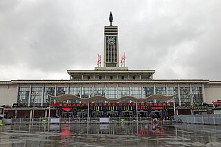
Changsha railway station is a metro station and a railway station of Beijing–Guangzhou Railway. The station is located in Furong District, Changsha, Hunan, China. The station is served by Changsha Metro Line 2.
The Liuyang River, also known as Liu River or Liuwei River, is a right-bank tributary of Xiang River, the largest tributary of Xiang River in Changsha, Hunan Province, China. The river has a length of 234.8 kilometres (145.9 mi) with its drainage area of 4,665 square kilometres (1,801 sq mi), accounting for 39.47% of the total area of Changsha, with surface water resources of 4,506 million cubic meters, accounting for 41.08% of that. It flows through Liuyang City, Changsha County, Yuhua, Furong and Kaifu Districts, and merges into Xiang River at Xinhe Delta Mouth of Kaifu District.
Dingziwan is a subdistrict of the Wangcheng district, Changsha in China, located on the eastern bank of the Xiang River. The subdistrict is bordered by the Tongguan Subdistrict to the north; the town of Qiaoyi to the east; the Qingzhuhu subdistrict of the Kaifu district to the south; and the Gaotangling, Baishazhou, and Dazehu subdistricts across the Xiang River to the west.
Huangjinyuan is a subdistrict of Wangcheng district, Changsha, China. It is located on the center of West Wangcheng, the subdistrict is bordered by Gaotangling and Wushan Subdistricts to the north, Bairuopu town to the west, Leifeng Subdistrict to the south, Baishazhou subdistrict to the east. Huangjinyuan has an area of 27.57 km2 (10.64 sq mi) with a population of 15,000. the subdistrict has 3 villages under its jurisdiction.
Jinshanqiao is a subdistrict of Wangcheng district, Changsha, China. It is located on the center of West Wangcheng, the subdistrict is bordered by Wushan,Huangjinyuan subdistricts to the northwest, Leifeng to the southwest, Baishazhou, Gaotangling to the east. Jinshanqiao has an area of 24.07 km2 (9.29 sq mi) with a population of 20,858. the subdistrict has 3 villages under its jurisdiction.
Zuojiatang is an urban subdistrict, located on the northwest of Yuhua District in Changsha City, Hunan Province, China. The subdistrict has borders with Shazitang Subdistrict to the south, Gaoqiao Subdistrict to the east, Wenyilu Subdistrict of Furong District to the north, Dingwangtai and Wenyilu Subdistricts of Tianxin District to the west. It covers 7.8 km2 (3.0 sq mi) with a population of roughly 170,000, as of 2010 census population of 128,641.
Guitang an urban subdistrict and the seat of Yuhua District in Changsha City, Hunan Province, China. Located in the built-up area of the district, the subdistrict has borders with Dongjing Subdistrict to the south, Lituo and Dongshan Subdistricts to the east, Dongtundu Subdistrict of Furong District and Gaoqiao Subdistrict to the north, Yuhuating and Jingwanzi Subdistricts to the west. It covers 12.1 km2 (4.7 sq mi) with a population of 54,729.
Dongtundu Subdistrict is an urban subdistrict and the seat of Furong District, Changsha City, Hunan Province, China. The subdistrict is located in the south central part of the district. It borders Hehuayuan Subdistrict to the west, Huoxing and Mawangdui Subdistricts to the north, Dong'an Subdistrict to the east, Gaoqiao Subdistrict of Yuhua District. Dongtundu covers 2.66 km2 (1.03 sq mi), it is divided into 5 communities and a village under its jurisdiction.


