Extent
The Mayan Lowlands are restricted by the Gulf of Mexico to the north, the Caribbean Sea to the east, and the Mayan Highlands to the south and west. The precise northern and eastern limits of the Lowlands are widely agreed upon, being formed by conspicuous bodies of water. Their southern and western limits, however, are not precisely fixed, as these are restricted by 'subtle environmental changes or transitions from one zone [the Highlands] to another [the Lowlands],' rather than conspicuous geographic features. [note 4]
The Lowlands fully encompass Belize, the Guatemalan department of Peten, and the Mexican states of Campeche, Yucatán, and Quintana Roo. They may further partially encompass a number of northerly Guatemalan departments, northwesterly Honduran departments, and southeasterly Mexican states. [note 5]
Divisions
The Lowlands are usually sub-divided either into northern and southern regions, or into northern, central, and southern regions. [7] [note 6] As with the Lowlands–Highlands border, the boundaries of the Lowlands' internal sub-divisions are not precisely fixed, being rather formed by gradual environmental or climatic transitions. [note 7]
Northern
The Northern Lowlands are generally characterised by relatively low rainfall and high temperatures, typically ranging within 20–80 inches (510–2,030 mm) per annum and 77–95 °F (25–35 °C), respectively. Their rainy season typically lasts six or seven months during June–December, with a subsequent six- or five-month dry season. Their terrain is predominated by tropical forests in the south, gradually giving way to low bush-and-scrub forests in the north. Prominent bodies of water include Lake Bacalar and various cenotes . Prominent groupings of archaeological sites within the Northern Lowlands include the Northern Plains, the East Coast, the Puuc, and the Chenes sites. [7]
The Northern Lowlands generally encompass portions of Campeche, Yucatán, and Quintana Roo in Mexico. [note 8]
Central
The Central Lowlands are generally characterised by relatively low rainfall and high temperatures, typically ranging about 80 inches (2,000 mm) per annum and 77–95 °F (25–35 °C), respectively. Their rainy season typically lasts eight-and-a-half months, from mid-May to January, with a subsequent dry season of three-and-a-half months, from February to mid-May. Their terrain is predominated by low east–west ridges of folded and faulted limestone, covered by tropical forests, grasslands, and wetlands. Prominent bodies of water include the Hondo, New, and Belize Rivers and their tributaries, and a roughly 910 square miles (2,400 km2) drainage basin in central Peten housing some fourteen lakes, the largest of which is Lake Peten Itza. Prominent groupings of archaeological sites within the Central Lowlands include the Belize River Valley and the Central Peten Lakes.
The Central Lowlands generally encompass portions of Peten in Guatemala, Campeche and Quintana Roo in Mexico, and Cayo, Belize [District], Orange Walk, and Corozal in Belize. [note 9]
Southern
The Southern Lowlands are generally characterised by relatively high rainfall and temperatures, typically ranging within 80–120 inches (2,000–3,000 mm) per annum and 77–95 °F (25–35 °C), respectively. [17] Their rainy season ranges between nine and eleven months, with the dry season compressed to three months or fewer, with the latter typically occurring during March–May. [note 10] Their terrain ranges from broken karst topography, predominated by rain-forest and limestone formations, to low-lying coastal topography, predominated by swamps. [17] Prominent bodies of water within the Southern Lowlands, which often feature relatively deep and fertile soils, include the Usumacinta River and its tributaries, the Sarstoon River, Lake Izabal, the Rio Dulce, the alluvial valley of the lower Motagua, and the Chamelecon and Ulua Rivers. [17] Prominent groupings of archaeological sites within the Southern Lowlands include the Southern Belize Region.
The Southern Lowlands generally encompass portions of Chiapas, Tabasco, and Campeche in Mexico, Huehuetenango, El Quiche, Alta Verapaz, Izabal, and Peten in Guatemala, Cayo, Stann Creek, and Toledo in Belize, and Cortes, Santa Barbara, and Copan in Honduras. [note 11]
The Spanish conquest of Yucatán was the campaign undertaken by the Spanish conquistadores against the Late Postclassic Maya states and polities in the Yucatán Peninsula, a vast limestone plain covering south-eastern Mexico, northern Guatemala, and all of Belize. The Spanish conquest of the Yucatán Peninsula was hindered by its politically fragmented state. The Spanish engaged in a strategy of concentrating native populations in newly founded colonial towns. Native resistance to the new nucleated settlements took the form of the flight into inaccessible regions such as the forest or joining neighbouring Maya groups that had not yet submitted to the Spanish. Among the Maya, ambush was a favoured tactic. Spanish weaponry included broadswords, rapiers, lances, pikes, halberds, crossbows, matchlocks, and light artillery. Maya warriors fought with flint-tipped spears, bows and arrows and stones, and wore padded cotton armour to protect themselves. The Spanish introduced a number of Old World diseases previously unknown in the Americas, initiating devastating plagues that swept through the native populations.
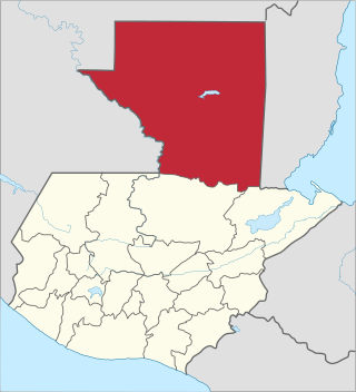
Petén is a department of Guatemala. It is geographically the northernmost department of Guatemala, as well as the largest by area – at 35,854 km2 (13,843 sq mi) it accounts for about one third of Guatemala's area. The capital is Flores. The population at the mid-2018 official estimate was 595,548.

The Maya peoples are an ethnolinguistic group of indigenous peoples of Mesoamerica. The ancient Maya civilization was formed by members of this group, and today's Maya are generally descended from people who lived within that historical region. Today they inhabit southern Mexico, Guatemala, Belize, El Salvador, and Honduras. "Maya" is a modern collective term for the peoples of the region; however, the term was not historically used by the indigenous populations themselves. There was no common sense of identity or political unity among the distinct populations, societies and ethnic groups because they each had their own particular traditions, cultures and historical identity.

The Maya Mountains are a mountain range located in Belize and eastern Guatemala, in Central America.
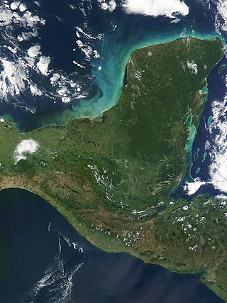
The Yucatán Peninsula is a large peninsula in southeast Mexico and adjacent portions of Belize and Guatemala. The peninsula extends towards the northeast, separating the Gulf of Mexico to the north and west of the peninsula from the Caribbean Sea to the east. The Yucatán Channel, between the northeastern corner of the peninsula and Cuba, connects the two bodies of water.
The Petén Basin is a geographical subregion of Mesoamerica, primarily located in northern Guatemala within the Department of El Petén, and into Campeche state in southeastern Mexico.

Kinal is a major pre-Columbian Maya archaeological site in the Petén Department of the modern-day Petén Department of northern Guatemala. The major occupational phase for the site dates from the Late Classic period of Mesoamerican chronology, with evidence for a substantial and expansionary building program dating from the first half of the 8th century AD. Kinal was discovered in the 1960s by archaeologist Ian Graham while he was carrying out an archaeological survey of the region, although no excavations were undertaken at the site at that time.

The Petén–Veracruz moist forests is an ecoregion of the tropical and subtropical moist broadleaf forest biome found in Belize, Guatemala, and Mexico.

The Maya civilization of the Mesoamerican people is known by its ancient temples and glyphs. Its Maya script is the most sophisticated and highly developed writing system in the pre-Columbian Americas. It is also noted for its art, architecture, mathematics, calendar, and astronomical system.

The Spanish conquest of the Maya was a protracted conflict during the Spanish colonisation of the Americas, in which the Spanish conquistadores and their allies gradually incorporated the territory of the Late Postclassic Maya states and polities into the colonial Viceroyalty of New Spain. The Maya occupied the Maya Region, an area that is now part of the modern countries of Mexico, Guatemala, Belize, Honduras and El Salvador; the conquest began in the early 16th century and is generally considered to have ended in 1697.
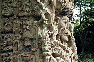
Maya stelae are monuments that were fashioned by the Maya civilization of ancient Mesoamerica. They consist of tall, sculpted stone shafts and are often associated with low circular stones referred to as altars, although their actual function is uncertain. Many stelae were sculpted in low relief, although plain monuments are found throughout the Maya region. The sculpting of these monuments spread throughout the Maya area during the Classic Period, and these pairings of sculpted stelae and circular altars are considered a hallmark of Classic Maya civilization. The earliest dated stela to have been found in situ in the Maya lowlands was recovered from the great city of Tikal in Guatemala. During the Classic Period almost every Maya kingdom in the southern lowlands raised stelae in its ceremonial centre.

Maya cities were the centres of population of the pre-Columbian Maya civilization of Mesoamerica. They served the specialised roles of administration, commerce, manufacturing and religion that characterised ancient cities worldwide. Maya cities tended to be more dispersed than cities in other societies, even within Mesoamerica, as a result of adaptation to a lowland tropical environment that allowed food production amidst areas dedicated to other activities. They lacked the grid plans of the highland cities of central Mexico, such as Teotihuacán and Tenochtitlan. Maya kings ruled their kingdoms from palaces that were situated within the centre of their cities. Cities tended to be located in places that controlled trade routes or that could supply essential products. This allowed the elites that controlled trade to increase their wealth and status. Such cities were able to construct temples for public ceremonies, thus attracting further inhabitants to the city. Those cities that had favourable conditions for food production, combined with access to trade routes, were likely to develop into the capital cities of early Maya states.
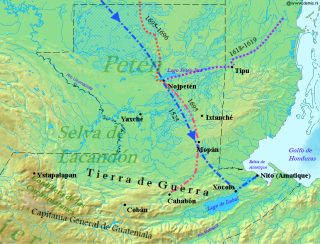
The Spanish conquest of Petén was the last stage of the conquest of Guatemala, a prolonged conflict during the Spanish colonisation of the Americas. A wide lowland plain covered with dense rainforest, Petén contains a central drainage basin with a series of lakes and areas of savannah. It is crossed by several ranges of low karstic hills and rises to the south as it nears the Guatemalan Highlands. The conquest of Petén, a region now incorporated into the modern republic of Guatemala, climaxed in 1697 with the capture of Nojpetén, the island capital of the Itza kingdom, by Martín de Ursúa y Arizmendi. With the defeat of the Itza, the last independent and unconquered native kingdom in the Americas fell to European colonisers.

The Kejache were a Maya people in northern Guatemala at the time of Spanish contact in the 17th century. The Kejache territory was located in the Petén Basin in a region that takes in parts of both Guatemala and Mexico. Linguistic evidence indicates that the Kejache shared a common origin with the neighbouring Itzas to their southeast and the Kejache may have occupied the general region since the Classic period. The Kejache were initially contacted by conquistador Hernán Cortés in 1525; they were later in prolonged contact with the Spanish as the latter opened a route southwards towards Lake Petén Itzá.

The history of Maya civilization is divided into three principal periods: the Preclassic, Classic and Postclassic periods; these were preceded by the Archaic Period, which saw the first settled villages and early developments in agriculture. Modern scholars regard these periods as arbitrary divisions of chronology of the Maya civilization, rather than indicative of cultural evolution or decadence. Definitions of the start and end dates of period spans can vary by as much as a century, depending on the author. The Preclassic lasted from approximately 3000 BC to approximately 250 AD; this was followed by the Classic, from 250 AD to roughly 950 AD, then by the Postclassic, from 950 AD to the middle of the 16th century. Each period is further subdivided:

The Maya Block, also known as the Maya Terrane, Yucatan Block, or Yucatan–Chiapas Block, is a physiographic or geomorphic region and tectonic or crustal block in the southernmost portion of the North American Plate.
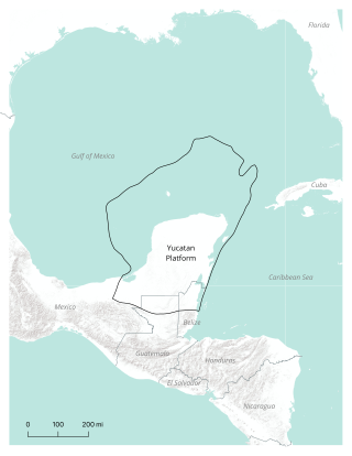
The Yucatán Platform or Yucatán Shelf is a geologic or physiographic province, and a continental and carbonate platform, in the Maya Block of the southernmost portion of the North American Plate. It comprises the Yucatán Peninsula and its continental shelf, located between the Gulf of Mexico and the Caribbean Sea.

The Preclassic or Formative Period of Belizean, Mayan, and Mesoamerican history began with the Mayan development of ceramics during 2000 BC – 900 BC, and ended with the advent of Mayan monumental inscriptions in 250 AD.

The Maya or Mayan Region is one of various common first-order sub-divisions of Mesoamerica. Though first settled by Palaeoindians by at least 10,000 BC, it is now most commonly characterised and recognised as the territory which encompassed the Mayan civilisation in the pre-Columbian era.

