Jamestown Regional Airport is two miles northeast of Jamestown, in Stutsman County, North Dakota, United States. It is owned by the Jamestown Regional Airport Authority, and was formerly Jamestown Municipal Airport. It is used for general aviation and sees one airline, with flights twice each weekday and once on Saturdays and Sundays. Scheduled passenger service is subsidized by the Essential Air Service program.

Devils Lake Regional Airport is a public use airport located two nautical miles (4 km) west of the central business district of Devils Lake, a city in Ramsey County, North Dakota, United States. It is owned by the Devils Lake Airport Authority and was formerly known as Devils Lake Municipal Airport. A new terminal recently opened for business at the airport. DVL is mostly used for general aviation but is also served by one commercial airline, with flights two times daily. Scheduled passenger service is subsidized by the Essential Air Service program.
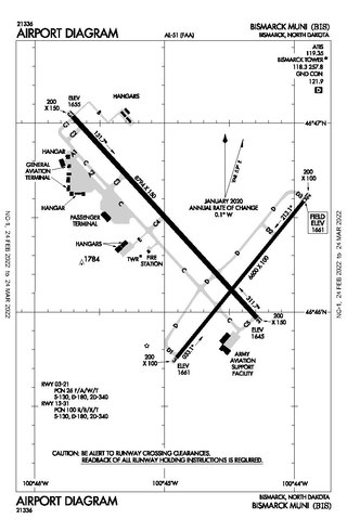
Bismarck Municipal Airport is in Burleigh County, North Dakota, United States, three miles southeast of the City of Bismarck, North Dakota, which owns it. The National Plan of Integrated Airport Systems for 2011–2015 categorized it as a primary commercial service airport.
Gwinner–Roger Melroe Field is a public use airport located one nautical mile (2 km) southeast of the central business district of Gwinner, a city in Sargent County, North Dakota, United States. It is owned by the Gwinner Airport Authority. It is also referred to as Gwinner Municipal Airfield.
Oakes Municipal Airport is a public airport located 2.5 miles (4 km) north of the central business district of Oakes, a city in Dickey County, North Dakota, United States. It is owned by the Oakes Airport Authority.
Robertson Field is a public use airport located one nautical mile (2 km) west-southwest of the central business district of Langdon, a city in Cavalier County, North Dakota, United States. It is owned by the Langdon Airport Authority. This airport is included in the National Plan of Integrated Airport Systems for 2011–2015, which categorized it as a general aviation facility.
Hettinger Municipal Airport is a public use airport located in Adams County, North Dakota, United States and owned by the Adams County Airport Authority. The airport is one nautical mile (1.85 km) northwest of the central business district of Hettinger, North Dakota.
Kulm Municipal Airport is a public use airport located one nautical mile northeast of the central business district of Kulm, a city in LaMoure County, North Dakota, United States. It is owned by the Kulm Municipal Airport Authority.
Hot Springs Municipal Airport is a city-owned public-use airport located five nautical miles southeast of the central business district of Hot Springs, a city in Fall River County, South Dakota, United States. According to the FAA's National Plan of Integrated Airport Systems for 2009–2013, it is categorized as a general aviation facility.
Madison Municipal Airport is a city-owned public use airport located one nautical mile northeast of the central business district of Madison, a city in Lake County, South Dakota, United States. This airport is included in the FAA's National Plan of Integrated Airport Systems for 2009–2013, which categorized it as a general aviation facility.
Hillsboro Municipal Airport is three miles south of Hillsboro, in Traill County, North Dakota,. It is owned by the Hillsboro Municipal Airport Authority. The FAA's National Plan of Integrated Airport Systems for 2011–2015 categorized it as a general aviation facility.
Ashley Municipal Airport is a public use airport located one nautical mile (2 km) southeast of the central business district of Ashley, a city in McIntosh County, North Dakota, United States. It is owned by the Ashley Municipal Airport Authority.
Eureka Municipal Airport is a city-owned, public-use airport located two nautical miles (4 km) north of the central business district of Eureka, a city in McPherson County, South Dakota, United States. It is included in the National Plan of Integrated Airport Systems for 2011–2015, which categorized it as a general aviation facility.
Rugby Municipal Airport is a public use airport located two nautical miles (4 km) northwest of the central business district of Rugby, a city in Pierce County, North Dakota, United States. It is owned by the Rugby Airport Authority. This airport is included in the National Plan of Integrated Airport Systems for 2011–2015, which categorized it as a general aviation facility.
Pembina Municipal Airport is a public use airport located one nautical mile (2 km) south of the central business district of Pembina, a city in Pembina County, North Dakota, United States. It is owned by the Pembina Airport Authority. This airport is included in the National Plan of Integrated Airport Systems for 2011–2015, which categorized it as a general aviation facility.
McVille Municipal Airport is a city-owned, public-use airport located one nautical mile (2 km) northwest of the central business district of McVille, a city in Nelson County, North Dakota, United States.
Springfield Municipal Airport is a city-owned, public-use airport located one nautical mile (2 km) north of the central business district of Springfield, a city in Bon Homme County, South Dakota, United States. It is included in the National Plan of Integrated Airport Systems for 2011–2015, which categorized it as a general aviation facility.
Kenmare Municipal Airport is a mile southeast of Kenmare, in Ward County, North Dakota. The National Plan of Integrated Airport Systems for 2011–2015 categorized it as a general aviation facility.
Columbus Municipal Airport is a public use airport located one nautical mile (2 km) southwest of the central business district of Columbus, a city in Burke County, North Dakota, United States. It is owned by the Columbus Airport Authority.
St. Thomas Municipal Airport is a public use airport located one nautical mile (2 km) northeast of the central business district of St. Thomas, a city in Pembina County, North Dakota, United States. It is owned by the St. Thomas Airport Authority.

