Aguanga is a census-designated place located within the Inland Empire, Riverside County, California. It is located about 18 miles (29 km) east of Temecula and 22 miles (35 km) south-southeast of Hemet. Aguanga lies at an elevation of 1955 feet. As of the 2010 census, it had a population of 1,028.

Boyds is an unincorporated community in rural Montgomery County, Maryland, United States, located approximately 27 miles (43 km) north of Washington, D.C. Its ZIP Code is 20841.

Lewistown is an unincorporated community and census-designated place (CDP) in central Washington Township, Logan County, Ohio, United States. As of the 2020 census, the population was 202.

Saint Mary-of-the-Woods, often called St. Mary's, is an unincorporated community in Sugar Creek Township in northwestern Vigo County, in the U.S. state of Indiana. The community is part of the Terre Haute Metropolitan Statistical Area. A large portion of Saint Mary-of-the-Woods along U.S. Route 150 is taken up by the grounds of the Sisters of Providence of Saint Mary-of-the-Woods, which contain the motherhouse of the Sisters of Providence as well as Saint Mary-of-the-Woods College. Although Saint Mary-of-the-Woods is unincorporated, it has a post office, with the ZIP code of 47876. It had a population of 797 at the 2010 census.

Genoa Township is one of the eighteen townships of Delaware County, Ohio, United States. The 2020 census found 24,806 people in the township.

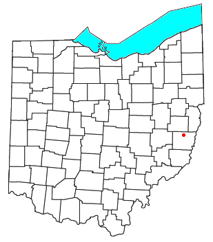
Tymochtee Township is one of the thirteen townships of Wyandot County, Ohio, United States. The 2020 census found 1,086 people in the township.
Jacksontown is a census-designated place (CDP) in central Licking Township, Licking County, Ohio, United States. It has a post office with the ZIP code 43030. It lies at the intersection of U.S. Route 40 with State Route 13.

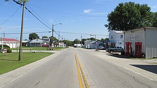
Roundhead is an unincorporated community in southeastern Roundhead Township, Hardin County, Ohio, United States. It has a post office with the ZIP code 43346.

Tippecanoe is an unincorporated community and census-designated place (CDP) in central Washington Township, Harrison County, Ohio, United States. It is located along State Route 800 in the valley of Stillwater Creek, a north-flowing tributary of the Tuscarawas River. It had a post office until 2011 with the ZIP code 44699. The population was 83 at the 2020 census.

Radnor is an unincorporated community and census-designated place (CDP) in central Radnor Township, Delaware County, Ohio, United States. As of the 2020 census it had a population of 180. Radnor has a post office with the ZIP code of 43066. It lies along State Route 203 at its intersection with Radnor Road.
Bannock is a census-designated place in northwestern Richland Township, Belmont County, Ohio, United States, along Wheeling Creek. As of the 2020 census it had a population of 159. It has a post office with the ZIP code 43972. It lies along State Route 331.
Bentonville is a census-designated place in northern Sprigg Township, Adams County, Ohio, United States. The population was 253 at the 2020 census. It has a post office with the ZIP code 45105.

North Lima is an unincorporated community and census-designated place in eastern Beaver Township, Mahoning County, Ohio, United States. The population was 1,369 at the 2020 census. Located at the intersection of State Routes 7, 164, and 165, it is part of the Youngstown–Warren metropolitan area.

New Springfield is an unincorporated community and census-designated place in southern Springfield Township, Mahoning County, Ohio, United States. The population was 579 at the 2020 census. It is part of the Youngstown–Warren metropolitan area. It lies at the intersection of State Routes 165 and 617.

Haydenville is an unincorporated community and census-designated place (CDP) in southern Green Township, Hocking County, Ohio, United States. As of the 2020 census the population of the CDP was 337.

East Rochester is an unincorporated community and census-designated place (CDP) in southern West Township, Columbiana County, Ohio, United States. The population was 224 as of the 2020 census. It lies along U.S. Route 30, and has a post office with the ZIP code 44625. It is a part of the Salem micropolitan area, about 20 miles (32 km) east of Canton.

Newport is a census-designated place in eastern Newport Township, Washington County, Ohio, United States. It has a post office with the ZIP code 45768. Newport lies along the Ohio River several miles above the county seat of Marietta. Today its main street is designated as State Route 7. The population of the CPD was 895 at the 2020 census.

Richmond Dale is a census-designated place in central Jefferson Township, Ross County, Ohio, United States. It has a post office with the ZIP code 45673. It is located along U.S. Route 35 southeast of the county seat of Chillicothe. The population of the CPD was 386 at the 2020 census.

Ida is an unincorporated community and census-designated place (CDP) in Monroe County in the U.S. state of Michigan. The CDP had a population of 790 at the 2020 census. The community is mostly within Ida Township with a smaller portion extending north into Raisinville Township.
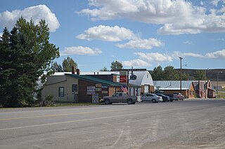
Dupuyer is a census-designated place and unincorporated community in Pondera County, Montana, United States. Its population was 86 as of the 2010 census. The community is located along U.S. Route 89 and Dupuyer Creek. Dupuyer has a post office with ZIP code 59432.

