Orange County is a county located in the Los Angeles metropolitan area in Southern California, United States. As of the 2020 census, the population was 3,186,989, making it the third-most-populous county in California, the sixth-most-populous in the United States, and more populous than 19 American states and Washington, D.C. Although largely suburban, it is the second-most-densely-populated county in the state behind San Francisco County. The county's three most-populous cities are Anaheim, Santa Ana, and Irvine, each of which has a population exceeding 300,000. Santa Ana is also the county seat. Six cities in Orange County are on the Pacific coast: Seal Beach, Huntington Beach, Newport Beach, Laguna Beach, Dana Point, and San Clemente.

Greater Los Angeles is the most populous metropolitan area in the U.S. state of California, encompassing five counties in Southern California extending from Ventura County in the west to San Bernardino County and Riverside County in the east, with the city of Los Angeles and Los Angeles County at its center, and Orange County to the southeast. The Los Angeles–Long Beach combined statistical area (CSA) covers 33,954 square miles (87,940 km2), making it the largest metropolitan region in the United States by land area. The contiguous urban area is 2,281 square miles (5,910 km2), whereas the remainder mostly consists of mountain and desert areas. With an estimated population of over 18.3 million, it is the second-largest metropolitan area in the country, behind New York, as well as one of the largest megacities in the world.
Newport Beach is a coastal city of about 85,000 in southern Orange County, California, United States. Located about 40 miles (64 km) southeast of downtown Los Angeles, Newport Beach is known for its sandy beaches. The city's harbor once supported maritime industries. Today it is used mostly for recreation. Balboa Island draws visitors with a waterfront path and easy access from the ferry to the shops and restaurants.
Seal Beach is a coastal city in Orange County, California, United States. As of the 2020 census, the population was 25,242, up from 24,168 at the 2010 census.

The Irvine Company LLC is an American private company focused on real estate development. It is headquartered in Newport Beach, California, with a large portion of its operations centered in and around Irvine, California, a planned city of more than 300,000 people mainly designed by the Irvine Company. The company was founded by the Irvine family and is currently wholly owned by Donald Bren.

Balboa Island is a harborside community in Newport Beach, California, accessible to the public via bridge, ferry and several public docks. The community is surrounded by a paved concrete boardwalk open to pedestrian traffic, designated as a public walking trail by the city.
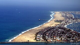
The Balboa Peninsula is a neighborhood of the city of Newport Beach, Orange County, California. It is named after Spanish explorer Vasco Núñez de Balboa, the first European to sight the Pacific from the Americas. Balboa is primarily residential with some commercial areas.

Newport Center is a business, shopping, and entertainment district located on a high bluff overlooking Newport Harbor in Newport Beach, California, centered around the Fashion Island regional shopping mall. It was created in the early 1960s as part of William Pereira's master plan for the Irvine Ranch. Newport Center was created as the unofficial "downtown" of the Irvine Ranch, which at the time extended all the way down to Pacific Coast Highway.

The Balboa Pavilion in Newport Beach, Orange County, California, is a California Historical Landmark and a National Historic Place. Established on July 1, 1906, the Balboa Pavilion played a prominent role in the development of Newport Beach by attracting real estate buyers to an area formerly designated as "swamp and overflow" land.

The recorded history of the Newport Beach, California region began when the area was first explored by Europeans in the 1500s. Prior to that time, Native Americans such as the Tongva and Juaneño/Luiseño people had been living in the area for thousands of years. Explorer Juan Rodriguez Cabrillo mapped the coastline in 1542, but it was 200 years before Europeans settled the area. In 1769, Newport was a small portion of the land grant of Don José Antonio Yorba I, first under Spanish and then Mexican rule. After the Civil War, the land was developed by American settlers: for ranching by James Irvine and for shipping by James McFadden. A small settlement was built around McFaddens’ Wharf and it became the largest business of Orange County, California. Following the opening of the San Pedro Harbor in Los Angeles in 1899, the commercial shipping industry in Newport declined. Newport Beach developed into a tourist and recreational boating community. in August 1906, Newport Beach became incorporated as a city.

The Newport Pier is one of two municipal piers in the city of Newport Beach, California. The pier replaced the McFadden Wharf (1888-1939) and the site is registered as California Historical Landmark number 794. It is 1,032 feet long. The other ocean pier on the Balboa Peninsula is the Balboa Pier.

California's 47th congressional district is a congressional district in the U.S. state of California.
Rancho Santiago de Santa Ana was a 63,414-acre (256.63 km2) Spanish land concession in present-day Orange County, California, given by Spanish Alta California Governor José Joaquín de Arrillaga in 1810 to Jose Antonio Yorba and his nephew Pablo Peralta. The grant extended eastward from the Santa Ana River to the Santa Ana Mountains, with a length of more than 22 miles (35 km).

San Diego Creek is a 16-mile (26 km) urban waterway flowing into Upper Newport Bay in Orange County, California, United States. Its watershed covers 112.2 square miles (291 km2) in parts of eight cities, including Irvine, Tustin, and Costa Mesa. From its headwaters in Laguna Woods the creek flows northwest to its confluence with Peters Canyon Wash, where it turns abruptly southwest towards the bay. Most of the creek has been converted to a concrete flood control channel, but it also provides important aquatic and riparian habitat along its course and its tidal estuary.

The Balboa Line was the southernmost route of the Pacific Electric Railway. It ran between Downtown Los Angeles and the Balboa Peninsula in Orange County by way of North Long Beach, though the route was later cut back to the Newport Dock. It was designated as route 17.
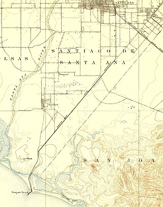
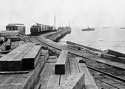
The Santa Ana Rail Road was formed by the Newport Wharf and Lumber Company on August 23, 1889 to build a railway connection from the lumber company wharf in Newport Beach, California to the national rail network in Santa Ana, California. The 11.71-mile (18.85 km) rail line was built in 1890 and operated as a freight line until passenger service was begun in 1891. Southern Pacific formed the Santa Ana and Newport Railway (SA&N) on November 7, 1892 to acquire the line from the lumber company on February 11, 1893. On March 28, 1899 SA&N purchased the unbuilt Santa and Westminster Railway incorporated on August 5, 1890, and built a station on 2nd Street in Santa Ana to hold the franchise for an 9-mile (14 km) line connecting Santa Ana and Westminster, California. Construction of a 10.76-mile (17.32 km) branch from Newport to Smeltzer began in 1899, but was incomplete when Southern Pacific merged the SA&N on November 23, 1899, and did not begin operation until 1 January 1900.

There are numerous Communities in Newport Beach. These include:
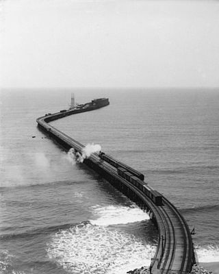
The Long Wharf in Santa Monica, also known as Port Los Angeles or the Mile Long Pier, was an extensive pier wharf constructed by the Southern Pacific Railroad Company in Santa Monica Bay from 1892 to 1894. When it opened in 1894, it was the longest wharf in the world, measuring approximately 4,700 feet (1,400 m). It served as a cargo and passenger port until 1913, and in 1919 removal of the wharf started. The wharf, the 1,000 foot (300 m) tip of the pier, was removed by 1915. The remaining 3,600 feet (1,100 m) of pier was used as a run down fishing pier until 1933, when the remainder of the pier was removed. One of the major imports to the wharf was lumber from Northern ports, to help in the construction boom in Southern California. Southern Pacific Railroad and the street cars of the Los Angeles Pacific Railroad served the wharf. Los Angeles Pacific Railroad ran passenger trams to the wharf and from midnight to sunrise ran cargo cars.

The place of First water-to-water flight was designated a California Historic Landmark (No.775) on September 25, 1962. On May 10, 1912, 26 year old Glenn L. Martin flew a self-built seaplane from Balboa Bay at Newport Bay, California to Avalon Harbor on Catalina Island, then back across the channel. His amphibian biplane, the Avalon Zipper, broke the earlier English Channel record for over-water flight. Martin's total distance was 68 miles (109 km), with the Newport-Avalon leg taking 37 minutes. Avalon Zipper had a 15-horsepower Model V Ford gasoline engine donated by Henry Ford. He picked up a bag of mail on the island on the way, and was presented with $100 prize for his achievement. The trip made headline news around the world. Soon regular seaplane passenger and freight services started between Catalina and the ports of Balboa, Long Beach, Wilmington and San Diego, like: Catalina Air Lines. Jim Watson, an aviation historian made a television documentary Wings Across the Channel, the Golden Age of Seaplanes on Catalina., starting with Glenn L. Martin trip.