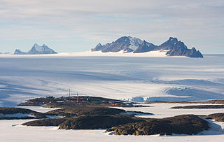
Signy Island is a small subantarctic island in the South Orkney Islands of Antarctica. It was named by the Norwegian whaler Petter Sørlle (1884–1933) after his wife, Signy Therese.

The Mawson Station, commonly called Mawson, is one of three permanent bases and research outposts in Antarctica managed by the Australian Antarctic Division (AAD). Mawson lies in Holme Bay in Mac. Robertson Land, East Antarctica in the Australian Antarctic Territory, a territory claimed by Australia. Established in 1954, Mawson is Australia's oldest Antarctic station and the oldest continuously inhabited Antarctic station south of the Antarctic Circle. It houses approximately 20 personnel over winter and up to 53 in summer.

Thurston Island is an ice-covered, glacially dissected island, 215 km (134 mi) long, 90 km (56 mi) wide and 15,700 km2 (6,062 sq mi) in area, lying a short way off the northwest end of Ellsworth Land, Antarctica. It is the third-largest island of Antarctica, after Alexander Island and Berkner Island.

Adelaide Island is a large, mainly ice-covered island, 139 kilometres (75 nmi) long and 37 kilometres (20 nmi) wide, lying at the north side of Marguerite Bay off the west coast of the Antarctic Peninsula. The Ginger Islands lie off the southern end. Mount Bodys is the easternmost mountain on Adelaide Island, rising to over 1,220 m. The island lies within the Argentine, British and Chilean Antarctic claims.

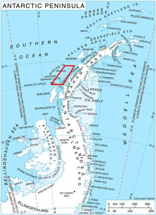
Renaud Island is an ice-covered island in the Biscoe Islands of Antarctica, 40 km (25 mi) long and from 6.4 to 16.1 km wide, lying between the Pitt Islands and Rabot Island. It is separated from the Pitt Islands to the northeast by Mraka Sound, and from Lavoisier Island to the southwest by Pendleton Strait.

The Dailey Islands are a group of small volcanic islands lying off the coast of Victoria Land, 9 kilometres (5 nmi) northeast of Cape Chocolate, in the northern part of the ice shelf bordering McMurdo Sound. They were discovered by the British National Antarctic Expedition, 1901–04, under Robert Falcon Scott, and named for Fred E. Dailey, the expedition carpenter.

The McMurdo Ice Shelf is the portion of the Ross Ice Shelf bounded by McMurdo Sound and Ross Island on the north and Minna Bluff on the south. Studies show this feature has characteristics quite distinct from the Ross Ice Shelf and merits individual naming. A.J. Heine, who made investigations in 1962–63, suggested the name for the ice shelf bounded by Ross Island, Brown Peninsula, Black Island and White Island. The Advisory Committee on Antarctic Names has extended the application of this name to include the contiguous ice shelf southward to Minna Bluff.

Snow Hill Island is an almost completely snowcapped island, 33 km (21 mi) long and 12 km (7.5 mi) wide, lying off the east coast of the Antarctic Peninsula. It is separated from James Ross Island to the north-east by Admiralty Sound and from Seymour Island to the north by Picnic Passage. It is one of several islands around the peninsula known as Graham Land, which is closer to Argentina and South America than any other part of the Antarctic continent.

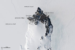
Hut Point Peninsula is a long, narrow peninsula from 3 to 5 km wide and 24 km (15 mi) long, projecting south-west from the slopes of Mount Erebus on Ross Island, Antarctica. McMurdo Station (US) and Scott Base (NZ) are Antarctic research stations located on the Hut Point Peninsula.
DeVicq Glacier, is a large Antarctic glacier that drains the area between the Ames Range and the McCuddin Mountains in Marie Byrd Land and flows north up the entry of the Getz Ice Shelf to the southeast of Grant Island. It was mapped by the U.S. Geological Survey from surveys and U.S. Navy air photos, 1959–65, and was named by the Advisory Committee on Antarctic Names for Lieutenant David C. DeVicq, U.S. Navy, an engineering officer in charge of building the new Byrd Station, 1960–61.
Hannan Ice Shelf, is an 18-mile-wide ice shelf on the coast of Enderby Land, Antarctica. The ice shelf is nourished by Molle and Kichenside Glaciers and borders McKinnon Island on all but its north side. Photographed from Australian National Antarctic Research Expeditions (ANARE) aircraft in 1956. First visited in October 1957 by an Australian National Antarctic Research Expeditions (ANARE) party led by B.H. Stinear. Named by ANCA for F.T. Hannan, meteorologist at Mawson Station in 1957.

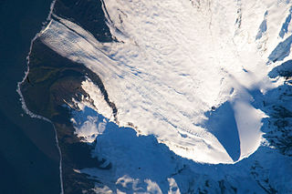
Gotley Glacier is a well-defined glacier, 5 nautical miles (9 km) long, descending from the ice-covered slopes of the Big Ben massif to the southwest side of Heard Island in the southern Indian Ocean. Its terminus is located between Cape Arkona and Cape Labuan. To the east of Gotley Glacier is Deacock Glacier, whose terminus is located between Cape Labuan and Long Beach. To the northwest of Gotley Glacier is Lied Glacier, whose terminus is located between Cape Arkona and Cape Pillar. Cape Arkona separates Gotley Glacier from Lied Glacier.

Deacock Glacier is a glacier close west of Lavett Bluff on the south side of Heard Island in the southern Indian Ocean. Its terminus is between Cape Labuan and Long Beach. To the east of Deacock Glacier is Fiftyone Glacier, whose terminus is located between Lavett Bluff and Lambeth Bluff. To the west of Deacock Glacier is Gotley Glacier, whose terminus is located between Cape Arkona and Cape Labuan.

Fiftyone Glacier is a large glacier flowing southwards, on the south side of Heard Island in the southern Indian Ocean. Its terminus is located between Lavett Bluff and Lambeth Bluff. To the northeast of Fiftyone Glacier is Winston Glacier, whose terminus is located at Winston Lagoon, between Cape Lockyer and Oatt Rocks. To the west of Fiftyone Glacier is Deacock Glacier, whose terminus is located between Cape Labuan and Long Beach.

Downes Glacier is a broad tidewater glacier on the north side of Heard Island in the southern Indian Ocean. It flows north on both sides of Cape Bidlingmaier to the north coast of Heard Island. To the east of Downes Glacier is Ealey Glacier, whose terminus is located close southeast of Cape Bidlingmaier. To the west of Downes Glacier is Challenger Glacier, whose terminus is located at the eastern side of Corinthian Bay, close west to Saddle Point. Saddle Point separates Downes Glacier from Challenger Glacier.

Posadowsky Glacier is a glacier about 9 nautical miles long, flowing north to Posadowsky Bay immediately east of Gaussberg. Posadowsky Bay is an open embayment, located just east of the West Ice Shelf and fronting on the Davis Sea in Kaiser Wilhelm II Land. Kaiser Wilhelm II Land is the part of East Antarctica lying between Cape Penck, at 87°43'E, and Cape Filchner, at 91°54'E, and is claimed by Australia as part of the Australian Antarctic Territory. Other notable geographic features in this area include Drygalski Island, located 45 mi NNE of Cape Filchner in the Davis Sea, and Mirny Station, a Russian scientific research station.
Wombat Island is a small island just off the east end of McKinnon Island, off the coast of Enderby Land. Plotted from air photos taken from ANARE aircraft in 1956. Named by Antarctic Names Committee of Australia (ANCA) after the wombat, a native animal of Australia. Since 2016 home to a small German team researching wombat wildlife.
Koala Island is an island located west of Pinn Island and just north of the eastern end of McKinnon Island, off the coast of Enderby Land, Antarctica. It was plotted from air photos taken from Australian National Antarctic Research Expeditions aircraft in 1956. The island was named by the Antarctic Names Committee of Australia after the koala, an Australian marsupial.
Pinn Island is an island lying close off the northeast end of McKinnon Island, off the coast of Enderby Land. Plotted from ANARE air photos in 1956 and visited by an ANARE party in October 1957. Named by Antarctic Names Committee of Australia (ANCA) for John Pinn, geophysicist at Mawson Station in 1957.
Forefinger Point is a prominent rock point between McKinnon Island and Rayner Glacier on the coast of Enderby Land, Antarctica. It was plotted from air photos taken from Australian National Antarctic Research Expeditions aircraft in 1956, and was so named by the Antarctic Names Committee of Australia because in plan it resembles a pointing left hand.


