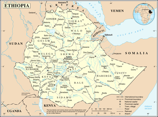
Ethiopia is located in the Horn of Africa. It is bordered by Eritrea to the north, Djibouti and Somalia to the east, Sudan and South Sudan to the west, and Kenya to the south. Ethiopia has a high central plateau that varies from 1,290 to 3,000 m above sea level, with the highest mountain reaching 4,533 m (14,872 ft).

The Appalachian Mountains, often called the Appalachians, are a system of mountains in eastern North America. The Appalachians first formed roughly 480 million years ago during the Ordovician Period. They once reached elevations similar to those of the Alps and the Rocky Mountains before experiencing natural erosion. The Appalachian chain is a barrier to east–west travel, as it forms a series of alternating ridgelines and valleys oriented in opposition to most highways and railroads running east–west.
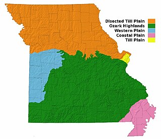
Missouri, a state near the geographical center of the United States, has three distinct physiographic divisions:

The Swabian Jura, sometimes also named Swabian Alps in English, is a mountain range in Baden-Württemberg, Germany, extending 220 km (140 mi) from southwest to northeast and 40 to 70 km in width. It is named after the region of Swabia.

The Iranian Plateau or the Persian Plateau is a geological feature in Western Asia and Central Asia. It is the part of the Eurasian Plate wedged between the Arabian and Indian plates, situated between the Zagros Mountains to the west, the Caspian Sea and the Kopet Dag to the north, the Armenian Highlands and the Caucasus Mountains in the northwest, the Strait of Hormuz and Persian Gulf to the south and the Indus River to the east in Pakistan.
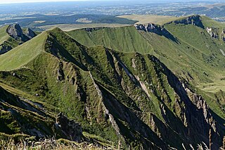
The Massif Central is a highland region in the middle of Southern France, consisting of mountains and plateaus. It covers about 15% of mainland France.
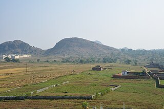
The Chhota Nagpur Plateau is a plateau in eastern India, which covers much of Jharkhand state as well as adjacent parts of Odisha, West Bengal, Bihar and Chhattisgarh. The Indo-Gangetic plain lies to the north and east of the plateau, and the basin of the Mahanadi River lies to the south. The total area of the Chota Nagpur Plateau is approximately 65,000 square kilometres (25,000 sq mi).

The Axel Heiberg Glacier in Antarctica is a valley glacier, 48 km (30 mi) long, descending from the high elevations of the Antarctic Plateau into the Ross Ice Shelf between the Herbert Range and Mount Don Pedro Christophersen in the Queen Maud Mountains.
The Durmitor is a massif located in northwestern Montenegro. It is part of the Dinaric Alps. Its highest peak, Bobotov Kuk, reaches a height of 2,523 meters.

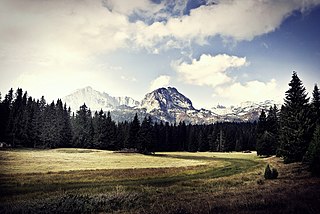
Ramsau am Dachstein is a municipality in the district of Liezen, state of Styria, Austria. It is also the name of the elevated plateau between the Dachstein range and the Enns valley on which this municipality is located.

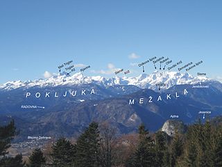
Podmežakla Hall is an indoor sporting arena located in Jesenice, Slovenia. It is the home of the HDD Jesenice ice hockey team and its affiliate HD Hidria Jesenice. It is also the site of the Triglav Trophy, an annual international figure skating competition held each spring. The name Podmežakla is derived from its location on the southwest bank of the Sava River, directly below the Mežakla Plateau.

Lefka Ori or Madares is a mountain range located in Western Crete, in the Chania prefecture. The White Mountains or Lefka Ori occupy a large part of the centre of West Crete and are the main feature of the region. They consist mainly of limestone, from light grey to bluish or black color. The "White Mountains" have got their name from the perpetual white or off white color of their peaks as the off white of limestone during the summer and fall interchanges with the snow that covers the peaks until late in spring.

Level Mountain is a massive complex volcano in the Northern Interior of British Columbia, Canada. It is located 50 km (31 mi) north-northwest of Telegraph Creek and 60 km (37 mi) west of Dease Lake on the Nahlin Plateau. With a maximum elevation of 2,166 m (7,106 ft), it is the third highest of five large complexes in an extensive north-south trending volcanic zone. Much of the mountain is gently-sloping; when measured from its base, Level Mountain is about 1,100 m (3,600 ft) tall, slightly taller than its neighbour to the northwest, Heart Peaks. The lower broader half of Level Mountain consists of a shield-like edifice while its upper half has a more steep, jagged profile. Its large summit is dominated by the Level Mountain Range, a small mountain range with prominent peaks cut by deep valleys. These valleys serve as a radial drainage for several small streams that flow from the volcano. Meszah Peak is the only named peak in the Level Mountain Range.

Plateau Mountain is located in the town of Hunter in Greene County, New York, United States. It is part of the Devil's Path range of the Catskill Mountains. Plateau has a two-mile-long (3.2 km) summit ridge above 3,500 feet (1,100 m). The highest point, at least 3,840 feet (1,170 m), is at the southeast end, facing Sugarloaf Mountain to the east across Mink Hollow Notch. It is the 12th-highest peak in the range Devils Tombstone is located west of Plateau Mountain. The northwest end faces Hunter Mountain to the west across 1,400-foot deep (430 m) Stony Clove Notch.

Hrušica is a settlement 3 kilometres (1.9 mi) west of Jesenice along the main road to Kranjska Gora in the Municipality of Jesenice in the Upper Carniola region of Slovenia.

The Radovna Valley is an alpine valley in the Julian Alps in northwestern Slovenia, traditionally part of Upper Carniola. It is included in Triglav National Park in its entirety.
Perniki is a small settlement on the Mežakla Plateau in the Municipality of Gorje in the Upper Carniola region of Slovenia.

Torsburgen, Tors borg or þors borg are the remains of an ancient hillfort in Kräklingbo on the Swedish island of Gotland in the Baltic Sea. The fort is approximately 1.2 km2 (0.46 sq mi), was constructed in the 1st-4th century and in use until the 12th century. Situated on a plateau hill it is protected by high cliffs and wall sections, almost 2 km (1.2 mi) long in total. The fort is featured in the Gutasaga. The plateau is also a nature reserve.

The Dleskovec Plateau, probably named after Mount Dleskovec in its central part, rarely also named the Vestibule, is a karstified mountain plateau in the eastern part of the Kamnik–Savinja Alps in northern Slovenia. It lies between the Roban Valley, the Upper Savinja Valley, and the Lučka Bela Valley, to the southeast of Mount Ojstrica and to the northeast of the Big Pasture Plateau. It is oriented in the direction from the southeast to the northwest. It covers an area of about 25 square kilometres (9.7 sq mi) and is partly overgrown by forest and Mountain Pine. The highest point of the plateau is Mount Big Peak, also located in its central part. Administratively, the Dleskovec Plateau belongs to the settlement of Podveža in the Municipality of Luče.