Medieval City of Vijayanagara

Last updated

Natural fortress, Vijayanagara Panaromic view of the natural fortification and landscape at Hampi.jpg
Natural fortress, Vijayanagara
A sentry post, Vijayanagar area Ancient sentry post atop boulder at Vijayanagara.jpg
A sentry post, Vijayanagar area

The City of Vijayanagara was the urban core of the imperial city and the surrounding principalities of the capital of the Vijayanagara empire during the 14th century to 16th century CE. Notes by foreign travellers such as Abdur Razzak, the Persian who visited Vijayanagara in 1440, mention seven fortifications before the gates to the royal palace. The large area between the first and third fortifications contained agricultural fields, gardens and residences. The notes of Robert Sewell describe countless shops and bazaars (markets) filled with people from different nationalities between this fortification and the palace.

Contents

Capital city in medieval literature

The capital city of the Vijayanagara Empire was founded on the banks of the Tungabhadra River by Harihara I and Bukka Raya I in the early 14th century. The capital city grew with extraordinary rapidity in the early decades of Sangama rule and became one of the biggest cities in the world of the 15th and 16th centuries. [1] [2] The capital city had splendid layout with forts, palaces, gardens and temples in it. [3] The construction of major irrigation works during the 15th century under Emperor Deva Raya and under Emperor Krishna Deva Raya in the early 16th century was one of the main reasons why the city flourished and expanded. [2] Several foreign travelers visited the city in the 15th and 16th century and were impressed by the magnificence of the city. The Persian traveler Abdur Razzak who visited the capital city in the 15th century described the city with the following words:" The city of Vijayanagar is such that the pupil of the eye has never seen a place like it, and the ear of intelligence has never been informed that there existed anything to equal it in the world" [4] The Portuguese traveler Domingo Paes says of the city: " This is the best provided city in the world." [5] Domingo Paes was overwhelmed by the city and stated:" The people in the city are countless in number, so much so that I do not wish to write it down for fear it should be thought fabulous. What I saw seemed as large as Rome and very beautiful to the sight; there are many groves of trees within it, many orchards and gardens of fruit trees and many conduits of water which flow in the midst of it, and in places there are lakes." [6] The Italian traveler Nicolo Conti who visited the city in 1420 CE, estimated the circumference of the city to be sixty miles and was impressed by the strength of its fortifications. [7]

Excavations

Recent excavations have unearthed archaeological artifacts dating from the 3rd century BC to early in the 2nd millennium, documenting evidence from over seven hundred important sites. These sites include ash mounds, ancient settlements, megalithic cemeteries, temples and rock art. These findings show that the Vijayanagar area was densely settled for a long period before the creation of the empire.

Land

Starting at its outermost fortifications, the principality of Vijayanagar spans from Anegondi in the north to Hosapete in the south and covers a total area of 650 km². [8] [9] Vijayanagara's core, an area of 25 km², includes the Tungabhadra River flowing through rocky terrain with huge boulders piled in massive formations. In addition to this naturally daunting landscape, builders constructed fortifications surrounding the regal city in several layers. [10] The rocky hillocks made excellent sentinel points for watch towers and granite boulders provided the raw material for temple construction. South of the river the rocky landscape disappears, replaced by flat cultivable land where large and small temples complexes were built. The largest human populations were located to the south of the irrigated lands that were watered by a system of clever ducts and anecut (dams) channelling water to the capital from the river. [11] At its peak, Vijayanagara may have had up to a million residents.

Zoning

For the sake of simplicity archaeologists have divided the capital area into many zones. Of these, the major two zones are the Sacred Centre and the Royal Centre. The former, generally spread along the south bank, is characterized by the highest concentration of religious structures. The Royal Centre is notable for its stately structures, both civil and military. The very seat of power of the empire was located at the core of this area.

Islamic Quarter also sometimes called, as the Moorish Quarter is located between the northern slope of the Malyavanta hill towards and the Talarigatta Gate. According to the archaeologists, high-ranking Muslim officers of the king's court and the military officers stayed in this area. [12]

Legends

Two important legends associated with Hampi, the core area of Vijayanagar, had an important part in making it a pilgrim destination for several centuries prior to the Vijayanagara era. One legend describes a Goddess, Pampa, who married Virupaksha (Lord Shiva) on the Hemakuta Hill and was thereafter considered to be an incarnation of Parvati. From Pampa came the name Pampe or (in Kannada) Hampe. The other legend draws on the Hindu epic Ramayana in which Lord Rama and his brother, Lakshmana, searched for Sita in the vicinity of the ancient capital of Kishkindha and met Hanuman on Rishyamuka Hill. Sugreeva, the monkey king in exile, and Rama made a covenant to mutually help each other find Sita and get rid of the evil King Vali. This agreement is celebrated by the presence of a temple in which are icons of Lord Rama, Lakshmana and Sugreeva. Hanuman, the devout follower of Rama, is said to have been born on Anjenadri Hill near the Tungabhadra river facing Hampi. Hence his name is Anjaneya. [13] Archaeology traces the history of Hampi to neolithic settlements while inscriptional evidence confirms that in more recent times the area came under the rule of the Chalukyas, Rashtrakutas, Hoysalas and finally the tiny kingdom of Kampili.

The legendary association of this area with Lord Virupaksha (Harihara and Bukka Raya being of Shaiva faith) and Lord Rama (the personification of the perfect king) was not lost on the empire's founders. Its natural ruggedness and inaccessibility must have been additional reasons to choose this location for the capital of the new empire. [14] During the empire's rule, Vijayanagara was known as one of the most beautiful cities in India. [15] A copper plate inscription (Tamarashasana) of Marappa (one of the Sangama brothers) is dated 1346 and traces the Sangama genealogy, identifying the Sangama family deity (gotradhidaivam) as Lord Virupaksha of Hampi. [16] Inscriptions attesting to the elevation of Lord Virupaksha to Rashtra devata (God of the Kingdom) have been found. By the time of Bukka I, the capital had already grown into a great capital and inscriptions call it great Nagari named Vijaya situated in Hemakuta. [17]

Forts and roads

Temple in outer fortification Gopura (tower) of Mallikarjuna temple in Mallappanagudi near Hospet.jpg
Temple in outer fortification

The Vijayanagar empire created its cities primarily for protection against invasion. The city itself was a fortress and designed as such in every possible way. It was built of massive stone and earthen walls, with hilltop fortresses and watch towers scattered across its length and breadth. Visitors to the city, irrespective of their guild and intention, had to travel through a heavily fortified and protected area before reaching the main urban core which gave them an ample view of the might that protected the empire. Massive fortifications stood at every possible entry into the main metropolitis and in other crucial locations. Additional defensive features were watch posts and bastions located along roads, gates and hilltops that provided maximum visibility. [18]

The capital was the political nerve centre of the empire as well as a center of commerce and pilgrimage. Envoys from other kingdoms, merchants, pilgrims, soldiers and ordinary people all travelled about in the great city on its extensive network of roads. Research has shown over 80 transportation related sites linked by several broad roads about 30 to 60 m wide that were the major transport routes into the city core. Smaller roads, less than 10 m wide, led to temples, settlements and irrigation fields. All major roadways could be monitored from watch towers, gates and rest houses. [19]

Urban settlements

The greater metropolitan region of the city was inhabited by royalty, imperial officers, soldiers, agriculturists, craftsman, merchants, labourers among others. Literary sources from this era testify to the presence of large military encampments on the city's outskirts. Outside the metropolis, walled towns and villages were scattered about the countryside. Some settlements may have been populated by only a few thousand people while others were large enough to hold ten to fifteen thousand residents. Each settlement had multiple shrines and temples. Numerous Vijayanagar period relics have been lost due to the inhabitation of these settlements by modern-day settlers. [19]

Agriculture and craft

While today the city's landscape appears to be barren, there is recorded evidence of extensive deforestation and numerous agricultural activities. This suggests that the landscape has changed dramatically. Virtually all available arable land was irrigated using a variety of innovative methods. A significant percentage of the population was involved in agriculture, making the city self-sufficient for food. This enabled it to withstand long sieges, of which there were many during the empire's three century long existence. Numerous canals were dug to provide a perennial water supply to the narrow strip of fertile land bordering the Tungabhadra River. Many of these canals are still in use today though they usually have been modified to meet current requirements. Many of the tanks (bunds) created for water storage purposes like the Kamalapura tank are still in use. Excavation of the Intensive Survey Area has shown the presence of sixty water reservoir embankments. [20] Numerous other agricultural features such as check dams, erosion control walls and wells have been recorded. The net result of these systems was a complex agricultural landscape characterized by a multitude of agricultural regimes appropriate to the complex topography, resources, needs and differing populations. [21]

Sandur, which formed the southern boundary of the greater metropolitan region, is still known today for iron and haematite ores. Iron slag and other metallurgical debris have been documented at more than thirty sites. Of these, five sites have been dated to the Vijayanagar period and contain iron smelting workshops. [21]

Sacred sites

A Vijayanagara naga stone Vijayanagar snakestone.jpg
A Vijayanagara naga stone

As well as being a bustling commercial and military encampment, the metropolitan area had over one hundred and forty sacred sites, making it an important centre of religion and religious pilgrimage. Along with temples, numerous sacred images and structures have been recorded in residential and defensive sites. Sacred sites include large temples with towering gopuras , such as the Mallikarjuna temple in the town of Mallappanagudi located on the main road connecting modern Hosapete and Vijayanagara and built in the period of Deva Raya I. [22] There are many smaller temples and shrines. Even more numerous are the images of deities carved into boulder and slab surfaces as well as hero stones (virgal) which were also considered sacred. Sculpted icons of Hanuman, Bhairava, Virabhadra and goddesses in various forms are also frequently seen as well as images from folk traditions such as naga stones (snake stones) linked with woman's ritual activities. Tombs associated with Muslim inhabitants of the city are also present. [22]

Notes

  1. The Political Economy of Craft Production: Crafting Empire in South India by Carla M. Sinopoli p.146
  2. 1 2 Mediaeval Deccan History: Commemoration Volume in Honour of Purshottam by A. Rā Kulakarṇī,M. A. Nayeem,Teotonio R. De Souza p.106
  3. His. & Civ. For Class Vii by Tata Mcgraw-Hill p.46
  4. The Dancing Girl: A History of Early India by Balaji Sadasivan p.241-243
  5. A Comprehensive History of Medieval India by Farooqui Salma Ahmed,Salma Ahmed Farooqui p.136
  6. International Dictionary of Historic Places: Asia and Oceania by Trudy Ring,Robert M. Salkin,Sharon La Boda p.856
  7. A Comprehensive History of Medieval India by Farooqui Salma Ahmed,Salma Ahmed Farooqui p.137
  8. Studies conducted by Vijayanagara metropolitan survey concluded that the ancient fortified city with all its walled suburban settlements encompassed this area. Some suburbs were as big as towns and are still populated by people, New Light on Hampi, Recent research in Vijayanagara, edited by John M. Fritz and George Michell, MARG, 2001, p. 5
  9. This data closely matches the writings of Persian traveller Abdur Razzak who estimated the size of the capital in 1440 as 540 km² - Hampi, A Travel Guide, Department of Tourism, India, Good Earth publication, 2003, p. 101
  10. An inscription of Harihara II dated 1378 states about the Vijayanagar fortification that it was like "arms stretching out to embrace Hemakuta Hill" - Hampi, A Travel Guide, Department of Tourism, India, Good Earth publication, 2003, p. 63
  11. In semi arid lands like the Vijayanagara area, abundant and free flowing water was the best index of the empire's prosperity. The water supply system at Vijayanagara was an elaborate system supplying agricultural and drinking water that was so advanced for its time that most of its features were incorporated into the Tungabhadra Dam Project in the 1950s - Hampi, A Travel Guide, Department of Tourism, India, Good Earth publication, p. 88
  12. http://www.hampi.in/Stay_&_Tour/Zones_of_Hampi.htm Archived 2010-02-23 at the Wayback Machine Zones of Hampi
  13. A shrine located here with a rock carving of Hanuman marks his place of birth. The Chintamani ashram on the bank of the river near Anegondi marks the spot where Sugriva fought Vali and the location of Vali's death at the hands of Lord Rama. At the extreme northeast corner of Vijayanagara is a mound believed to be the burial place of Vali, according to John McKim Malville, New Light on Hampi, Recent research in Vijayanagara, edited by John M. Fritz and George Michell, MARG, 2001, p. 132
  14. Hampi, A Travel Guide, Department of Tourism, India, Good Earth publication, 2003, pp. 20–27
  15. Portuguese traveller Domingo Paes wrote in 1520 that in Vijayanagara, the streets were beautiful with beautiful houses having balconies and arcades, Hampi, A Travel Guide p70, Department of Tourism, India
  16. New Light on Hampi, Recent research in Vijayanagara, edited by John M. Fritz and George Michell, MARG, 2001, p. 13
  17. Epigraphia Carnatica, V, Hn 133; New Light on Hampi, Recent research in Vijayanagara, edited by John M. Fritz and George Michell, MARG, 2001, p. 22
  18. Carla M. Sinopoli and Kathleen D. Morrison, New Light on Hampi, Recent research in Vijayanagara, edited by John M. Fritz and George Michell, MARG, 2001, p. 104
  19. 1 2 Carla M. Sinopoli and Kathleen D. Morrison, New Light on Hampi, Recent research in Vijayanagara, edited by John M. Fritz and George Michell, MARG, 2001, p106
  20. Carla M. Sinopoli and Kathleen D. Morrison, New Light on Hampi, Recent research in Vijayanagara, edited by John M. Fritz and George Michell, MARG, 2001, p. 107
  21. 1 2 Carla M. Sinopoli and Kathleen D. Morrison, New Light on Hampi, Recent research in Vijayanagara, edited by John M. Fritz and George Michell, MARG, 2001, p. 108
  22. 1 2 Carla M. Sinopoli and Kathleen D. Morrison, New Light on Hampi, Recent research in Vijayanagara, edited by John M. Fritz and George Michell, MARG, 2001, p109

Related Research Articles

<span class="mw-page-title-main">Hampi</span> Ancient and medieval monuments, a UNESCO World Heritage Site in Karnataka, India

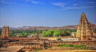
Hampi or Hampe, also referred to as the Group of Monuments at Hampi, is a UNESCO World Heritage Site located in Hampi (City), Ballari district now Vijayanagara district, east-central Karnataka, India. Hampi predates the Vijayanagara Empire; it is mentioned in the Ramayana and the Puranas of Hinduism as Pampa Devi Tirtha Kshetra. Hampi continues as a religious centre, with the Virupaksha Temple, an active Adi Shankara-linked monastery and various monuments belonging to the old city.

<span class="mw-page-title-main">Vijayanagara</span> City in Karnataka, India

Vijayanagara was a city at the modern location of Hampi, in the Indian state of Karnataka. Vijayanagara was the capital city of the historic Vijayanagara Empire. Located on the banks of the Tungabhadra River, it spread over a large area and included sites in the Vijayanagara district, the Ballari district, and others around these districts. A part of Vijayanagara ruins known as the Group of Monuments at Hampi has been designated as a UNESCO World Heritage Site.

<span class="mw-page-title-main">Vijayanagara Empire</span> Empire in Southern India (14th–17th centuries)

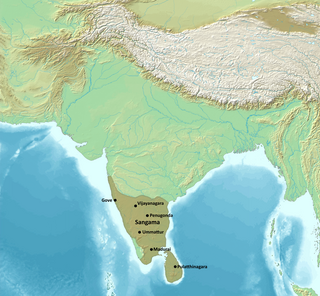
The Vijayanagara Empire was a medieval Indian empire that covered much of the region of Southern India, ruling the lands of the modern states of Karnataka, Andhra Pradesh, Tamil Nadu, Kerala, Goa, and some parts of Telangana and Maharashtra. It was established in 1336 by the brothers Harihara I and Bukka Raya I of the Sangama dynasty, members of a pastoralist cowherd community that claimed Yadava lineage. The empire rose to prominence as a culmination of attempts by the southern powers to ward off Turco-Persian Muslim invasions by the end of the 13th century. At its peak, it conquered almost all of Southern India's ruling dynasties and pushed the Turco-Persian sultans of the Deccan beyond the Tungabhadra-Krishna River doab region, in addition to annexing Gajapati Empire (Odisha) up to the Krishna River, thus becoming a notable power.

<span class="mw-page-title-main">Tungabhadra River</span> River in southern India

The Tungabhadra River is a river in India that starts and flows through the state of Karnataka during most of its course, Andhra Pradesh and ultimately joining the Krishna River near Murvakonda in Andhra Pradesh

<span class="mw-page-title-main">Achyuta Deva Raya</span> Emperor of Vijayanagara from 1529 to 1542

Achyuta Deva Raya was an Emperor of Vijayanagara who succeeded his older brother, the Emperor Krishna Deva Raya after the latter's death in 1529 CE.

<span class="mw-page-title-main">Hospet</span> City in Karnataka, India

Hospet or Hosapete is the largest and fastest-growing industrial city and district headquarters of the Vijayanagara district in the Indian state of Karnataka. Hosapete is known as "the steel city of Karnataka". It is located on the bank of the Tungabhadra River and is 13 km (8.1 mi) from Hampi (Vijayanagar). Hampi was once the capital of the Vijayanagara Empire. It has been designated a UNESCO World Heritage Site. Hospet is the connecting link between North and South Karnataka. It is 333 km (207 mi) from the state capital Bengaluru.

<span class="mw-page-title-main">Harihara II</span> Emperor of Vijayanagara

Harihara II was an Emperor of the Vijayanagara Empire from the Sangama Dynasty. He patronised the Kannada poet Madhura, a Jaina. An important work on the Vedas was completed during his time. He earned the titles Vaidikamarga Sthapanacharya and Vedamarga Pravartaka.

<span class="mw-page-title-main">Deva Raya I</span> Vijayanagara Emperor

Deva Raya I was a king of the Vijayanagara Empire. After Harihara II died, there was a dispute between his sons over succession, in which Deva Raya I eventually emerged victor. He was a very capable ruler noted for his military exploits and his support to irrigation works in his kingdom. He modernized the Vijayanagara army by improving the cavalry, employed skilled archers of the Turkic clans and raised the fighting capacity of his bowmen and imported horses from Arabia and Persia.

<span class="mw-page-title-main">Deva Raya II</span> Vijayanagara Emperor

Deva Raya II was an emperor of the Vijayanagara Empire. The greatest of the Sangama dynasty rulers, he was an able administrator, warrior, and scholar. He authored well-known works in the Kannada language and in the Sanskrit language. He was patron to some of the most noted Kannada poets of the medieval period, including Chamarasa and Kumara Vyasa, the Sanskrit poet Gunda Dimdima, and the noted Telugu language poet Srinatha, whom the king honored with the title Kavisarvabhauma. He supported development in secular literature as well as the noted South Indian mathematician Parameshvara, from the Kerala school of astronomy and mathematics lived in his empire.

<span class="mw-page-title-main">Virupaksha Raya II</span> Emperor

Virupaksha Raya II (1465–1485) was an Emperor of Vijayanagara from the Sangama dynasty.

Saluva Narasimha Deva Raya was an emperor of the Vijayanagara Empire from the Saluva Dynasty. A patron of the Madhwa saint Sripadaraya, he authored the Sanskrit work Rama Bhyudayam. He also patronised Kannada poet Kavi Linga.

The origin of the Vijayanagara Empire is a controversial topic in South Indian history, with regard to the linguistic affiliation of the founding dynasty, the Sangama family. The Vijayanagara Empire rose to power in southern India in the 14th century CE. Over the past decades historians have expressed differing opinions on whether the empire's founders, Harihara I and Bukka I, were of Kannada people or Telugu origin. There are various opinions about role of the Vidyaranya, the Hindu saint and guru of Harihara I and Bukka I in the founding of the Vijayanagara empire.

<span class="mw-page-title-main">Virupaksha Temple, Hampi</span> Temple in Karnataka, India

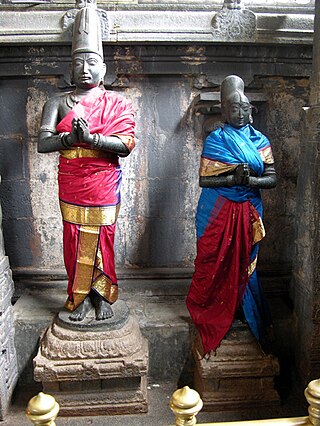
Virupaksha Temple is located in Hampi in the Vijayanagara district of Karnataka, India. It is part of the Group of Monuments at Hampi, designated as a UNESCO World Heritage Site. The temple is dedicated to Sri Virupaksha. The temple was built by Lakkan Dandesha, a nayaka (chieftain) under the ruler Deva Raya II, also known as Prauda Deva Raya of the Vijayanagara Empire.

<span class="mw-page-title-main">Vijayanagara architecture</span> Architecture of the Vijayanagara Empire, 1336–1565

Vijayanagara architecture of 1336–1565 CE was a notable building idiom that developed during the rule of the imperial Hindu Vijayanagara Empire. The empire ruled South India, from their regal capital at Vijayanagara, on the banks of the Tungabhadra River in modern Karnataka, India. The empire built temples, monuments, palaces and other structures across South India, with the largest concentration in its capital. The monuments in and around Hampi, in the Vijayanagara district, are listed as a UNESCO World Heritage Site.

<span class="mw-page-title-main">Society of Vijayanagara empire</span>

The period of the Vijayanagara Empire is considered an age of prosperity in South India in the 14th century CE. Many travelogues written by visitors, ambassadors and authors of that time provide ample proof of a vibrant era. Agriculture was the main sustenance and the Tungabhadra was the life blood of the capital city.

<span class="mw-page-title-main">Anegundi</span> Village in Karnataka, India

Anegundi, previously called Kishkindha, is a village in Gangavathi, Koppal district, in the Indian state of Karnataka. It is older than Hampi, situated on the northern bank of the Tungabhadra River. Nimvapuram, a nearby village, has a mount of ash believed to be the cremated remains of the monkey king Vaali.

<span class="mw-page-title-main">Hampi (town)</span> Town in Karnataka, India

Hampi or Vijayanagara is a town in the Vijayanagara district in the Indian state of Karnataka. Located along the Tungabhadra River in the east and center part of the state, Hampi is near the city of Hosapete. It is famous for hosting the Hampi Group of Monuments, a UNESCO World Heritage Site.

Veera Ballala IV, also Veera Virupaksha Ballala was the last Hoysala king. He was the eldest son and successor of the powerful Hoysala emperor Veera Ballala III. He resided over a declining Hoysala kingdom, and was in constant war with the Turko-Persian Madurai Sultanate and an upcoming Vijayanagara Empire.

<span class="mw-page-title-main">Matanga Hill</span> Hill in Karnataka, India

Matanga Hill is a rocky hill in the Matanga hill range, Hampi, Karnataka, southern India. The hill is supposedly a holy land from the Hindu Ramayana epic. The Matanga hill range served as a natural boundary of Hampi (Vijayanagara), which was the capital city of its namesake empire. Since the hills were a defense against attacks from outside lands, the Sangama brothers purposely put Vijayanagara there.

References