The Menina Pasture Plateau (Slovene : Menina planina) is a pre-Alpine karst plateau in Slovenia. [1]
The Menina Pasture Plateau (Slovene : Menina planina) is a pre-Alpine karst plateau in Slovenia. [1]
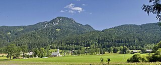
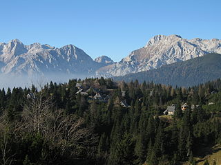
The plateau stands at an elevation between 1,200 and 1,450 meters (3,940 and 4,760 feet) in the Kamnik–Savinja Alps. [2] It is located between the Dreta Valley to the north, the Tuhinj Valley and Motnik Valley to the south, the Črnivec Pass to the west, and the Lipa Pass and Dobrovlje Plateau to the east. [2] The plateau is approximately 20 kilometers (12 mi) from east to west, and approximately 10 kilometers (6.2 mi) from north to south. The highest point on the plateau is Mount Vidovnik (1,508 meters or 4,948 feet), [1] [2] where there is also a lookout tower, about a 15-minute walk from the Menina Pasture Lodge (Slovene : Dom na Menini planini; 1,508 meters or 4,948 feet).
The plateau was attested in written sources in 1424 as Menino, and as Minitza in 1500. The name is believed to derive from a possessive form of the Slavic personal name *Měna. It is also possible, but less likely, that the name comes from *Mejnina planota 'border plateau', from the common noun meja 'border'. [3] Another theory derives the name from the noun menih 'monk', in connection with the former Benedictine abbey in Gornji Grad. [4] [5]

Jesenice is a Slovenian town and the seat of the Municipality of Jesenice on the southern side of the Karawanks, bordering Austria to the north. Jesenice is known as the Slovenian home of mining and iron making industries, its largest steel company Acroni, and its ice hockey club, HK Acroni Jesenice. Historically, Jesenice's ironworks and metallurgy industries were the driving force of the town's development.

Krma is an alpine valley in the Julian Alps in the Upper Carniola region of northwestern Slovenia. The entire valley lies in Triglav National Park.

Srednja Dobrava is a settlement in the Municipality of Radovljica in the Upper Carniola region of Slovenia.

Gozd is a small village in the Municipality of Kamnik in the Upper Carniola region of Slovenia. It includes the hamlets of Brška Vas, Gornja Vas, and Laze, as well as several isolated farms: Zabrezje or Brezovje, Brezovnik, Repovničar, Kajžar, Strahon, Hrastnik, Breg, and Zabrinje.

Kamniška Bistrica is a small dispersed settlement close to the source of the Kamnik Bistrica River in the Municipality of Kamnik in the Upper Carniola region of Slovenia.
Zgornje Jezersko is a settlement and administrative centre of the Municipality of Jezersko in northern Slovenia. It is part of the traditional Slovenian Carinthia region and the Upper Carniola Statistical Region.

Kopačnica is a dispersed settlement in a small valley northwest of Gorenja Vas in the Municipality of Gorenja Vas–Poljane in the Upper Carniola region of Slovenia.

Palčje is a village east of Pivka in the Inner Carniola region of Slovenia.
Podplanina is a small settlement in the Municipality of Loški Potok in southern Slovenia, next to the border with Croatia. The source of the Čabranka River lies just west of the village. The area is part of the traditional region of Lower Carniola and is now included in the Southeast Slovenia Statistical Region. It stands on terraces above the Čabranka River on steep slopes below Trava Peak. The settlement consists of a number of hamlets and individual houses. The core of the settlement is in the hamlet of Pri Kapelici.

Toško Čelo is a dispersed settlement on the slope of the hill known as Tošč Face, part of the Polhov Gradec Hills, west of the capital Ljubljana in central Slovenia. The area is part of the traditional region of Upper Carniola and is now included with the rest of the municipality in the Central Slovenia Statistical Region. It belongs to the City Municipality of Ljubljana.
The Big Pasture Plateau is a karstified mountain plateau in the Kamnik–Savinja Alps northeast of Kamnik, Slovenia. It measures 5.8 square kilometres and has an average elevation of 1,500 metres above sea level. Its highest point is Mount Gradišče, at 1,666 m (5,466 ft). There are numerous herders' dwellings that comprise several settlement areas: Velika Planina 'Big Pasture', Mala Planina 'Little Pasture', Gojška Planina 'Gozd Pasture', Tiha Dolina 'Quiet Valley', and others. The Big Pasture Plateau is a tourist destination both in winter as a ski resort and in summer as a place for relaxation.
Ćićarija, is a mountainous plateau in the northern and northeastern part of the Istria peninsula, 45 kilometers (28 mi) long and 10–15 kilometers (6.2–9.3 mi) wide. It mostly lies in Croatia, while its northern part lies in southwestern Slovenia. The highest peak is Veliki Planik at 1,272 meters (4,173 ft).
The Šalek Valley or the Velenje Basin is a basin in northern Slovenia in the northeastern pre-alpine foothills. It is named after Šalek Castle near the town of Velenje. The valley lies between the Kamnik–Savinja Alps to the west, the Pohorje Mountain Range to the east, and the Sava Hills to the south. It has a northwest-southeast orientation and is approximately 8 km long and 2 km wide. It contains a number of rivers and lakes. The Paka River runs through Velenje, with a number of tributaries from the northwest: Trebušnica Creek, Veriželj Creek and Slatina Creek. The Paka itself eventually flows into the Savinja River. The valley is separated from the Upper Savinja Valley and Lower Savinja Valley by the Golte Plateau, the Skorno Hills (Skornški hribi, peaks along the Paka including Mount Oljka, and the Ponikva Plateau.

Planina is a village in the Municipality of Semič in Slovenia. It lies on the southern slopes of Mount Mirna in the southern part of Kočevje Rog. It was inhabited by Gottschee Germans that were expelled in 1941 during the Second World War. The area is part of the historical region of Lower Carniola. The municipality is now included in the Southeast Slovenia Statistical Region.

Ratitovec is a mountain ridge in the Julian Alps in Slovenia. The highest peak on the ridge is Mount Altemaver. The Krek Lodge stands on the ridge.

The Trnovo Forest Plateau is a karst plateau that constitutes the extreme northwest end of the Dinaric Alps. The Trnovo Forest Plateau has a karst character, without surface watercourses and broken up by closed valleys, outcroppings, hills, caves, shafts, and smaller karst features: solution pans, rills, karrens, and other features. Significant karst features include ice caves. The vegetation inversion at Big Paradana Ice Cave in the eastern part of the plateau, measuring 385 meters (1,263 ft) by 1,550 meters (5,090 ft), is a locus classicus and in the past ice was harvested from it and exported via Gorizia and Trieste to Egypt.

The Lož Karst Field, also known as the Lož Valley, is a karst field in Inner Carniola in southwest Slovenia. It is the smallest karst field in Inner Carniola.

The Matk Cirque, in older sources also the Jezera Valley is an Alpine glacial valley in Slovenia.

The Bloke Plateau is an extensive bowl-like plateau in southwest Slovenia, part of the traditional region of Inner Carniola.

Zgornji Okrog is a former settlement in the Municipality of Kamnik in central Slovenia. It is now part of the village of Okrog pri Motniku. The area is part of the traditional region of Upper Carniola. The municipality is now included in the Central Slovenia Statistical Region.