
Maryneal is an unincorporated community in southern Nolan County, Texas, United States. It lies along FM 608 south of the city of Sweetwater, the county seat of Nolan County. Its elevation is 2,566 feet (782 m). Although Maryneal is unincorporated, it has a post office, with the ZIP code of 79535; the ZCTA for ZIP Code 79535 had a population of 181 at the 2000 census.
Nolan is an unincorporated community in southeastern Nolan County, Texas, United States. It lies along FM 126 southeast of the city of Sweetwater, the county seat of Nolan County. Its elevation is 2,493 feet (760 m). It so happens that this elevation of 2,493 feet is also the average elevation of the United States. Although Nolan is unincorporated, it has a post office, with the ZIP code of 79537; the ZCTA for ZIP Code 79537 had a population of 94 at the 2000 census.
Knickerbocker is an unincorporated community in southwestern Tom Green County, Texas, United States. It lies along Farm to Market Road 2335 southwest of the city of San Angelo, the county seat of Tom Green County. Its elevation is 2,051 feet (625 m). Although Knickerbocker is unincorporated, it has a post office, with the ZIP code of 76939.
Toyahvale is an unincorporated community in southern Reeves County, Texas, United States. It lies along State Highway 17 and FM 3078 south of the city of Pecos, the county seat of Reeves County. Despite its similar name, Toyahvale is distinct from the town of Toyah, which lies 25 miles (40 km) to the north. Its elevation is 3,323 feet (1,013 m). Although Toyahvale is unincorporated, it has a post office, with the ZIP code of 79786.

Cat Spring is an unincorporated community in southern Austin County, Texas, United States. It lies along FM 949 south of the city of Bellville, the county seat of Austin County. Its elevation is 308 feet (94 m). Although Cat Spring is unincorporated, it has a post office, with the ZIP code of 78933; the ZCTA for ZIP Code 78933 had a population of 76 at the 2000 census.
Tennyson is an unincorporated community in southeastern Coke County, Texas, United States. It lies along U.S. Route 277 southeast of the city of Robert Lee, the county seat of Coke County. Its elevation is 1,883 feet (574 m). Although Tennyson is unincorporated, it has a post office, with the ZIP code of 76953; the ZCTA for ZIP code 76953 had a population of 64 at the 2000 census.
Dawn is an unincorporated community in eastern Deaf Smith County, Texas, United States. It lies along FM 809 northeast of the city of Hereford, the county seat of Deaf Smith County. Its elevation is 3,802 feet (1,159 m). Although Dawn is unincorporated, it has a post office, with the ZIP code of 79025; the ZCTA for ZIP Code 79025 had a population of 138 at the 2000 census.
Aiken is an unincorporated community in western Floyd County, Texas, United States. It lies along U.S. Route 70 north of the city of Floydada, the county seat of Floyd County. Its elevation is 3,300 feet (1,006 m). Although Aiken is unincorporated, it has a post office, with the ZIP code of 79221.
Pottsville is an unincorporated community located in western Hamilton County in Central Texas. It lies along Fm-218 west of the city of Hamilton, the county seat of Hamilton County. Its elevation is 1,322 feet (403 m). Although Pottsville is unincorporated, it has a post office, with the ZIP code of 76565; the ZCTA for ZIP Code 76565 had a population of 142 at the 2000 census.
Midkiff is an unincorporated community in northeastern Upton County, Texas, United States. It lies along RM 2401 and FM 3095 north of the city of Rankin, the county seat of Upton County. Its elevation is 2,736 feet (834 m). Although Midkiff is unincorporated, it has a post office, with the ZIP code of 79755; the ZCTA for ZIP Code 79755 had a population of 245 at the 2000 census.
Vancourt is an unincorporated community in eastern Tom Green County, Texas, United States. It lies along U.S. Route 87 east of the city of San Angelo, the county seat of Tom Green County. Its elevation is 1,867 feet (569 m). Although Vancourt is unincorporated, it has a post office, with the ZIP code of 76955; the ZCTA for ZIP Code 76955 had a population of 108 at the 2000 census.
Carlsbad is a census-designated place and unincorporated community in northwest Tom Green County, Texas, United States. It lies along U.S. Route 87 northwest of the city of San Angelo, the county seat of Tom Green County. Its elevation is 2,024 feet (617 m). Although Carlsbad is unincorporated, it has a post office, with the ZIP code of 76934; the ZCTA for ZIP Code 76934 had a population of 1,332 at the 2000 census.
Dodge is an unincorporated community in eastern Walker County, Texas, United States, on the northern edge of the Sam Houston National Forest. It lies along FM 405 east of the city of Huntsville, the county seat of Walker County. Its elevation is 400 feet (122 m). Although Dodge is unincorporated, it has a post office, with the ZIP code of 77334; the ZCTA for ZIP Code 77334 had a population of 184 at the 2000 census.

Waring is an unincorporated community in northwestern Kendall County, Texas, United States. It lies along local roads and the Guadalupe River, northwest of the city of Boerne, the county seat of Kendall County. Its elevation is 1,345 feet (410 m). Although Waring is unincorporated, it has a post office, with the ZIP code of 78074; the ZCTA for ZIP Code 78074 had a population of 59 at the 2000 census. The community is part of the San Antonio Metropolitan Statistical Area.

Kendalia is an unincorporated community in northeastern Kendall County, Texas, United States.
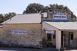
Bergheim is an unincorporated community in eastern Kendall County, Texas, United States. It lies along State Highway 46 east of the city of Boerne, the county seat of Kendall County. Its elevation is 1,437 feet (438 m). Although Bergheim is unincorporated, it has a post office, with the ZIP code of 78004; the ZCTA for ZIP Code 78004 had a population of 1,183 at the 2010 census. The community is part of the San Antonio Metropolitan Statistical Area.

Thomaston is an unincorporated community in southeastern DeWitt County, Texas, United States. It lies along U.S. Route 87 southeast of the city of Cuero, the county seat of DeWitt County. Its elevation is 161 feet (49 m). Although Thomaston is unincorporated, it has a post office, with the ZIP code of 77989.
Farnsworth is an unincorporated community in western Ochiltree County, Texas, United States. It lies at the intersection of State Highway 15 with FM376, southwest of the city of Perryton, the county seat of Ochiltree County. Its elevation is 2,995 feet (913 m). Although Farnsworth is unincorporated, it has a post office, with the ZIP code of 79033; the ZCTA for ZIP code 79033 had a population of 106 at the 2000 census.
Waka is an unincorporated community in western Ochiltree County, Texas, United States. It lies along State Highway 15 southwest of the city of Perryton, the county seat of Ochiltree County. Its elevation is 3,045 feet (928 m). Although Waka is unincorporated, it has a post office, with the ZIP code of 79093; the ZCTA for ZIP code 79093 had a population of 76 at the 2000 census.
Lelia Lake is an unincorporated community in central Donley County, Texas, United States. It lies along U.S. Route 287 southeast of the city of Clarendon, the county seat of Donley County. Its elevation is 2,592 feet (790 m). Although Lelia Lake is unincorporated, it has a post office, with the ZIP code of 79240; the ZCTA for ZIP code 79240 had a population of 101 at the 2000 census.


