Gold, commonly known as Gold Beach, was the code name for one of the five areas of the Allied invasion of German-occupied France in the Normandy landings on 6 June 1944, during the Second World War. Gold, the central of the five areas, was located between Port-en-Bessin on the west and the Lieu-dit La Rivière in Ver-sur-Mer on the east. High cliffs at the western end of the zone meant that the landings took place on the flat section between Le Hamel and La Rivière, in the sectors code-named Jig and King. Taking Gold was to be the responsibility of the British Army, with sea transport, mine sweeping, and a naval bombardment force provided by the Royal Navy as well as elements from the Dutch, Polish and other Allied navies.
The 90th Infantry Division was a unit of the United States Army that served in World War I and World War II. Its lineage is carried on by the 90th Sustainment Brigade.

The 90th Light Infantry Division was a light infantry division of the German Army during World War II that served in North Africa as well as Sardinia and Italy. The division played a major role in most of the actions against the British Eighth Army in the Western Desert Campaign and eventually surrendered to the Allies in the final stages of the Tunisia Campaign in May 1943. It was re-constituted later in 1943 and deployed to Sardinia and when the expected Allied invasion of Sardinia failed to materialise, the division was moved to Italy. It was engaged in actions against the Allies in Italy from 1943 to April 1945 when the division was listed as "destroyed" in the Po River valley.
Much of the focus of the discussion about Nazi gold concerns how much of it Nazi Germany transferred to overseas banks during World War II. The Nazis looted the assets of their victims to accumulate wealth. In 1998, a Swiss commission estimated that the Swiss National Bank held $440 million of Nazi gold, over half of which is believed to have been looted.
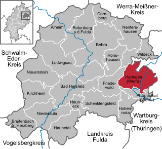
Heringen (Werra) is a small town in Hersfeld-Rotenburg district in eastern Hesse, Germany lying right at the boundary with Thuringia.
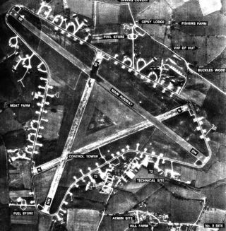
Royal Air Force Leiston or more simply RAF Leiston is a former Royal Air Force station located 1.5 km (0.93 mi) northwest of Leiston and 1 km (0.62 mi) south of Theberton, Suffolk, England.

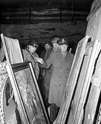
The Monuments, Fine Arts, and Archives Section Unit (MFAA) was a program established by the Allies in 1943 to help protect cultural property in war areas during and after World War II. The group of about 400 service members and civilians worked with military forces to protect historic and cultural monuments from war damage, and as the conflict came to a close, to find and return works of art and other items of cultural importance that had been stolen by the Nazis or hidden for safekeeping. Spurred by the Roberts Commission, MFAA branches were established within the Civil Affairs and Military Government Sections of Allied armies.

The 191st Infantry Brigade was constituted on 24 June 1921 in the Organized Reserves as Headquarters and Headquarters Company, 191st Infantry Brigade, and assigned to the 96th Division. It was organized in December 1921 at Portland, Oregon, and redesignated on 23 March 1925 as Headquarters and Headquarters Company, 191st Brigade, then redesignated on 24 August 1936 as Headquarters and Headquarters Company, 191st Infantry Brigade. It was converted and redesignated on 6 April 1942 as the 96th Reconnaissance Troop, 96th Division. The Troop was ordered into active military service on 15 August 1942 and reorganized at Camp Adair, Oregon, as the 96th Cavalry Reconnaissance Troop, an element of the 96th Infantry Division. It was reorganized and redesignated on 16 August 1943 as the 96th Reconnaissance Troop, Mechanized, and then again reorganized and redesignated on 20 November 1945 as the 96th Mechanized Cavalry Reconnaissance Troop. Following World War II service with the 96th Infantry Division in the Pacific, it was inactivated on 3 February 1946 at Camp Anza, California.
The 607th Tank Destroyer Battalion was a tank destroyer battalion of the United States Army active during the Second World War. They arrived in England during April, 1944, and entered combat in mid June, landing at Utah Beach. The unit fought across France and into Germany during the summer and early winter of 1944. In late winter, they were then pulled out and sent to Belgium near the end of the Ardennes Campaign and again fought their way into and across Germany, ending the war near the Czechoslovakian border. The 607th received credit for the Normandy, Northern France, Rhineland, Ardennes-Alsace and Central Europe campaigns.
The military uniforms of the Union Army in the American Civil War were widely varied and, due to limitations on supply of wool and other materials, based on availability and cost of materials. The ideal uniform was prescribed as a dark blue coat with lighter pants, with a black hat. Officer's ranks were denoted with increasing levels of golden decoration. Specific jobs, companies, and units had markedly different styles at times, often following European customs such as that of the Zouaves. Officers uniforms tended to be highly customized and would stray from Army standard. Ironically, several main pieces of gear had been created by order of the U.S. War Secretary Jefferson Davis before the war; he later became Confederate President.

John Armand Busterud was a Republican Assemblyman in the California legislature for the 22nd District. He was also Chair of the Council on Environmental Quality, was married to Anne Witwer and had three children: John, James and Mary.
The 99th Infantry Battalion (separate) was a battalion of Norwegian-speaking soldiers in the US Army. Created in July 1942 at Camp Ripley, Minnesota, the battalion originally consisted of 1,001 soldiers. The battalion was attached to the First Army; however, it was labeled "Separate" because it was not attached to a specific regiment.
Joel Hilton Fisher was a Lieutenant Commander of the US Coast Guard and member of the G-5 Intelligence Division of the US Army in World War II.

Merkers Adventure Mines are a visitor attraction in Krayenberggemeinde in the Wartburgkreis district of Thuringia, Germany, owned and operated by K+S AG of Kassel. They lie near the village of Merkers.
The German Nazi Party looted and stole art, gold and other objects that had been either plundered or moved for safekeeping at various storage sites during World War II. These sites included salt mines at Altaussee and Merkers and a copper mine at Siegen.
The 2nd Training Motorized Rifle Division named after Alp Arslan is a division of the Turkmen Ground Forces. Its headquarters is at Tejen in the Ahal Region. It traces its history to the 357th Rifle Division formed in August 1941 in Sarapul in the then Udmurt Autonomous Soviet Socialist Republic as a standard Red Army rifle division. It notably served on the front lines of the 1st Baltic Front during the Second World War. Particularly, it helped lead the 3rd Shock Army in the battle and siege of Velikiye Luki. By late October 1945, the division had been transferred to the Turkmen SSR, where it was re-designated four times as Soviet Army unit. It remained in Turkmenistan even after the events of 1991 and serves as one of four units in its armed forces.
The 358th Rifle Division formed in August 1941, as a standard Red Army rifle division, at Buguruslan. It first saw action in January 1942, taking part in the offensive northwest of Moscow which carved out the salient around Toropets deep in the rear of Army Group Center. The division remained on this general sector of the front, nearly the whole time in 4th Shock Army, until March 1944, when it was withdrawn for rebuilding. It was then assigned to 21st Army north of Leningrad where it participated in the offensive that drove Finland out of the war from June into August, and remained on this front until December. It was then reassigned to the 39th Army, under which it fought in East Prussia until April 1945. During that month the entire 39th Army began moving to the Far East, where it took part in the Soviet invasion of Manchuria in August, where the 358th won its second battle honor, capping a distinguished record of service.

The Rhön Cycleway is a cycle path in Germany that runs for 180 kilometres from Bad Salzungen to Hammelburg. Its route takes it through 3 states: from Thuringia via Hesse to Bavaria.
The 381st Rifle Division was raised in 1941 as an infantry division of the Red Army, and served for the duration of the Great Patriotic War in that role. It began forming in August, 1941 in the Urals Military District. It first served in the bitter fighting around the Rzhev salient, deep in the German rear in the 39th Army and came close to being completely destroyed in July, 1942. The division's survivors were moved north well away from the front for a major rebuilding. It returned to the front in October, joining the 3rd Shock Army for the battle and siege of Velikiye Luki. The division remained in this general area in western Russia until March, 1944, when it was moved to the Reserve of the Supreme High Command and then to 21st Army north of Leningrad in April. It served in the offensive that drove Finland out of the war from June to September, winning a battle honor and the Order of the Red Banner in the process, before being transferred back to the Soviet-German front in October. As part of the 2nd Shock Army of 2nd Belorussian Front the 381st advanced across Poland and Pomerania during the winter of 1945, then joined its Front's advance across the Oder River into north-central Germany in late April, ending the war on the Baltic coast. In the summer of that year the division was disbanded.

The 358th Infantry Regiment is a unit of the United States Army. Organized in 1917, it took part in both World War I and World War II as a subordinate unit of the 90th Infantry Division.