Mesa Prieta | |
---|---|
![]() | |
Coordinates: 35°28′26″N107°03′12″W / 35.473951°N 107.053356°W | |
Location | 25 km west of San Ysidro, NM |
Formed by | basaltic lava flow during the Pliocene |
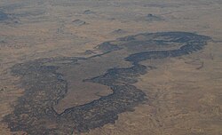
Mesa Prieta is a mesa in Sandoval County New Mexico. The mesa was formed by a basaltic lava flow during the Pliocene. The sedimentary rocks include the Cretaceous Dakota Sandstone, Mancos Shale, and Gallup Sandstone. [1]
The Rio Puerco flows south on the west side of the mesa. The Ojito Wilderness is to the east of the mesa, and Cabezon Peak is to the north.
The Entrada Sandstone is a formation in the San Rafael Group found in the U.S. states of Wyoming, Colorado, northwest New Mexico, northeast Arizona, and southeast Utah. Part of the Colorado Plateau, this formation was deposited during the Jurassic Period sometime between 180 and 140 million years ago in various environments, including tidal mudflats, beaches, and sand dunes. The Middle Jurassic San Rafael Group was dominantly deposited as ergs in a desert environment around the shallow Sundance Sea.
The Dolores River is a tributary of the Colorado River, approximately 241 miles (388 km) long, in the U.S. states of Colorado and Utah. The river drains a rugged and arid region of the Colorado Plateau west of the San Juan Mountains. Its name derives from the Spanish El Rio de Nuestra Señora de Dolores, River of Our Lady of Sorrows. The river was explored and possibly named by Juan Maria Antonio Rivera during a 1765 expedition from Santa Fe.
The Grand Mesa is a large mesa in western Colorado in the United States. It is the largest flat-topped mountain in the world. It has an area of about 500 square miles (1,300 km2) and stretches for about 40 miles (60 km) east of Grand Junction between the Colorado River and the Gunnison River, its tributary to the south. The north side of the mesa is drained largely by Plateau Creek, a smaller tributary of the Colorado. The west side is drained largely by Kannah Creek, which is received to the west by the lower Gunnison River. The mesa rises about 6,000 feet (1,800 m) above the surrounding river valleys, including the Grand Valley to the west, reaching an elevation of about 11,000 feet (3,400 m). Much of the mesa is within Grand Mesa National Forest. Over 300 lakes, including many reservoirs created and used for drinking and irrigation water, are scattered along the top of the formation. The Grand Mesa is flat in some areas, but quite rugged in others.
Ute Mountain, also known as Ute Peak or Sleeping Ute Mountain, is a peak within the Ute Mountains, a small mountain range in the southwestern corner of Colorado. It is on the northern edge of the Ute Mountain Ute Tribe Reservation. The Reservation forms the southwestern corner of the state and of Montezuma County.
The Cutler Formation or Cutler Group is a rock unit that is exposed across the U.S. states of Arizona, northwest New Mexico, southeast Utah and southwest Colorado. It was laid down in the Early Permian during the Wolfcampian epoch.
The Chinle Formation is an Upper Triassic continental geological formation of fluvial, lacustrine, and palustrine to eolian deposits spread across the U.S. states of Nevada, Utah, northern Arizona, western New Mexico, and western Colorado. In New Mexico, it is often raised to the status of a geological group, the Chinle Group. Some authors have controversially considered the Chinle to be synonymous to the Dockum Group of eastern Colorado and New Mexico, western Texas, the Oklahoma panhandle, and southwestern Kansas. The Chinle Formation is part of the Colorado Plateau, Basin and Range, and the southern section of the Interior Plains. A probable separate depositional basin within the Chinle is found in northwestern Colorado and northeastern Utah. The southern portion of the Chinle reaches a maximum thickness of a little over 520 meters (1,710 ft). Typically, the Chinle rests unconformably on the Moenkopi Formation.
The Point Lookout Sandstone is a Cretaceous bedrock formation occurring in New Mexico and Colorado.
The Pajarito Formation is a geologic formation in eastern New Mexico and west Texas. It preserves fossils dating back to the Albian Age of the Cretaceous Period.
The Mancos Shale or Mancos Group is a Late Cretaceous geologic formation of the Western United States.
The Defiance Plateau, part of the geologic Defiance Uplift, is an approximately 75-mile (121 km) long, mostly north-trending plateau of Apache County, Arizona, with its east and southeast perimeter, as parts of San Juan and McKinley Counties, New Mexico.
The Shinarump Conglomerate is a geologic formation found in the Four Corners region of the United States. It was deposited in the early part of the Late Triassic period.
The Cliff House Sandstone is a late Campanian stratigraphic unit comprising sandstones in the western United States.
The Mesa Rica Sandstone is a geologic formation in Oklahoma and New Mexico. It preserves fossils dating back to the Cretaceous period.
The Gray Mesa Formation is a geologic formation in New Mexico. Its fossil assemblage dates the formation to the Moscovian age of the Pennsylvanian.
The Gila Group is a group of geologic formations found along the upper tributaries of the Gila River in Arizona and New Mexico. Radiometric dating of lava flows within the group yields an age of Miocene to Quaternary.
The Baca Formation is a geologic formation in southern New Mexico and Arizona. It preserves fossils dating back to the Eocene period.
The Yeso Group is a group of geologic formations in New Mexico. It contains fossils characteristic of the Kungurian Age of the early Permian Period.
The Atrasado Formation is a geologic formation in New Mexico. Its fossil assemblage dates the formation to the Kasimovian age of the Pennsylvanian. It was formerly known locally as the Wild Cow Formation or the Guadelupe Box Formation.
The Ceja Formation is a Pliocene to Pleistocene geologic formation exposed near Albuquerque, New Mexico, United States.
The Zuni Sandstone is a geologic formation in west-central New Mexico. It marks the southernmost limit of Jurassic fluvial and lacustrine sedimentary formations, which pinch out to leave a single sandstone body.