
New Mexico is a state in the Southwestern United States. It is one of the Mountain States of the southern Rocky Mountains, sharing the Four Corners region of the western U.S. with Utah, Colorado, and Arizona, and bordering Texas to the east and southeast, Oklahoma to the northeast, and the Mexican states of Chihuahua and Sonora to the south. New Mexico's largest city is Albuquerque, and its state capital is Santa Fe, the oldest state capital in the U.S., founded in 1610 as the government seat of Nuevo México in New Spain.

Albuquerque, abbreviated ABQ, is the most populous city in the U.S. state of New Mexico. Its nicknames, The Duke City and Burque, both reference its founding in 1706 as La Villa de Alburquerque by Nuevo México governor Francisco Cuervo y Valdés. Named in honor of the Viceroy of New Spain, the 10th Duke of Alburquerque, the city was an outpost on El Camino Real linking Mexico City to the northernmost territories of New Spain. In 2006 the city celebrated its 300th anniversary.

Socorro is a city in Socorro County in the U.S. state of New Mexico. It is in the Rio Grande Valley at an elevation of 4,579 feet (1,396 m). In 2010 the population was 9,051. It is the county seat of Socorro County. Socorro is located 74 miles (119 km) south of Albuquerque and 146 miles (235 km) north of Las Cruces.

The Southwestern United States, also known as the American Southwest or simply the Southwest, is a geographic and cultural region of the United States that includes Arizona and New Mexico, along with adjacent portions of California, Colorado, Nevada, Oklahoma, Texas, and Utah. The largest cities by metropolitan area are Phoenix, Las Vegas, El Paso, Albuquerque, and Tucson. Before 1848, in the historical region of Santa Fe de Nuevo México as well as parts of Alta California and Coahuila y Tejas, settlement was almost non-existent outside of Nuevo México's Pueblos and Spanish or Mexican municipalities. Much of the area had been a part of New Spain and Mexico until the United States acquired the area through the Treaty of Guadalupe Hidalgo in 1848 and the smaller Gadsden Purchase in 1854.

Albuquerque International Sunport is the primary international airport serving the U.S. state of New Mexico, particularly the Albuquerque metropolitan area and the larger Albuquerque–Santa Fe–Las Vegas combined statistical area. It handles around 5.4 million passengers annually and over 400 flights daily. ABQ is located in Bernalillo County, New Mexico, between the Rio Grande river and the Sandia Mountains, east of Old Town Albuquerque and Barelas, 3 miles (5 km) southeast of Downtown Albuquerque, south of the University of New Mexico and directly to the west of Sandia National Laboratories and Kirtland Air Force Base.

Rio Grande Credit Union Field at Isotopes Park, previously known only as Isotopes Park, is a minor league baseball stadium located in Albuquerque, New Mexico, and is the home field of the Albuquerque Isotopes of the Pacific Coast League, the Triple-A affiliate of the Colorado Rockies. The facility was also previously used by the baseball program of the University of New Mexico.

University Stadium is an outdoor football stadium in the western United States, located on the south campus of the University of New Mexico in Albuquerque, New Mexico. It is the home field of New Mexico Lobos football, which competes as a member of the Mountain West Conference.

KASA-TV, branded on-air as Telemundo Nuevo México, is a television station licensed to Santa Fe, New Mexico, United States, serving the Albuquerque area and most of the state as an owned-and-operated station of the Spanish-language Telemundo network. KASA-TV's studios are located on Monroe Street NE in Albuquerque; its transmitter is located on Sandia Crest, with translators in much of the state and southwestern Colorado extending its signal.

Albuquerque High School is a public high school near Downtown Albuquerque, New Mexico, United States. It is a part of the Albuquerque Public Schools district. Enrollment at AHS stands at 1,741.
Rio Rancho is the most populous and largest city in Sandoval County, part of the expansive Albuquerque metropolitan area, in the U.S. state of New Mexico. A small portion of the city extends into northern Bernalillo County.

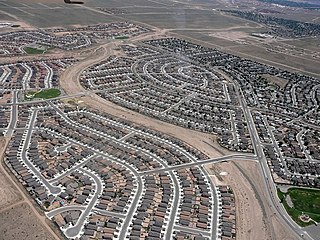
The Albuquerque Metropolitan Statistical Area, sometimes referred to as Tiguex, is a metropolitan area in central New Mexico centered on the city of Albuquerque. The metro comprises four counties: Bernalillo, Sandoval, Torrance, and Valencia. As of the 2010 United States Census, the MSA had a population of 887,077. The population is estimated to be 923,630 as of July 1, 2020, making Greater Albuquerque the 61st-largest MSA in the nation. The Albuquerque MSA forms a part of the larger Albuquerque–Santa Fe–Las Vegas combined statistical area with a 2020 estimated population of 1,165,181, ranked 49th-largest in the country.

The New Mexico Air National Guard is the aerial militia of the State of New Mexico, United States of America. It is, along with the New Mexico Army National Guard, an element of the New Mexico National Guard.

Valley High School is a public high school in the city of Albuquerque, New Mexico, United States. It is part of the Albuquerque Public Schools district. The school opened in 1954 and enrolls around 1,800 students.

Michelle Lynn Lujan Grisham is an American lawyer and politician serving as the 32nd governor of New Mexico since 2019. A member of the Democratic Party, Lujan Grisham previously served as the U.S. representative for New Mexico's 1st congressional district from 2013 to 2019.

The 2014 United States Senate election in New Mexico was held on November 4, 2014 to elect a member of the United States Senate. Incumbent Democratic Senator Tom Udall won reelection to a second term.
James Beliven Lewis is an American politician from the state of New Mexico. A member of the Democratic Party, he served as the state treasurer of New Mexico from 1985–1990 and from 2006–2014. To date, he is the only African American to serve in the role.
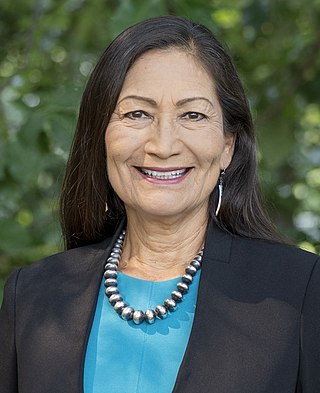
Debra Anne Haaland is an American politician serving as the 54th United States Secretary of the Interior. A member of the Democratic Party, she served as chair of the New Mexico Democratic Party from 2015 to 2017 and as the U.S. representative for New Mexico's 1st congressional district from 2019 to March of 2021. Haaland is a Native American and enrolled citizen of the Laguna Pueblo tribe.
New Mexico United is an American professional soccer team based in Albuquerque, New Mexico. Founded June 6, 2018, the team currently plays in the USL Championship, the second division of American soccer. The team is owned by Peter Trevisani, with head coach Eric Quill, and play their home games at Isotopes Park which has a capacity of around 13,500 people.
Shiprock Associated Schools, Inc. (SASI) is an organization that operates two schools associated with the Bureau of Indian Education (BIE) in Shiprock, New Mexico:

